 | Mala voda - Koreno
Koreno (also known as Korena) is a 729 m high hill located north of Horjul. From the summit, which features a large cross, the church of St. Moho...
1 h 15 min |
 | Podgorje - Kojnik (via hunting cottage)
Kojnik is a partly forested peak located in the southern part of Podgorski Kras near the Slovenian-Croatian border. From the summit, which has a ...
1 h 30 min |
 | Dobrič (Vedet) - Gora Oljka (by road)
Gora Oljka is a hill located east of Šmartno ob Paki. On the summit stands the Church of the Holy Cross, built in the mid-18th century. Just a fe...
50 min |
 | Tržič (Slap) - Kamnek (via Dobrivc)
Kamnek (Kamnik on maps, also sometimes Kamnjek) is a panoramic peak above Tržič....
1 h |
 | End of road below Jelovec - Castle Stari grad (Čušperk Castle)
Stari Grad, or Čušperk Castle, is located south of Grosuplje, more precisely west of the village of Čušperk. Of the castle, built in the 12th cen...
1 h 30 min |
 | Lučine - Sivka
Sivka is a grassy peak at the far western end of Polhograjsko hribovje. On clear days, it offers breathtaking views from Snežnik across Javorniki...
50 min |
 | Prelesje - Sivka
Sivka is a grassy peak at the far western end of Polhograjsko hribovje. On clear days, it offers breathtaking views from Snežnik across Javorniki...
1 h |
 | Olševek - Štefanja gora (via Apnišče)
Štefanja gora, where the Church of St. Stephen stands, is located above Cerklje na Gorenjskem. Just a few tens of meters below the summit lies th...
1 h 15 min |
 | Preddvor - Štefanja gora (on footpath)
Štefanja gora, where the Church of St. Stephen stands, is located above Cerklje na Gorenjskem. Just a few tens of meters below the summit lies th...
1 h 20 min |
 | Poljana (Završnica) - Sveti Lovrenc above Zabreznica (via Mali vrh)
Sveti Lovrenc is a viewpoint with an eponymous chapel on the southern slope of the Brezniške peči ridge, 180 elevation meters above the village o...
1 h |
 | Rovte - Medvedje Brdo (via Trtovška grapa)
Medvedje Brdo is a small settlement located north of Hotedršica. The highest point of the village is a pleasant viewpoint on Šinkovcov grič (814 ...
1 h 10 min |
 | Rodik - Sveti Socerb (Artviže)
The Church of St. Socerb is located on a panoramic hill above the village of Artviže, which at 817 meters is the highest peak of the Brkini. From...
1 h 20 min |
 | Gorenji Novaki (Mrovlje) - Škofje
Škofje is a 973-meter-high peak located above the villages of Čeplez, Planina pri Cerknem, and Podpleče. The summit itself, marked by a small con...
1 h |
 | Trojane - Lipovec
Lipovec is an 848-meter-high peak located above the pastures of Lipovec. On clear days, the summit offers views of the Posavsko hribovje, Kum, Me...
1 h 30 min |
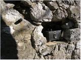
 | Parje - Šilentabor
Šilentabor is a 751-meter-high peak just above the village of the same name. From the summit, near which there is a bench and a logbook box, ther...
1 h 15 min |
 | Šembije - Gradišče (Čepan)
Gradišče (also Čepan) is a 791-meter-high peak in the ridge between Šembije and Pivka. At 791 meters, it marks the highest point of the Brkini ed...
1 h 20 min |
 | Podljubelj - Veliki vrh above Završnik
Veliki vrh above Završnik is a 968 m high mountain located in the Pirmance ridge, north to northeast of Tržič. From the grassy summit, which feat...
1 h 20 min |
 | Činžat - Lobnikov vrh
Lobnikov vrh is a forested peak above the Dravska dolina valley, located between the settlements of Fala and Ruta. From the east, due to its remo...
1 h |
 | Čepovan (Želinc) - Vrh Skopice
Vrh Skopice, also known as Skopica, is a panoramic peak located between the Čepovan Valley, the Idrijca River valley, and the Trebuščica River va...
50 min |
 | Brezje nad Kamnikom - Vovar (western way)
A viewless hill in front of the Kamnik mountains. In recent times, due to storms, it is crisscrossed with cart tracks for log extraction.Below th...
1 h |
| Brezje nad Kamnikom - Vovar (northern way)
A viewless hill in front of the Kamnik mountains. In recent times, due to storms, it is crisscrossed with cart tracks for log extraction.Below th...
1 h |
 | Babni Vrt - Gradišče (Pustinjak) (through forest and past Sveti Lovrenc)
Gradišče or Pustinjak (also Gradišče nad Bašljem) is an 871-meter-high peak located above the Belica stream, which lies below the 2,132-meter-hig...
1 h 15 min |
| Povlje - Gradišče (Pustinjak)
Gradišče or Pustinjak (also Gradišče nad Bašljem) is an 871-meter-high peak located above the Belica stream, which lies below the 2,132-meter-hig...
1 h 5 min |
 | Col - Križna gora above Col
Križna gora is a 957-meter-high peak located north of Col. From the summit, which is forested on the northern side, beautiful views open up to th...
55 min |
 | Logatec (Gorenja vas) - Šenčurjev vrh (via Žibrše)
Šenčurjev vrh is a 725-meter-high hill located above the settlement of Žibrše, which lies between Logatec, Hotedršica, and Rovte. At the summit, ...
1 h 30 min |
 | Olševek - Apnišče (west path)
Apnišče is a 740 m high mountain between Možjanca and Štefanja gora. It is the highest point of the Šenčur municipality. The forested summit offe...
55 min |
 | Olševek - Apnišče (via Šterna)
Apnišče is a 740 m high mountain between Možjanca and Štefanja gora. It is the highest point of the Šenčur municipality. The forested summit offe...
55 min |
| Adergas - Apnišče (via Šterna)
Apnišče is a 740 m high mountain between Možjanca and Štefanja gora. It is the highest point of the Šenčur municipality. The forested summit offe...
1 h |
 | Preddvor - Apnišče (on footpath)
Apnišče is a 740 m high mountain between Možjanca and Štefanja gora. It is the highest point of the Šenčur municipality. The forested summit offe...
1 h 15 min |
 | Kočna - Vrše (čez senožeti)
The 850-meter-high hill Vrše, over which the Triglav National Park border runs, rises southwest above the village of Blejska Dobrava, or east of ...
50 min |
 | Poljane (Spodnje Gorje) - Boršt (by road)
Boršt is a 931-meter-high vegetated peak located 4 km northwest of Bled, or east of the Mežakla Plateau. Between it and the neighboring peak Hom ...
1 h |
 | Kočna - Boršt (via Vrše)
Boršt is a 931-meter-high vegetated peak located 4 km northwest of Bled, or east of the Mežakla Plateau. Between it and the neighboring peak Hom ...
1 h 20 min |
 | Trate (Blejska Dobrava) - Boršt
Boršt is a 931-meter-high vegetated peak located 4 km northwest of Bled, or east of the Mežakla Plateau. Between it and the neighboring peak Hom ...
1 h |
 | Možjanca - Skutman
Skutman is a lesser-known peak above the left bank of the Kokra River and north of Štefanja Gora. The summit is marked by a metal plaque reading ...
1 h 25 min |
 | Možjanca - Skutman (via Zapečnikova planina)
Skutman is a lesser-known peak above the left bank of the Kokra River and north of Štefanja Gora. The summit is marked by a metal plaque reading ...
1 h 25 min |
 | Podblica - Sleme (Površnica)
Sleme is a panoramic peak located between Rudno, Dražgoše, and Lajše. From the summit, where transmitters are located, there is a nice view of th...
1 h 10 min |
 | Podblica - Sveti Križ above Selca (via Sleme)
The Church of the Holy Cross above Selca is situated on a panoramic hill from which a beautiful view opens up over part of the Škofjeloško hribov...
1 h 30 min |
 | Prevalje - Brinjeva gora (above Prevalje) (via Stations of the Cross)
Brinjeva gora is a popular excursion spot for Prevalje locals, located between the Meža River and Zelenbreški Stream. On the summit stands a smal...
1 h |
| Prevalje - Brinjeva gora (above Prevalje) (south path)
Brinjeva gora is a popular excursion spot for Prevalje locals, located between the Meža River and Zelenbreški Stream. On the summit stands a smal...
1 h |
 | Šentviška Gora - Črvov vrh
Črvov Vrh, also known as Črvov Grič, is the highest peak of the Šentviška Planota at 974 metres. The plateau rises above the right bank of the Id...
1 h 10 min |
 | Bukovo - Bukovski vrh
Bukovski Vrh (918 m) lies above the settlement of Bukovski Vrh, more precisely above the Pri Pircu homestead. From the grassy summit there is a f...
1 h 20 min |
| Šentviška Gora - Bukovski vrh
Bukovski Vrh (918 m) lies above the settlement of Bukovski Vrh, more precisely above the Pri Pircu homestead. From the grassy summit there is a f...
1 h 30 min |
 | Ledinsko Razpotje - Krog (Ledinski grič)
Krog is a 940-metre-high peak on the western part of the Ledinski grič ridge, between the streams Jerešča and Ledinščicaboth left tributaries of ...
1 h 30 min |
 | Veliko Tinje - Repnikov vrh
Repnikov vrh is a 988-meter-high peak on Pohorje, located between Planina pod Šumikom and Urh. The summit is in the middle of the forest, along a...
1 h 25 min |
 | Lovrenc na Pohorju (cemetery) - Koglerjev vrh (via Hožičev vrh)
Koglerjev vrh is a 698-meter-high forested peak located southwest of the organic farm Šlaus-Kogler, which lies above the settlement of Lovrenc na...
1 h |
 | Škalnica - Pliševica (Way of the Cross)
Pliševica is a panoramic grassy summit above Škalnica, near the Slovenian border. From the top, marked by a concrete stone with a logbox, beautif...
50 min |