 | Ravne - Jerebikovec
The panoramic, slightly overgrown peak is located above Mojstrana and Radovna. From the summit, there is a beautiful view towards the Karawanks a...
2 h 45 min |
| Planina Spodnji Kozjek - Jerebikovec
The panoramic, slightly overgrown peak is located above Mojstrana and Radovna. From the summit, there is a beautiful view towards the Karawanks a...
2 h 30 min |
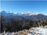
 | Preval Hlevišče - Koprivnik (via Brdo)
Koprivnik is a 1393-meter-high mountain located between Blegoš and Mladi vrh. From the summit, which has a registration box and a stamp, the view...
2 h |
 | Kozarnice - Srednji Golak (unmarked eastern way)
Srednji Golak is located between Mali and Veliki Golak on the plateau of Trnovski gozd above Predmeja. The peak is covered with dwarf pines, and ...
1 h 45 min |
 | Zatrnik - Galetovec
Galetovec is an indistinct peak on the southeastern part of the Pokljuka plateau. From the summit, which has a logbook, there is a nice view of t...
2 h |
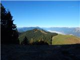
 | Laze - Črni vrh above Novaki
Črni vrh, the highest point of the popular Cerkno ski center, is located northeast of Novaki. Near the summit, where an artificial lake has been ...
2 h |
 | Preval Hlevišče - Mladi vrh
Mladi vrh is the higher neighbor of the better-known Stari vrh, separated from it by a saddle. Covered in sparse beech forest, the summit offers ...
1 h 45 min |
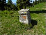
 | Makekova Kočna - Javornik above Jezersko
Javornik is a forested peak between the valleys of Ravenska Kočna and Makekove Kočna. There is no view from the summit due to the trees, but near...
1 h 45 min |
 | Solarji - Kuk (Kolovrat)
Kuk is the highest peak of the Kolovrat range at 1243 m. The range extends from Livek to Kambreško. From the summit, which has several transmitte...
2 h 10 min |
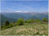
 | Podmeja - Javor
Javor is a 1,132-meter-high peak situated between Kisovec and Sveta Planina. The summit, covered with forest, offers no views, but a nice panoram...
2 h |
 | Javorje - Hunting cottage Na Glinu
The hunting cottage Na Glinu is situated on a panoramic hill between the mountain pastures Suha and Poljana. From the cottage there opens a nice ...
2 h |
| Pod Debelo glavo - Hunting cottage Na Glinu
The hunting cottage Na Glinu is situated on a panoramic hill between the mountain pastures Suha and Poljana. From the cottage there opens a nice ...
2 h 15 min |
| Pod Debelo glavo - Hunting cottage Na Glinu (via hunting cottage)
The hunting cottage Na Glinu is situated on a panoramic hill between the mountain pastures Suha and Poljana. From the cottage there opens a nice ...
2 h 30 min |
 | Planina Kuk - Grušnica
Grušnica is a 1,570-meter-high peak located between Čadrg, the Tolminka valley, and Tolminske Ravne. From the summit, which drops steeply toward ...
2 h 45 min |
 | Pod Debelo glavo - Gradovec (via hunting cottage)
Gradovec is a 1,692-meter-high peak located north of the ridge of Spodnje Bohinjske gore, specifically above the mountain pasture Poljana. From t...
1 h 50 min |
 | Polja - Petelinjek (above Korensko sedlo) (via Kališje)
Petelinjek is a smaller ridge located west to southwest of Korensko sedlo. The ridge is mostly on the Slovenian side, with only the highest peak ...
2 h |
 | Bela Peč - Ojstri vrh (above Prevala) (via Ovčje jame)
Ojstri vrh is a 1,197-meter-high mountain located between the Seduc peak and Prevala. From the summit, there is a beautiful view of the surroundi...
1 h 45 min |
 | Koprivna (Kumer) - Čofatijev vrh (via Šoparjev vrh)
Čofatijev vrh is a panoramic mountain between the Koprivna and Topla valleys. From the top, a beautiful view opens up on the mountains above both...
1 h 45 min |
| Pod Peco / Koprein-Petzen - Čofatijev vrh (via Šoparjev vrh)
Čofatijev vrh is a panoramic mountain between the Koprivna and Topla valleys. From the top, a beautiful view opens up on the mountains above both...
2 h 10 min |
| Topla (Končnik) - Čofatijev vrh (via Šoparjev vrh)
Čofatijev vrh is a panoramic mountain between the Koprivna and Topla valleys. From the top, a beautiful view opens up on the mountains above both...
1 h 50 min |
 | Šumahovo sedlo - Jesenik (Jesenikov vrh) (via Veliki and Pikov vrh)
Jesenik, also known as Jesenikov vrh, is a 1,199-meter-high forested peak situated between Mežica and Podpeca....
1 h 45 min |
 | Poden / Bodental - Veliki Rob / Großer Rain
Veliki Rob / Großer Rain is a 1,464-meter-high peak located on the Austrian side of the Karawanks, specifically in the ridge above the Poden / Bo...
1 h 50 min |
| Poden / Bodental - Veliki Rob / Großer Rain (via Veronjak / Hausberg)
Veliki Rob / Großer Rain is a 1,464-meter-high peak located on the Austrian side of the Karawanks, specifically in the ridge above the Poden / Bo...
2 h 10 min |
| Slovenji Plajberk / Windisch Bleiberg - Veliki Rob / Großer Rain
Veliki Rob / Großer Rain is a 1,464-meter-high peak located on the Austrian side of the Karawanks, specifically in the ridge above the Poden / Bo...
2 h 10 min |
 | Slovenji Plajberk / Windisch Bleiberg - Rabenberg
Rabenberg is a 1,465 m high peak located in the Žingarica / Singerberg ridge. From the summit, there is a partial view to the northwest, while fo...
1 h 45 min |
| Plajberški graben / Bleiberger Graben - Rabenberg
Rabenberg is a 1,465 m high peak located in the Žingarica / Singerberg ridge. From the summit, there is a partial view to the northwest, while fo...
1 h 45 min |
 | Straßegg - Plankogel
Plankogel is a 1531-meter-high mountain situated in the Almenland nature park. From the panoramic summit, where a cross stands, a beautiful view ...
2 h 30 min |
 | Teichalm (Parking Heulantsch) - Zechnerschlag (Rohregg)
Zechnerschlag, or Rohregg, is a 1434-meter-high mountain situated in the Almenland nature park. From the summit, where a cross stands, a beautifu...
3 h 15 min |