 | Preval - Polhograjska Grmada
Polhograjska Grmada is an 898 m high peak located in the heart of the Polhograjski Dolomiti. The summit, which has a registration box with a stam...
2 h 45 min |
 | Preska - Sveti Jakob (via Turnice)
The Church of St James is located on a hill north of the village of Topol near Medvode. From the top, where there is a registration box with a st...
3 h |
| Preska - Sveti Jakob (via Jeterbenk)
The Church of St James is located on a hill north of the village of Topol near Medvode. From the top, where there is a registration box with a st...
3 h 15 min |
 | Zgornja Besnica (Podrovnik) - Sveti Jošt above Kranj (via Gaber)
Sveti Jošt above Kranj, is a hill located to the west of the slightly lower Šmarjetna Gora. From the top, where the Church of St. Jošto and the J...
2 h 30 min |
 | Vače - Zasavska Sveta gora (on a slope)
Zasavska Sveta gora is a popular excursion point located between Litija and Izlaki. From the top, where the parish church of the Nativity of the ...
2 h 30 min |
| Vače - Zasavska Sveta gora (on the ridge)
Zasavska Sveta gora is a popular excursion point located between Litija and Izlaki. From the top, where the parish church of the Nativity of the ...
2 h 35 min |
 | Žiri - Vrh Svetih Treh Kraljev
The Church of the Holy Three Kings is situated on a lookout above the village of Vrh Svetih Treh kraljev. From the top, which has an observation ...
2 h 30 min |
 | Moravče - Slivna (Pivkelj)
Slivna or Pivkelj (also Pivkelj turn) as this peak is also called is located south of Limbarska Gora. Pivkelj is also the highest point of the Mo...
2 h 30 min |
 | Divje jezero - Hleviška planina (via Prižnica)
Hleviška planina (also Hleviška planina) is a slightly overgrown but still very scenic peak. From the top, which is the house mountain of Idrija,...
2 h 30 min |
 | Preska - Rog (via Turnice)
The Rog is a 798 m high peak located above the village of Topole, just 10 minutes from St Catherine's Church. From the top of the hill, where a l...
2 h 30 min |
| Preska - Rog (via Jeterbenk)
The Rog is a 798 m high peak located above the village of Topole, just 10 minutes from St Catherine's Church. From the top of the hill, where a l...
2 h 45 min |
 | Velike Lašče - Kamen vrh (via Gornje Retje and Grmada)
Kamen vrh is a scenic peak located on the northern outskirts of Mala Gora. From the top, surrounded by low bushes, there is a beautiful view of p...
2 h 35 min |
 | Ribnica (Lepovče) - Grmada on Mala gora (via Stene Svete Ane)
Grmada (also Grmada nad Ortnek) is an 887 m high peak located above the village of Vrh pri Poljanah in the Mala Gora mountain range. Just a few m...
3 h 50 min |
 | Zavrh pri Trojanah - Golčaj
Golčaj is a 690 m high hill rising south of Blagovica. On the top, which has a registration box and a stamp, stands the NOB monument, and a few 1...
2 h 30 min |
 | Zazid - Golič (via Lipnik)
Golič is a grassy ridge stretching from Kojnik to the Slovenian-Croatian border and continuing to Žbevnica on the Croatian side. Due to the relat...
2 h 30 min |
 | Zazid - Golič (via Kojnik)
Golič is a grassy ridge stretching from Kojnik to the Slovenian-Croatian border and continuing to Žbevnica on the Croatian side. Due to the relat...
2 h 30 min |
| Podgorje - Golič (via hunting cottage)
Golič is a grassy ridge stretching from Kojnik to the Slovenian-Croatian border and continuing to Žbevnica on the Croatian side. Due to the relat...
2 h 40 min |
 | Rakovica - Špičasti hrib
Špičasti hrib (Špičasti vrh on maps) is an 837 m high peak located to the west of Sveti Jošto above Kranj. There is no view from the top, which h...
2 h 20 min |
 | Zazid - Kavčič (via Lipnik)
Kavčič is a grassy peak located above the village of Rakitovec on the Slovenian Croatian border. From the top, where there are two crosses and a ...
2 h 30 min |
 | Kopačnica - Veliki vrh (Lajše)
Veliki vrh is an almost 900 m high peak rising south of Cerkno. From the top, where there are several television and radio transmitters covering ...
2 h 50 min |
 | Mlinše - Pleše (via Zasavska Sveta gora)
Pleše is an 866 m high peak located between the Marela Ski Resort and Zasavska Sveta Gora. From the top, where the NOB monument is located, you h...
2 h 30 min |
 | Letuš - Grmada (Dobrovlje)
Grmada is an 898 m high forested peak located in the south-eastern part of the Dobrovlje plateau. The summit, on which the stamp is located, is n...
2 h 25 min |
 | Planina pri Sevnici - Debeli vrh (Bohor)
Debeli vrh is a 921-metre-high peak on Bohor between Veliki Koprivnik and Oslice. It is overgrown with dense forest, so there are no views. There...
2 h 30 min |
 | Planina pri Sevnici - Brest (Bohor) (via Škofov travnik)
Brest is a peak on Bohor although it loks more like a saddle. It is an important intersection of the Bohor trails. It lies between Oslica, which ...
2 h 35 min |
| Planina pri Sevnici - Brest (Bohor) (northern path)
Brest is a peak on Bohor although it loks more like a saddle. It is an important intersection of the Bohor trails. It lies between Oslica, which ...
2 h 20 min |
 | Lovrenc na Pohorju - Hlebov vrh (Rdeči Breg) (via Povh and Brabar)
The Red Bank stretches between the Radoljna Gorge in the east, the Drava River in the north and the Velka Stream in the east. It is separated fro...
2 h 30 min |
| Puščava - Hlebov vrh (Rdeči Breg)
The Red Bank stretches between the Radoljna Gorge in the east, the Drava River in the north and the Velka Stream in the east. It is separated fro...
2 h 55 min |
| Lovrenc na Pohorju - Hlebov vrh (Rdeči Breg) (via Kapus)
The Red Bank stretches between the Radoljna Gorge in the east, the Drava River in the north and the Velka Stream in the east. It is separated fro...
2 h 40 min |
 | Bezgovica - Loška stena
Loška stena is located above the Upper Kolpa Valley, specifically above the villages of Grintovec pri Osilnici, Ložec and Ribjek. From the top of...
2 h 40 min |
 | Dravograd (Meža) - Anski vrh (above Pameče)
Anski vrh is a lookout point above Pameče, on which the Church of St Anne stands. From the church or the surrounding area, we have a beautiful vi...
3 h |
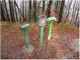
 | Graz Center West - Fürstenstand (Plabutsch) (via Buchkogel)
At 754 m, Fürstenstand is the highest peak of Plabutsch. It lies to the west of the city of Graz and rises about 400 m high.At the top stands the...
4 h |
 | Rechnitz (Badesee) - Irrotkő / Geschriebenstein
Irrotkő is the highest peak of the Kőszegi Hegység (Kőszegi Mountains) and also the highest peak in western Hungary and the Austrian state of Bur...
2 h 30 min |
 | Lockenhaus - Irrotkő / Geschriebenstein (via Weidriegel)
Irrotkő is the highest peak of the Kőszegi Hegység (Kőszegi Mountains) and also the highest peak in western Hungary and the Austrian state of Bur...
2 h 45 min |
| Lockenhaus - Irrotkő / Geschriebenstein (through Marchgraben)
Irrotkő is the highest peak of the Kőszegi Hegység (Kőszegi Mountains) and also the highest peak in western Hungary and the Austrian state of Bur...
2 h 40 min |
 | Lovrenc na Pohorju - Klančnik (Glančnik) (via Povh, Brabar and Hudej)
Klančnik, also known as Glančnik on some maps, is an 877-metre-high peak located above the right bank of the Drava River, just a few minutes away...
2 h 25 min |
 | Male Drage - Okrugljak (via Razdrto)
...
2 h 30 min |