Similar trips - Hrastnik - Ostri vrh
 | Briše - Polhograjska Gora (Sveti Lovrenc) (steep path)
Polhograjska Gora, also just Gora or Sveti Lovrenc, is an 824 m high hill located north-west of Polhov Gradec. From the top of the hill, where th...
1 h 30 min |
 | Rimske Toplice (Šmarjeta) - Kopitnik (via Lurd)
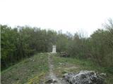
Kopitnik is a precipitous peak located north of Zidanega Most and south of Rimske Toplice. From the summit, which has a registration box, there i...
2 h 5 min |
| Rimske Toplice - Kopitnik (via Ogeški potok)
Kopitnik is a precipitous peak located north of Zidanega Most and south of Rimske Toplice. From the summit, which has a registration box, there i...
2 h 5 min |
 | Rimske Toplice - Kopitnik (via Borovo and Lukovški preval)
Kopitnik is a precipitous peak located north of Zidanega Most and south of Rimske Toplice. From the summit, which has a registration box, there i...
2 h 5 min |
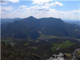
 | Marija Reka (Strgar Quarry) - Golava (Ovčja pot)
Golava is a peak located north of Mrzlica. From the summit, on which a small bivouac (Blaž's bivouac) stands, there is a beautiful view towards t...
1 h 45 min |
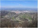 | Zagrad - Grmada above Celje (steep path)
What Šmarna Gora is to the inhabitants of Ljubljana, Grmada is to the inhabitants of Celjá. The hut mountain of Celje is located south of the tow...
1 h 15 min |
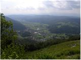
 | Zgornja Rečica (church of Blessed Anton Martin Slomšek) - Baba (above Rečica)
Baba (also known as Babe in some accounts) is a lookout point that rises steeply above Zgornja Rečica. From the top of the hill, where the regist...
1 h 15 min |
 | Novo Selo Okićko - Čerga (Plešivica)
Čerga (779 m) is the highest peak of Plešivica, a long ridge in the southern part of the Samobor Mountains, a kind of extension of Žumberacka Mou...
1 h 45 min |
 | Sveti Jurij - Donačka gora (eastern peak) (western path)
The East Peak Donačka gora is a precipitous peak 883 metres high, offering a beautiful view of the eastern part of Karawanks and part of the Halo...
1 h 55 min |
 | Borak - Kula (Omiška Dinara)
...
1 h 45 min |