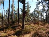
 | Trdkova - Bogin breg
Bogin breg is a 371-meter-high hill situated between Dolič and Trdkovo. From the summit, where a transmitter stands, there is no nice view due to...
25 min |
 | Gornji Četar / Felsőcsatár - Nagyvilágos mérőtorony (pot zeleni trikotnik)
Nagyvilágos mérőtorony is a former geodetic tower now converted into a lookout tower. It stands atop Četarski breg in western Vas County (Železna...
35 min |
 | Gorjuša - Sveta Kunigunda on Tabor above Ihan
The Church of St. Kunigunda on Tabor above Ihan was first mentioned in 1519. From the church or its nearby surroundings, there are limited views ...
35 min |
 | Trdkova - Tromejnik / Dreiländerecke / Harmashatar (Ježkova pot - through forest)
Tromejnik, known in German as Dreiländerecke or in Hungarian as Hármashatár, is a 390 m high hill located at the tripoint between Slovenia, Austr...
25 min |
 | Oberdrosen - Tromejnik / Dreiländerecke / Harmashatar
Tromejnik, known in German as Dreiländerecke or in Hungarian as Hármashatár, is a 390 m high hill located at the tripoint between Slovenia, Austr...
30 min |
 | Trdkova - Holzmannkogel (on marked path through the forest)
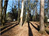
Holzmannkogel is a 393-meter-high hill located north of Tromejnik. The summit is forested and offers no significant views....
35 min |
| Oberdrosen - Holzmannkogel
Holzmannkogel is a 393-meter-high hill located north of Tromejnik. The summit is forested and offers no significant views....
30 min |
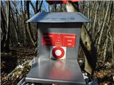
 | Jama Pekel (parkirišče) - Pogorišče (gentle path)
Pogorišče is a forested peak located on the Ponikovski Kras. At the top, or slightly below the highest point of the hill, there is a register box...
25 min |
 | Preserje - Žalostna gora at Preserje
Žalostna gora at Preserje is a 418-meter-high hill situated above the settlements of Prevalje pod Krimom and Kamnik pod Krimom. On the summit sta...
30 min |
 | Gorica pri Slivnici - Gaj
Gaj is a 419-meter-high hill located above Gorica pri Slivnici. From the logbook box, slightly below the highest point of the hill, there is a be...
30 min |
| Vezovje (bus station Vezovje most) - Gaj
Gaj is a 419-meter-high hill located above Gorica pri Slivnici. From the logbook box, slightly below the highest point of the hill, there is a be...
30 min |
 | Zgornja Kungota - Čajžič
Čajžič is a smaller hill located northwest of Zgornja Kungota. Its summit, a popular hiking spot for local residents, has a bench and a logbook b...
35 min |
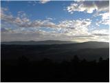
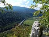 | Radenski kal - Mala Radenska stena
Mala Radenska stena rises above Radenci, offering fine views of Radenci, the Kolpa River, and parts of Croatia....
35 min |
 | Gorica pri Slivnici - Peseke
Peseke is a 428-meter-high hill located south of Slivniško Lake. From the viewpoint, where there is also a summit register box and a bench, a bea...
30 min |
 | Tivoli - Šišenski hrib (Rožnik) (by road)
Šišenski hrib, at 429 m, is the highest peak of Rožnik, the hill that rises above the centre of Ljubljana. From the summit, where several transmi...
30 min |
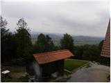
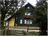 | Mengeš - Mengeška koča on Gobavica (on trim trail)
Gobavica is a hill rising above Mengeš. Mengeška koča mountain hut stands on it, along with a goat pen. It is one of the starting points for the ...
30 min |
 | Gorica pri Slivnici - Gradišče (above Slivniško jezero) (eastern path)
Gradišče above Slivniško Lake lies between the settlements of Gorica pri Slivnici and Tratna pri Grobelnem. From the logbook box on Gradišče, a f...
35 min |
 | Topole - Debeli vrh (above Topole)
Debeli vrh is a forest-covered peak located between the settlements of Koseze and Topole. On the summit there is a small wooden cross attached to...
25 min |
 | Koseze - Debeli vrh (above Topole)
Debeli vrh is a forest-covered peak located between the settlements of Koseze and Topole. On the summit there is a small wooden cross attached to...
25 min |
 | Gračišče - Lačna
Lačna is a 451-meter-high hill located between Gračišče, Kubed, and Hrastovlje. The summit, which features a metal observation tower offering nic...
30 min |
 | Komare doline - Lačna
Lačna is a 451-meter-high hill located between Gračišče, Kubed, and Hrastovlje. The summit, which features a metal observation tower offering nic...
35 min |
 | Koseze - Koseški hrib
Koseški hrib is located between Kuharjev boršt and Koseze, the settlement after which the peak is also named. From the summit, which has a table,...
30 min |
 | Brezje pri Dobrovi - Strmca
Strmca is a lesser-known forested hill located between the settlements of Brezje pri Dobrovi and Log pri Brezovici. Due to the forest cover, ther...
25 min |
 | Pavliček - Strmca
Strmca is a lesser-known forested hill located between the settlements of Brezje pri Dobrovi and Log pri Brezovici. Due to the forest cover, ther...
30 min |
 | Frutten-Gießelsdorf - Aussichtswarte Vulkanland
The 41-meter-high lookout tower Aussichtswarte Vulkanland (or Aussichtswarte Frutten-Gießelsdorf) is located above the settlement Frutten-Gießels...
30 min |
 | Višnja Gora - Višnja Gora Castle (Stari grad)
Grad Višnja Gora, or Stari grad, is located south of Višnja Gora. From the castle, first mentioned in 1154 and now reduced to ruins, there is a b...
30 min |
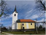 | Pristavlja vas - Lavričeva koča on Gradišče
Lavričeva koča (510 m) is located just a few meters below the summit of Gradišče (519 m), where the Church of St. Nicholas stands. From the summi...
30 min |
 | Ponikva pri Žalcu - Apno
Apno is a 525-metre-high mountain located on the Ponikovski karst. The summit has some benches, a summit register box, but due to the forest ther...
30 min |