Starting point: Komare doline (297 m)
| Latitude/Longitude: | 45,4969°N 13,8867°E |
| |
Walking time: 35 min
Difficulty: easy marked way
Elevation gain: 154 m
Elevation difference along the route: 160 m
Map: Slovenska Istra - Čičarija, Brkini in Kras 1:50.000
Recommended equipment (summer):
Recommended equipment (winter):
Views: 4.638
 | 1 person like this post |
Access to starting point:
From the highway Ljubljana - Koper we go to the exit Črni Kal. From Črni Kal we continue driving on the old road towards the coast, but we drive along it only to the next somewhat larger intersection, where we turn left in the direction of the border crossing Sočerga. On the mentioned road, we drive past the settlement Kubed to the village Gračišče, where at the intersection we turn left in the direction of Rakitovec, Movraž and Smokvica. From Gračišče we drive approximately 800 m, then by the road we notice the blazes and the sign on the rock for Lačna, which direct us to the left. Here we park in an appropriate place by the road. The starting point is located approximately 50 m before the next smaller intersection.
To the starting point we can also come from the direction of the coast, namely through the settlements Prade, Pobegi, Čežarji, and Sveti Anton.
Route description:
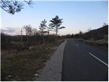
From the starting point, we head onto the marked footpath in the direction of Lačna. The path first crosses a quite overgrown meadow, then joins a wider cart track, along which we continue. At the junctions, we follow the blazes, and the cart track higher up changes into a somewhat steeper and in several places also overgrown mountain path. Higher up, some views open onto the surrounding hills, and the path a little further brings us to the ridge of Lačna, where we also step onto a wide cart track.
We follow the cart track to the left (right Vrh križa, Krog, Kuk, Gradež, Slavnik...) which leads us in a gentle ascent across partly grassy slopes. After a few minutes, the blazes from the cart track direct us to the right onto a marked path, along which we quickly arrive at the top of Lačna.
From the top, we can also climb to the lookout tower, from which a nice view opens towards Slavnik, Učka, Gulf of Trieste, and in good weather all the way to the Dolomites and Julian Alps.

Photos:
 1
1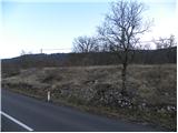 2
2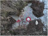 3
3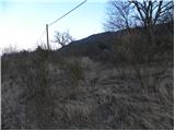 4
4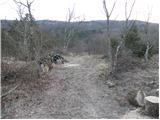 5
5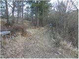 6
6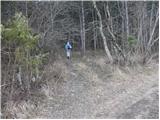 7
7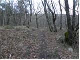 8
8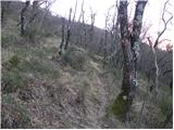 9
9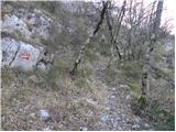 10
10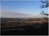 11
11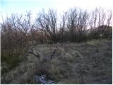 12
12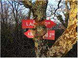 13
13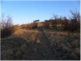 14
14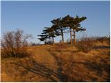 15
15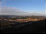 16
16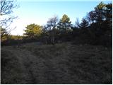 17
17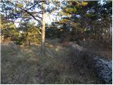 18
18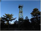 19
19 20
20
Discussion about the trip Komare doline - Lačna
|
| Kigeot6. 02. 2015 |
End of January we went along this path and at the beginning it wasn't easy to find the right path. The marker in picture 3 is completely snow-covered, you can't see it from the car at all, you have to find it on foot.
My "instructions" I wrote directly on the blog:blog: Komare Doline - Lačna
|
|
|
|
| Isonja31. 10. 2022 10:12:38 |
We went on this path at the end of October 2022. I think it would be better if the path sign said "easy unmarked path", as the condition is even worse than reported by Kigeot. The path is at least in the first half very overgrown, the markings are mostly completely faded or only a small piece remains because the rest has peeled off the bark. Like Kigeot, I warn about the start of the path. It is still quite visible from the road, as there is now a sign on the power pole, but when you park and head to the path, you might be misled by the signs and go along the visible cart track, which is wrong. Actually, you have to go right of this cart track, through the bushes and trees, as the path is overgrown. The orientation is that you quickly reach the (abandoned?) shooting range. We went left along it, but didn't find any marking where to turn into the forest and uphill, so we went by feel and a bit higher in the forest we really stumbled upon a trail, which several times looked overgrown and we continued by feel again. Only around there as shown by pictures 9 and 10 is the trail clearly visible. But as a reward for persistence, we had a very nice view all the way to the sea and wonderful colors of autumn foliage.
|
|
|
To post a comment you must log in:
If you do not yet have a username, you must first
register.