Becherhaus - Zuckerhütl (via Wilder Pfaff and the V slope (II+/I-II))
Starting point: Becherhaus (3195 m)
| Lat/Lon: | 46,961°N 11,19268°E |
| |
Name of path: via Wilder Pfaff and the V slope (II+/I-II)
Time of walking: 4 h
Difficulty: very difficult marked way
Altitude difference: 312 m
Altitude difference po putu: 312 m
Map: Stubaier Alpen Hochstubai, 31/1 1:25.000; Outdooractive Stubai Wanderkarte
Recommended equipment (summer): helmet, ice axe, crampons
Recommended equipment (winter): helmet, ice axe, crampons
Views: 844
 | 2 people like this post |
Access to the starting point:Iz Ljubljane se zapeljemo po avtocesti mimo Salzburga v smeri proti Münchnu. V večnivojskem križišču Dreieck Inntal se usmerimo na cesto A93 v smeri Innsbruck/Kufstein/Brenner. Ob vrnitvi v Avstrijo nadaljujemo do razcepa z izvozom Innsbruck-Mitte. Tu ne zavijemo proti Innsbrucku, temveč nadaljujemo po avtocesti A13 v smeri proti prelazu Brenner. Z avtoceste zavijemo pri izvozu 10-Schönberg in udobni cesti po Stubajski dolini sledimo do krajev Neustift im Stubaital, središča Stubajske doline, in Volderau, kjer se še vedno široka asfaltna cesta prične nekoliko izraziteje vzpenjati v smeri Mutterbergalm in smučišča Stubaier Gletscher. Kmalu na levi zagledamo velik slapa Grawa in parkirišče pri istoimenski mountain pasture; tu je prvo izhodišče za vzpon proti Sulzenauhütte. Po nekaj minutah nadaljnje vožnje parkiramo na precej prostornem namenskem parkirišču, ki nam omogoča najlagodnejši pristop h koči, in kjer pri izhodišču opazimo veliko informativno tablo s poudarkom na vzponu k Sulzenauhütte.
Do koče Becherhaus sledimo poti, ki preči pod vrhom Wilder Freiger (glej opis vzpona proti koči:
http://www. hribi. net/izlet/parkirisce_sulzenauhutte_becherhaus_mimo_sulzenauhutte_in_preko_sedla_seescharte/51/3381/8129) Alternativo ponuja vožnja skozi severno Italijo: v tem primeru se iz osrednje Slovenije po avtocesti A2 zapeljemo do enega izmed mejnih prehodov z Avstrijo in nadaljujemo pot do Lienza. Tu nadaljujemo po cesti 100 in se mimo prehoda Prato alla Drava zapeljemo v Italijo. In Itali, follow the SS49 all the way to the junction with the A22 motorway in the direction of the Brenner Pass. After the pass, continue in the direction of Innsbruck to the Schönberg exit. From there, follow the route described above.
The hut can be reached more quickly from the Ridnauntal valley in Itali, but in this case it would be advisable to return only by the route described above, which is even more difficult on the descent.
Path description:
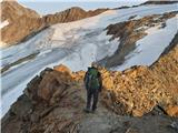
From the hut, descend the ridge leading to Wilder Freiger and further into the Stubajska valley. After a few minutes of descending the carved steps, at the foot of the Becherfelsen escarpment, turn left onto the path that turns sharply down towards the Übeltalferner glacier. The steep but short descent to the glacier is aided by a ropeway and a few steps.
At the edge of the glacier, prepare to cross the glacier in the direction of the clearly visible Müller Hütte and the east ridge Wilder Pfaff to the west of it; orientation is difficult in the fog.
In high season, gauzes will help us cross the glacier, but there are usually several of them - it is better not to get too low and to follow the tracks, which are occasionally confirmed by marker sticks. The glacier is cracked in places, but the holes are visible and usually marked.
Below the rock mass hosting the Müller Hütte, first turn slightly south, then cross south under the wall of the connecting ridge between Wilder Freiger and Wilder Pfaff to a favourable passage to a ridge about 200 long metres west of the lowest point of the ridge. The most favourable approach to the ridge will normally be guided by steps.
At a suitable point, climb steeply over crumbly rubble to the ridge cut and follow it westwards. As long as you have not approached too low, you will soon come across signs which will lead you continuously from then on to the summit. Warning: up to the point where the markers appear, the ridge is quite uneven and distinctly crumbly, so it is wise not to approach it too early.
After crossing a small rise in the ridge, the ridge descends slightly on a rather crumbly terrain, which requires caution. It then widens out a little and offers some quite attractive grade I climbing with a few short grade II places. This leads to a spot marked with a stick and/or a big man somewhere in the middle of the route. After that the ridge is much more upright and the rock is better.
The ridge is more difficult in the upper part, but there are several anchorages which allow a fairly reliable belaying. Shortly after crossing the stone blocks on the route, we find ourselves in front of a key spot: a steep, exposed but short jump, which reaches a high grade II. After it, the only conventional fixed safety gear on the route - a rope and steps - help us over an inclined slab. To the top, there is a less demanding but in places airy scramble along and south of the ridge cut. The ascent along the ridge usually takes 1-1. 30 h.
From Wilder Pfaff descend an easily traversable slope to the (north)west. After a short glacial traverse, a modest path leads over a generally steep slope in high season to the lowest point between Wilder Pfaff and Zuckerhütl, the Pfaffensattel saddle (easy, but crumbly).
Just above the saddle, we join the glacier trail (gaz), which, like the route of the normal trail on Zuckerhütl and Wilder Pfaff, comes here from the west. From the saddle, to the right of the precipitous edge, it takes a few minutes to climb to the base of the rocky summit of Zuckerhütla. Here it is a good idea to put your rucksack down before the challenging final climb.
The climb up the eastern face of Zuckerhütl is short, but the precipitous, crumbly terrain exposes it to natural changes and is objectively quite dangerous, especially if there are other hikers climbing above us. The optimal course of the route is somewhat dependent on the prevailing conditions, although individual markings and drill marks are used for orientation, allowing us to belaying at tricky spots.
From the foot of the rocky slope, first ascend over unstable scree, then traverse slightly southwards. After a short exposed traverse, climb to the slightly flatter terrain below the summit at a suitable passage. Following the markers and anchor points, climb over a steep steel cable and cross an easier-to-traverse summit to reach a small but very exposed summit with a large crux.
The East Ridge Wilder Pfaff is an easier, short and quite popular climbing route. The climbing is mostly Grade I with a few Grade II places; the ridge is not too airy except in parts, but it is quite crumbly in places, so it requires constant concentration and careful pacing. In the most difficult places, a well-equipped route allows for a proper belaying, and a few metres of rope over an awkwardly sloping slab also helps.
The final ascent of Zuckerhütl is a short but potentially quite tricky affair, especially so on busy days. The climbing does not go beyond grade II, but the route is precipitous in places and the rock is very crumbly. Zuckerhütl is also the highest point of the popular "7 summits of Stubai" route. For the less experienced, I recommend belaying with a rope or accompanied by a mountain guide.
Insofar as we approached Becherhaus from the Stubai Valley in Austria, I recommend a much easier and shorter route for the return, which descends from the base of Zuckerhütl towards Pfaffensattle and crosses the Sulzenauferner glacier to the west, and then descends towards the Fernaujoch Pass. From there, you can continue to the Schaufeljochbahn and take it down to the lower cable car station at Mutterbergalm, or you can walk down to the latter via the "Stubaier Gletscher" ski area and past the Dresdner Hütte. From the lower cable car station, it's about half an hour downhill on a pleasant forest path to the starting point.

Pictures:
 1
1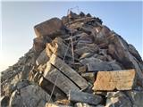 2
2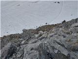 3
3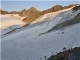 4
4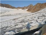 5
5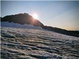 6
6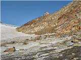 7
7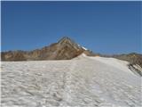 8
8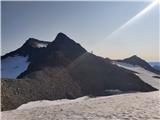 9
9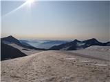 10
10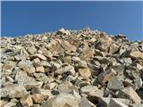 11
11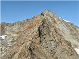 12
12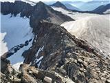 13
13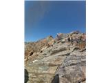 14
14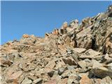 15
15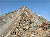 16
16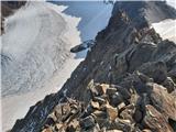 17
17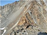 18
18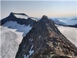 19
19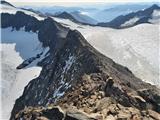 20
20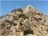 21
21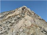 22
22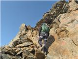 23
23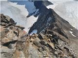 24
24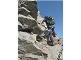 25
25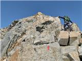 26
26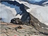 27
27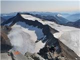 28
28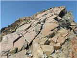 29
29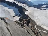 30
30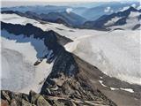 31
31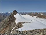 32
32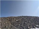 33
33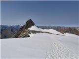 34
34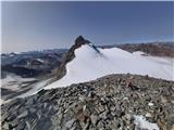 35
35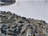 36
36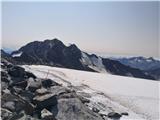 37
37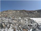 38
38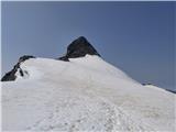 39
39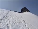 40
40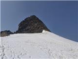 41
41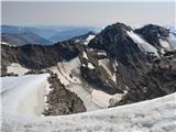 42
42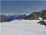 43
43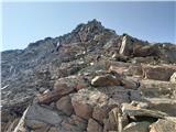 44
44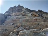 45
45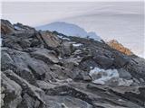 46
46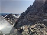 47
47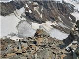 48
48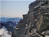 49
49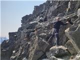 50
50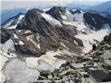 51
51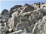 52
52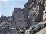 53
53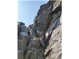 54
54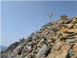 55
55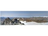 56
56
Discussion about the trail Becherhaus - Zuckerhütl (via Wilder Pfaff and the V slope (II+/I-II))