|
| Laščan29. 07. 2013 11:24:46 |
A week ago we drove by car to planina Zaprikraj. Car more "low" than "high", no problems at all. Otherwise very beautiful around Krasji vrh, Debeljak and arranged open-air museum.
|
|
|
|
| B229. 07. 2013 11:37:33 |
Thanks to both for useful info.
Nice day to you!
|
|
|
|
| Edina19. 09. 2014 12:35:10 |
On the best weather forecast for western Slovenia on Wednesday to Krnčica from Lepena, past Krnsko jezero, to the saddle Čez potoče, from there first to Griva and Skutnik, then to the foggy peak of Krnčica. Return towards Krnska škrbina and descent back towards planina Na polju and Krnsko jezero. Very nice loop trip. Unfortunately foggy despite different forecast, undoubtedly worth the effort. Will repeat and expand a bit in nice weather. Safe travels, more and also the route track in the blog post.
http://stezeinsledi.blogspot.com/2014/09/krncica.html
| (+9) |  | |
|
|
|
|
| green30. 08. 2015 17:25:23 |
Can someone please advise how to get to Griva (1997m) with route description and how difficult it is. Interested because of Soča front.
Thanks for help
|
|
|
|
| taubi48. 11. 2015 20:48:25 |
Today we went from Zapleč pasture to Krnčica and Srednji vrh. We left the pasture at 8:05, so we went to the top of Krnčica in the shade. From Vrata onwards we ascended the ridge with light scrambling. The ridge traverse from Krnčica to Srednji vrh would be even easier if there wasn't a four-meter jump in between worth a good II.
Weather fantastic, even too hot. At the pasture at two it was 21 degrees Celsius, and that's on November 8th.
I'm wondering from when this path is marked and to where.
|
|
|
|
| jprim6. 07. 2016 21:32:48 |
Yesterday's excursion in this area was gorgeous. To find yourself in a solitary world, meaning no one except shepherds on the pasture, is pure peace for the soul. Numerous remnants from WWI and beautiful views all around, that is - 360 degrees.
Only if the drive weren't so long, but once you're at the top you forget about the very early wake-up.
And safe steps.
| (+5) | | |
|
|
|
|
| Trobec14. 01. 2019 20:55:40 |
Should add a subtitle "not quite to the top". But more on that later.
On Sunday (actually decision made on Saturday) I quickly decide for Lopatnik and Krnčica. Given the fairly short tour I didn't start very early. Still, I was first at Zapleč pasture. 2 more arrive soon after me, while I'm already huffing uphill, but both head in another direction. Maybe towards Krasji vrh.
First snow starts high. Only just below the ridge. On the path itself a bit earlier. To Oblo brdo and Lopatnik possible without winter gear. Further along the ridge towards Krnčica the snow is harder, even icy. Higher up softer and unconsolidated again. Given some rock climbing, I was already pondering whether to take off crampons again. After the forepeak of Krnčica over another slightly harder section and I reach a fairly fresh track (probably yesterday's). I follow it for a while as it crosses slopes (fall not an option here!), at one particularly exposed part (no, actually I didn't want to cross it), I start thinking the path goes too far around, it should go higher. And I turn back. Correctly, soon I find the marked path again going to the ridge. When it looks like I'm almost right at the top, just seconds not minutes away, new surprise. Short very narrow section loaded with not well consolidated snow. I didn't think long, won't test the holding power of that snow flank on a section looking almost like walking a tightrope, precipice on both sides.
I descended on my predecessor's track. Don't know, maybe better to go back the ascent path. Still quite a few exposed sections and it took some time before I could relax concentration.
Well, Krnčica isn't some easy winter tour anyway.
 1 1 2 2 3 3 4 4 5 5 6 6 7 7 8 8 9 9 10 10 11 11 12 12 13 13 14 14 15 15 16 16 17 17 18 18 19 19 20 20 21 21 22 22 23 23 24 24
| (+6) | | |
|
|
|
|
| Parkeljc5. 07. 2019 22:35:12 |
We headed to Krnčica on Monday 1.7.2019. The "road" is really really beaten up. Last year we started from planina Zapleč towards Krasji vrh and it was in similar condition. This time we didn't fall for it (fatal), but I advise really slow and careful driving. I think the road is in worse condition than last year. Well, the car survived, phew.. but really slowly..  . By the way, most adrenaline we "released" driving to and from planina Zapleč. Well, even from the end of asphalt, but on foot . By the way, most adrenaline we "released" driving to and from planina Zapleč. Well, even from the end of asphalt, but on foot  . Anyway, we start from the parking lot directly to the saddle. Goal was just Krnčica, but we extended the goal considerably.. We reached that without issues, so we threw in Skutnik and Lopatnik too,.. Turned out after half an hour of occasional scrambling we ended up on Srednji vrh. We return to Krnčica. We look towards Skutnik, but it didn't appeal, so casually we "visit" Lopatnik. Somewhere we noticed the path continues towards Oblem brdu and Vršič,... So we went. The path really dragged on, occasionally disappeared and reappeared. We knew there's an old mule track between Oblim vrhom and Vršič; finally we caught it and exactly at the WWI ruin we take it in switchbacks down towards Zaprikraj. Roughly to halfway the mule track was traceable, then... . Anyway, we start from the parking lot directly to the saddle. Goal was just Krnčica, but we extended the goal considerably.. We reached that without issues, so we threw in Skutnik and Lopatnik too,.. Turned out after half an hour of occasional scrambling we ended up on Srednji vrh. We return to Krnčica. We look towards Skutnik, but it didn't appeal, so casually we "visit" Lopatnik. Somewhere we noticed the path continues towards Oblem brdu and Vršič,... So we went. The path really dragged on, occasionally disappeared and reappeared. We knew there's an old mule track between Oblim vrhom and Vršič; finally we caught it and exactly at the WWI ruin we take it in switchbacks down towards Zaprikraj. Roughly to halfway the mule track was traceable, then...  .. Occasionally we take it directly, until outlines of the former mule track appear. Last half hour we descended only through tall grass, expecting to run over some snake. Luckily it didn't happen. Then just a walk past planina Zapleč and nearby cows lying on the road to the car, where ice-cold beer awaited us in the cooler bag. .. Occasionally we take it directly, until outlines of the former mule track appear. Last half hour we descended only through tall grass, expecting to run over some snake. Luckily it didn't happen. Then just a walk past planina Zapleč and nearby cows lying on the road to the car, where ice-cold beer awaited us in the cooler bag.
The path from planina Zapleč towards Vrata saddle is nicely traceable, occasionally need to concentrate, but generally no problems.
From Srednji vrh we see Krn full of tourists, not far away just us two, all the way to the car. And one refreshing info, between planine Zaprikraj and Zapleč crystal clear ice-cold (drinkable) water flows from who knows where, you simply can't pass by without drinking it 
 1 1 2 2 3 3 4 4 5 5 6 6 7 7 8 8 9 9 10 10 11 11 12 12 13 13 14 14 15 15 16 16
| (+5) | | |
|
|
|
|
| ljubitelj gora19. 08. 2019 09:07:29 |
Afternoon to Lopatnik and further along the ridge to Krnčica.
| (+1) | | |
|
|
|
|
| darinka413. 10. 2019 07:51:50 |
Picture 30 shows Skutnik.
|
|
|
|
| haridautovic13. 10. 2019 12:44:08 |
5.10.2019-This time we set out to finish what we couldn't in winter, this time we had to turn back below the top of Krnčica due to bad winter conditions, today (though not an ideal day for such a ridge, probably also because of historical events, it hid in clouds all day) we went anyway. Not at all disappointed by weather, views or wind, except by everything we saw on today's hike. At every step signs, pictures and images 100 years old still witnesses to the cruel fate of all involved in the bloody and senseless war that has no excuse. History should teach us not to repeat. But I always feel that history intends to repeat itself UNFORTUNATELY. From Zapleč pasture along the marked mule track under Vrata saddle right to the top of Krnčica, from the top trenches, bunkers and taverns between Krnčica, Srednji vrh and Lopatnik catch our eye, so we continued to Srednji vrh and shortly after descent along military trenches under the foot of Srednji vrh and Krnčica. We just marveled and silently observed all that people did in those times. We continue along the well-preserved stone mule track and trenches towards Lopatnik which is full of taverns and bunkers,,unbelievable,,,,descent into some kind of basin and exit to Vrata saddle from where we continue along the ridge towards Vršič. In the middle of the ridge, due to dew we descend along unmarked mule track back to start. Just to mention, we didn't see Krn at all today obviously the weather here adjusts to history and past,,pure grayness.
 1 1 2 2 3 3 4 4 5 5 6 6 7 7 8 8 9 9 10 10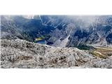 11 11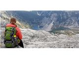 12 12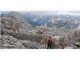 13 13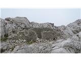 14 14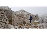 15 15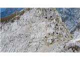 16 16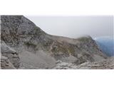 17 17 18 18 19 19 20 20 21 21 22 22
| (+1) | | |
|
|
|
|
| miri13. 10. 2019 12:52:07 |
adjusts to history and past,,pure grayness.
Maybe I should visit it at night.
 1 1
| (+1) | | |
|
|
|
|
| ales5013. 10. 2019 17:53:35 |
It's already nicely visible in the snow
|
|
|
|
| Sorok12. 07. 2020 22:08:27 |
In the morning from planina Zapleč along the mule track to Krnčica, Srednji vrh and on the way back also to Lopatnik.
Weather sunny, some fog was also "rolling", in the forenoon still strong and cold wind, so that I had winter gloves for some time... Trail OK, it surprised me that it is now nicely marked - when I was there a few years ago, there were no such marks. I met only 4 hikers.
Well, despite that cold in the morning, really nice tour
| (+3) | | |
|
|
|
|
| djimuzl26. 10. 2021 11:34:08 |
Uh, nice
Beautiful pentagram on No. 23
| (+2) | | |
|
|
|
|
| lijaneja26. 10. 2021 12:46:33 |
It reminds me more of the former SAP Kosovo. (90% accuracy of the outline of that still unrecognized Balkan country)
| (+1) | | |
|
|
|
You must log in to post a comment:
If you do not yet have a username, you must first
register.