Korošica via Šraj pesek and Najnar štant
|
| velkavrh27. 04. 2011 21:15:26 |
Calling experienced mountaineers who know these two unmarked paths to Korošica to describe the start of the path, because both guidebooks like Stritar's or Habjan's don't get me to Skok. I tried two years ago, got lost and even got injured on the way back. This week I explored the path again. I decided to go to Najnar štant, which bypasses Skok and is recommended for descent. I went towards Presedlaj and at the second left junction took that path. It was well trodden and led me across a small ravine to the other side. Then the path went along the right side above the stream bed, crossed it, led me back to the right bank. From there it went a bit steeper, on the right side I spotted a natural window - quite big, and higher up on the same side there were some cliffs visible in the rocks. I walked an hour and a half from the start to here. But the path was no longer visible. There was a lot of leaves on the ground though. I decided to turn back. On the way back, at the waterfall I met a hiker who said it was the path to Skok. He was also returning via Najnar štant. I'm interested if I went correctly to that window and how to continue to Skok. Skok is no problem for me, as I have climbing experience. I've already climbed for example Mrzla gora, Rjavina from Kot, Šklatica and similar. Already two years ago Marko and Robin advised me, maybe add something this time too, even in private messages. I recommend myself and thanks in advance!
|
|
|
|
| Volk27. 04. 2011 21:51:33 |
Well the guidebooks aren't written so 'off', mate.
The unmarked trail through Kamendol is found quickly at the waterfall (before Orglice waterfall) if you know where to look.  Following it isn't any big deal either (the one over Najnar štant is a bit harder). Following it isn't any big deal either (the one over Najnar štant is a bit harder).
Given you got injured there once, I'd recommend next exploration with an expert companion. On climbing ...
At that Skok quite some things happened, even though it looks very harmless from below and even equipped with some pegs that help little in the upper hardest part. It's II degree climbing, can't compare to mentioned marked paths! But above it there's nicely set anchor for rope descent.
Cheers.
| (+1) |  | |
|
|
|
|
| Irina27. 04. 2011 22:46:47 |
Velkavrh, why not just write directly to Andrej Stritar on FB? As far as I know him, he's a very friendly guy and will probably reply or help you get to the desired Skok.
|
|
|
|
| LidijaJesih23. 09. 2011 16:39:26 |
I hope you've already found the path over the skok, otherwise check my description under Lučki dedec.
Wolf, shame that all archives went to the PZS forum (at least it seems so). There was a lot written there, these two paths also caught my "eye" 
|
|
|
|
| velkavrh23. 09. 2011 23:18:34 |
This path is a shortcut to Korošica. I'll probably try it this year according to your description. Otherwise I went to Ojstrica or rather to Korošica from Robanov kot and it was great, over 400m of cables and 400 pegs! Extremely nice secured path!
|
|
|
|
| jarsan24. 09. 2011 10:23:17 |
Andrej Stritar describes this path in the book "Grintovci - Southern approaches" like this: "Below the outflow of Orglic, a clogged gully descends from below Rzenik from the right. We follow the path to the right of it approx. 50m upwards, then cross the gravelly gully." So not below, but above the Orglice waterfall. The path is well trodden, to Skok another path joins from the right, from it a path to Kamniška jama branches left. The path over Najnar štant branches from the path to Presedlaj at around 1000m (Orglice waterfall 782m).
|
|
|
|
| nk24. 09. 2011 11:27:35 |
If you go over Najnar štant, you bypass the skok, as the paths join a bit above it and then the common path continues over the Šraj pesek scree to Petkove njive and Korošica. That's exactly the advantage of this path over Najnar štant. But it's true that this "path" in the second part from the štant onwards is not beaten and has more like off-trail characteristics, where you need some sense of orientation. If you catch the right "path", no major technical difficulties, but if some chamois trail leads you astray, you can end up in impassable terrain.
 1 1
| (+1) | | |
|
|
|
|
| LidijaJesih24. 09. 2011 18:06:28 |
@jarsan: yes Stritar writes that, but all happens below the waterfall, not above it. If you look for it above you won't find it. For help step by step pics from the junction with the marked path.
| (+1) | | |
|
|
|
|
| mero552. 04. 2012 14:13:06 |
Jarsan is right, at the junction to the waterfall you continue 30 meters to the right along the gully and only then cross it on a well visible path. Then you climb steeply through the forest. The path leads along Kamendol past nice pools to the cliffs called Skok, which you should bypass on the left.
|
|
|
|
| LidijaJesih2. 04. 2012 15:09:34 |
The pics are one post higher.. and instructions below them...
And checked, that's how you go and come back right. Skok is quite a bit higher though.
and if grandma doesn't get lost, then men with orientation aren't hard either.
| (+2) | | |
|
|
|
|
| jarsan2. 04. 2012 16:39:47 |
I myself have walked this path several times and always crossed the torrent gully into which the waterfall flows a few dozen meters further from the waterfall.
|
|
|
|
| SilvestrO2. 04. 2012 17:56:03 |
If I'm a bit ironic too,... everything happens below the waterfall..., wrongly said or,... granny logic  , ,
...everything happens after the path to the waterfall branches left, we continue in the same direction...etc,etc,... Skok is of course in the cirque of Kamendola...
From the path to Presedlaj to Šraj pesek there are upper and lower hunting paths,... one of them is over Najnar štant...
| (+2) | | |
|
|
|
|
| jožka14. 04. 2012 18:52:10 |
Among numerous loops and puzzles of the forum heroes there is also the path over Najnar štant.
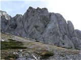
I went to unravel it today, since the weather was perfect for exploring. I went up via Skok and above it on scree right up under the wall as I knew I'd eventually run into it. I found it right under the wall and continued up it, as I was curious where the beginning - lengthwise - splits from the path over Šrajpesek and Skok.
So: When descending through the little woods under the Vežica wall, on one of the left zigzags the path gets right up to the wall, and cairn, faded arrow and sign ''hunting path'' directs you down and left into smoothed gully. From here it's always visible, 2/3 times a little climb and after numerous traversals of gullies, descents and ascents you join the path from Presedlaj. In between you hit some ''hunting'' peg, a couple rickety cairns and a bunch of game trails that lure you into dead ends.
Going up there are probably fewer complications, the split is behind a bigger rock(with today's newborn cairn)- left along the path to Presedlaj, on the right unmistakable sawn-off tree root.
The path over Najnar štant is quite longer and more awkward than over Skok and whoever isn't up to Skok won't feel good on the hunting one either, knowledge from various ferratas won't suffice here. Your Jožka
| (+6) | | |
|
|
|
|
| pika4. 06. 2012 08:04:08 |
Lidija, your description of the path under Lučki dedec is really precise and at the same time simple and you can't miss orientation-wise . About the difficulty of the path itself a lot has already been written above, so let each judge for themselves how and what.
Best regards!
| (+2) | | |
|
|
|
|
| trilko11. 06. 2012 13:56:27 |
I've been tempted by Korošica via Skok and Šraj pesek for a while, yesterday I used the day for terrain scouting and to find this ominous Skok at all
No problem finding velb (arch), then you need to climb a bit more and you reach the rocks. Every now and then a "cairn" appears somewhere. But I didn't tackle Skok itself, will need to come with someone more experienced... Hope sometime this year
| (+1) | | |
|
|
|
|
| garmont11. 06. 2012 21:55:47 |
Of course it's the real one. Right from the start you need to use all limbs quite a bit. For easier start there's a jammed stone in the nicely visible gully in the middle, from there on friction.
Regards
 1 1 2 2
|
|
|
|
| dprapr23. 11. 2012 09:40:13 |
Vežica is really something special, especially its wall. Compact, like the walls in Paklenica!
Is this approach gully to the ridge already in Vršiči, above the scree? Near that nice Lukman route?
Skok is really smooth, and the old pegs are unusable too. But the stance is exemplary well arranged! Last time there after many years descending again, I was just thinking that it wouldn't be good to be without rope if wet!
Regards
| (+2) | | |
|
|
|
|
| garmont23. 11. 2012 19:46:53 |
This is the second big gully from the Šraj pesek direction (exactly above the big cairn that marks the path to Petkove njive). I entered on the right side over a nicely visible jump (cairned entry is on the left). The gully is only at the beginning, later it turns into a wall with lots of good holds and brings you to the ridge.
| (+2) | | |
|
|
|
|
| dprapr23. 11. 2012 21:09:49 |
Thanks, garmont!
I didn't know this passage exists. Usually I descended there before Dedec!
If I understand correctly, this is on the left side of my picture?
 1 1
|
|
|
You must log in to post a comment:
If you do not yet have a username, you must first
register.