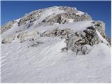
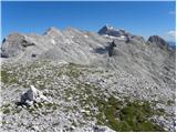
 | Planina Blato - Zadnji Vogel (snowy approach)
The mountain is located between Debeli vrh and Zelnarice. From the top there is a beautiful view towards Kanjavac, Debele Vrh, Vršaki and Mala an...
4 h 15 min |
 | Planina Blato - Vrh Hribaric (via Planina v Lazu and through valley Dolina za Debelim vrhom)
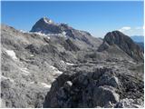
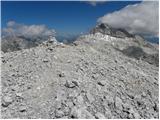
Vrh Hribaric is a 2388 m high mountain located between Vršaki, Kanjavac, Mišeljski Konec, Škednjovec and Debeli vrh. From the summit, on which st...
5 h |
| Planina Blato - Vrh Hribaric (via Planina Krstenica and through valley Dolina za Debelim vrhom)
Vrh Hribaric is a 2388 m high mountain located between Vršaki, Kanjavac, Mišeljski Konec, Škednjovec and Debeli vrh. From the summit, on which st...
5 h 15 min |
 | Planina Blato - Vršaki (Vrh za Koritami) (via Planina v Lazu and through valley Dolina za Debelim vrhom)
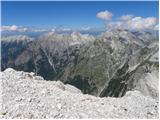
The peak behind Korite is a 2422 m high mountain rising steeply above the upper part of the Triglav Lakes Valley. The summit, which is an integra...
5 h 40 min |
| Planina Blato - Vršaki (Vrh za Koritami) (via Planina Krstenica and through valley Dolina za Debelim vrhom)
The peak behind Korite is a 2422 m high mountain rising steeply above the upper part of the Triglav Lakes Valley. The summit, which is an integra...
5 h 55 min |
 | Planina Blato - Vršaki (Srednji vrh) (via Planina v Lazu and through valley Dolina za Debelim vrhom)
The middle peak Vršaki is a less distinct peak located between eastern and western Vršak. From the top, we have a beautiful view of Debeli vrh, t...
5 h 20 min |
| Planina Blato - Vršaki (Srednji vrh) (via Planina Krstenica and through valley Dolina za Debelim vrhom)
The middle peak Vršaki is a less distinct peak located between eastern and western Vršak. From the top, we have a beautiful view of Debeli vrh, t...
5 h 35 min |
 | Planina Blato - Vršaki (South peak) (via Planina v Lazu and through valley Dolina za Debelim vrhom)
South Peak Vršaki is the southernmost peak in the little-visited Vršak ridge. The summit, on which stands the smaller cairn, offers a beautiful v...
5 h 50 min |
| Planina Blato - Vršaki (South peak) (via Planina Krstenica and through valley Dolina za Debelim vrhom)
South Peak Vršaki is the southernmost peak in the little-visited Vršak ridge. The summit, on which stands the smaller cairn, offers a beautiful v...
6 h 5 min |
 | Planina Blato - Vršaki (Vzhodni vrh) (via Planina v Lazu and through valley Dolina za Debelim vrhom)
The eastern peak Vršaki, or the first of Hribarice, is a 2448 m high mountain located between Kanjavec, Debeli vrh and Zadni Vogel. From the top,...
5 h |
| Planina Blato - Vršaki (Vzhodni vrh) (via Planina Krstenica and through valley Dolina za Debelim vrhom)
The eastern peak Vršaki, or the first of Hribarice, is a 2448 m high mountain located between Kanjavec, Debeli vrh and Zadni Vogel. From the top,...
5 h 15 min |
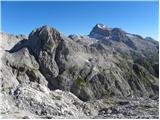
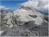
 | Planina Blato - Teme (Hribarice) (via Planina v Lazu and through valley Dolina za Debelim vrhom)
Teme is a less distinct peak located between Kanjavac and Poprovac. This little-visited peak offers views, in good weather, all the way to the It...
6 h 5 min |
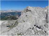
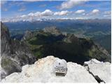
 | Planina Blato - Kanjavec (via Dolina za Debelim vrhom)
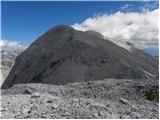
Kanjavec is a 2569 m high mountain located between Dolič and Hribarice. From the top, which has a registration box and a stamp, we have a beautif...
5 h 45 min |
 | Planina Blato - Kanjavec (via Planina Krstenica and through valley Dolina za Debelim vrhom)
Kanjavec is a 2569 m high mountain located between Dolič and Hribarice. From the top, which has a registration box and a stamp, we have a beautif...
6 h |
 | Planina Blato - Kanjavec (West peak) (via Planina v Lazu and through valley Dolina za Debelim vrhom)
The western peak of Kanjavac is a 2569 m high mountain that descends precipitously towards the valley of the Zadnjica. From the top, we have a be...
5 h 45 min |
 | Planina Blato - Kanjavec (West peak) (via Planina Krstenica and through valley Dolina za Debelim vrhom)
The western peak of Kanjavac is a 2569 m high mountain that descends precipitously towards the valley of the Zadnjica. From the top, we have a be...
6 h |
 | Ponte de Ru Curto - Monte Formin (via Rifugio Croda da Lago)
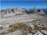
Monte Formin is a 2,657-metre-high pathless peak in the Italian Dolomites. The peak is popular with climbers, but its gentle eastern slopes also ...
3 h 45 min |
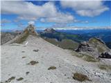 | Lech da Sompunt - Muntejela de Puez (path 11)
Muntejela de Puez is a 2,666-metre-high peak located in the Puez-Odle Natural Park in the Italian Dolomites. From the top, you can enjoy a very n...
4 h 10 min |
| Lech da Sompunt - Muntejela de Puez (path 15)
Muntejela de Puez is a 2,666-metre-high peak located in the Puez-Odle Natural Park in the Italian Dolomites. From the top, you can enjoy a very n...
5 h |
| Colfosco - Muntejela de Puez
Muntejela de Puez is a 2,666-metre-high peak located in the Puez-Odle Natural Park in the Italian Dolomites. From the top, you can enjoy a very n...
3 h 45 min |
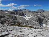 | Lech da Sompunt - Ciampani
Ciampani is a 2,668-metre peak in the Puez mountain group in the Italian Dolomites. The summit, on which the cairn is placed, offers a very nice ...
3 h 50 min |
 | Carbonin - Helltaler Schlechten
Helltaler Schlechten is a 2,711-metre-high peak located in the Fanes Sennes Prags Natural Park. There is no trail leading to the summit, but the ...
3 h 50 min |