 | Bukovnik - Velika Raduha (via Durce)
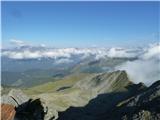
At 2062 m, Velika Raduha is the highest peak of Raduha, a mountain range rising steeply to the east of Robanov Kot. From the summit, which has a ...
2 h 50 min |
 | Planina Vodol - Velika Raduha
At 2062 m, Velika Raduha is the highest peak of Raduha, a mountain range rising steeply to the east of Robanov Kot. From the summit, which has a ...
2 h 40 min |
 | End of road on Vogar - Mala Tičarica (via Štapce)
Mala Tičarica is a very scenic mountain above the Double Triglav Lake. From the top, you can enjoy a beautiful view towards the cottage at Trigla...
3 h 35 min |
 | Dom na Gospincu - Kalški greben (via Dolga Njiva)
Kalški greben is 2224 m high and is the highest peak of the eponymous ridge. The summit, which has a registration box and a stamp, offers a beaut...
3 h 20 min |
 | Planina Podvežak - Veliki vrh (Veža) (via Prag)
Velika vrh is a 2110 m high mountain located in the central part of the Dleskovška plateau. From the top of the peak, where there are two registr...
2 h 20 min |
 | Planina Ravne - Veliki vrh (Veža) (via Zelene trate)
Velika vrh is a 2110 m high mountain located in the central part of the Dleskovška plateau. From the top of the peak, where there are two registr...
2 h 15 min |
| Planina Ravne - Veliki vrh (Veža) (via Dolga trata)
Velika vrh is a 2110 m high mountain located in the central part of the Dleskovška plateau. From the top of the peak, where there are two registr...
2 h 30 min |
| Kraljev dol - Veliki vrh (Veža) (via Planina Vodole)
Velika vrh is a 2110 m high mountain located in the central part of the Dleskovška plateau. From the top of the peak, where there are two registr...
2 h 35 min |
 | Waldheim Hütte - Zirbitzkogel (Seetal Alps) (direct way)
At 2396m, Zirbitzkogel is the highest peak in the Seetaler Alps. The summit, on which stands a cross and a viewing platform, offers a beautiful v...
2 h 2 min |
| Waldheim Hütte - Zirbitzkogel (Seetal Alps) (via Wildsee)
At 2396m, Zirbitzkogel is the highest peak in the Seetaler Alps. The summit, on which stands a cross and a viewing platform, offers a beautiful v...
3 h 22 min |
| Winterleiten parking - Zirbitzkogel (Seetal Alps)
At 2396m, Zirbitzkogel is the highest peak in the Seetaler Alps. The summit, on which stands a cross and a viewing platform, offers a beautiful v...
2 h 17 min |
 | Tonnerhütte - Zirbitzkogel (Seetal Alps)
At 2396m, Zirbitzkogel is the highest peak in the Seetaler Alps. The summit, on which stands a cross and a viewing platform, offers a beautiful v...
2 h 32 min |
 | Waldheim Hütte - Fuchskogel (Seetal Alps) (via Wildsee)
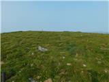
Fuchskogel is a peak south of Zirbitzkogel in the Seetaler Alps. The summit is vast and mostly covered with grass. More precisely, the summit is ...
2 h 30 min |
| Tonnerhütte - Fuchskogel (Seetal Alps)
Fuchskogel is a peak south of Zirbitzkogel in the Seetaler Alps. The summit is vast and mostly covered with grass. More precisely, the summit is ...
2 h 20 min |
 | Waldheim Hütte - Scharfes Eck (Seetal Alps) (direct way)
Scharfes Eck is the peak on which the Austrian meteorological radar station stands. The unpopular peak offers a beautiful view of the neighbourin...
2 h 30 min |
| Winterleiten parking - Scharfes Eck (Seetal Alps)
Scharfes Eck is the peak on which the Austrian meteorological radar station stands. The unpopular peak offers a beautiful view of the neighbourin...
2 h |
 | Tonnerhütte - Scharfes Eck (Seetal Alps)
Scharfes Eck is the peak on which the Austrian meteorological radar station stands. The unpopular peak offers a beautiful view of the neighbourin...
3 h |
 | Salzstiegelhaus - Weißenstein (Packalpe)
Weissenstein is a grassy mountain interspersed with wire fences. From its inconspicuous summit there is a fine view of the neighbouring Ameringko...
2 h 20 min |
 | Salzstiegelhaus - Ameringkogel (Packalpe)
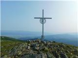
Ameringkogel is a grassy peak on which a cross is placed and on which a registration box is placed. At 2187m, it is also the highest peak in the ...
2 h 30 min |
 | Walischeben - Großenberg (Packalpe) (via Ameringkogel)
Großenberg is the northernmost of the two-thousanders in the Packalp chain. The vast grassy summit on which the triple cross stands offers a beau...
2 h 25 min |
| Walischeben - Großenberg (Packalpe)
Großenberg is the northernmost of the two-thousanders in the Packalp chain. The vast grassy summit on which the triple cross stands offers a beau...
2 h 20 min |
| Salzstiegelhaus - Großenberg (Packalpe) (via Ameringkogel)
Großenberg is the northernmost of the two-thousanders in the Packalp chain. The vast grassy summit on which the triple cross stands offers a beau...
3 h |
| Salzstiegelhaus - Großenberg (Packalpe)
Großenberg is the northernmost of the two-thousanders in the Packalp chain. The vast grassy summit on which the triple cross stands offers a beau...
2 h 55 min |
 | Jakobe - Petzen (Kordeschkopf) (Peca (Kordeževa glava)) (easy path)
Kordeževa glava, better known as Peca is the highest summit in the mountain chain Peca. It is located on the border with Austria above Mežiška do...
2 h 15 min |
 | Planina Ravne - Velika Zelenica (via Zelene trate)
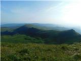
Velika Zelenica is the highest peak of the Dleskovská Plateau and the view is accordingly. The most beautiful is the nearby Ojstrica, below which...
2 h 15 min |
 | Planina Podvežak - Velika Zelenica (via Prag)
Velika Zelenica is the highest peak of the Dleskovská Plateau and the view is accordingly. The most beautiful is the nearby Ojstrica, below which...
2 h 30 min |
| Planina Ravne - Velika Zelenica (via Dolga trata)
Velika Zelenica is the highest peak of the Dleskovská Plateau and the view is accordingly. The most beautiful is the nearby Ojstrica, below which...
2 h 30 min |
 | Rosstratte - Dobratsch / Dobrač (by road)
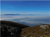
Dobratsch is a massive mountain range located west of Belgrade. Its highest peak is the 2166m-high Kuhriegel, which has taken the name Dobratsch ...
2 h |
 | Waldrast - Großer Speikkogel (Koralpe)
At 2140m, Großer Speikkogel is the highest peak of the Golice/Koralpe, a mountain range located east of Wolfsberg. From the top, where a cross an...
2 h |
 | Weinebene - Großer Speikkogel (Koralpe) (panoramic path)
At 2140m, Großer Speikkogel is the highest peak of the Golice/Koralpe, a mountain range located east of Wolfsberg. From the top, where a cross an...
3 h |
| Weinebene - Großer Speikkogel (Koralpe) (via Schäferkreuz)
At 2140m, Großer Speikkogel is the highest peak of the Golice/Koralpe, a mountain range located east of Wolfsberg. From the top, where a cross an...
3 h 15 min |
 | parking below Weinebene - Großer Speikkogel (Koralpe) (panoramic path)
At 2140m, Großer Speikkogel is the highest peak of the Golice/Koralpe, a mountain range located east of Wolfsberg. From the top, where a cross an...
3 h |
| parking below Weinebene - Großer Speikkogel (Koralpe) (via cross Schäferkreuz)
At 2140m, Großer Speikkogel is the highest peak of the Golice/Koralpe, a mountain range located east of Wolfsberg. From the top, where a cross an...
3 h 15 min |
| parking below Weinebene - Großer Speikkogel (Koralpe) (via Grünangerhütte)
At 2140m, Großer Speikkogel is the highest peak of the Golice/Koralpe, a mountain range located east of Wolfsberg. From the top, where a cross an...
3 h 10 min |
 | Waldrast - Großer Speikkogel (Koralpe) (ob robu planote Großes Kar)
At 2140m, Großer Speikkogel is the highest peak of the Golice/Koralpe, a mountain range located east of Wolfsberg. From the top, where a cross an...
2 h 45 min |
 | Lading - Ladinger Spitze (Saualpe) (via Ladinger Hütte)
Ladinger Spitze, or Ladinger Spitze in German, is the highest peak of the mountain pasture Sow/Saualpe at 2079m. From the summit on which the cro...
3 h |
 | Lading - Ladinger Spitze (Saualpe) (via Wolfsberger Hütte)
Ladinger Spitze, or Ladinger Spitze in German, is the highest peak of the mountain pasture Sow/Saualpe at 2079m. From the summit on which the cro...
2 h 45 min |
 | Klippitztörl - Ladinger Spitze (Saualpe)
Ladinger Spitze, or Ladinger Spitze in German, is the highest peak of the mountain pasture Sow/Saualpe at 2079m. From the summit on which the cro...
3 h 35 min |
 | Heidi Alm - Klomnock
Klomnock is the house mountain of the Nockalmstraße Alpine road, which leads to the Schiestelscharte Pass (2024m). From the summit on which the c...
2 h 15 min |
 | Turracher Höhe - Kaserhöhe
Kaserhöhe is a scenic peak located in Austrian Carinthia in the heart of the Krkonoše Alps. On the spacious peak, which is partly covered with gr...
2 h 20 min |
 | Passo Falzarego - Lagazuoi Piccolo (normal way)
Lagazuoi Piccolo is a 2778m high mountain located north of the alpine pass of Pso Falzarego (2105m). From the top where the cross stands, we have...
2 h 15 min |
| Passo Valparola - Lagazuoi Piccolo
Lagazuoi Piccolo is a 2778m high mountain located north of the alpine pass of Pso Falzarego (2105m). From the top where the cross stands, we have...
2 h 45 min |
 | Rifugio Tolazzi - Monte Floriz
Monte Floriz is a 2184m high grassy peak located south of the Marinelli hut. From the summit there is a very fine view of the Coglians group, and...
2 h 25 min |
 | Alpengasthof Siebenhütten - Feistritzer Spitze
Feistritzer Spitze is a 2113 m high peak located on the Austrian side of Pec. From the top on which the cross stands, you have a beautiful view o...
2 h 15 min |
 | Jakobe - Končnikov vrh (easy path)
Končnikov vrh is a 2109 m high mountain located in the central part of Pec. The grassy peak offers a beautiful view along the Pec ridge and the m...
2 h 45 min |
 | Volkzeinalm - Hochalmspitze (Villgraten)
Hochalmspitze is a 2797 m high peak located in the south-western part of High Tauern in the Villgraten mountain group. It is much less popular am...
2 h 45 min |
 | Plockenpass - Creta di Collinetta / Cellon
Creta di Collinetta/Cellon is a 2238 m high mountain located west of the Plockenpass. From the top with a cross, you have a beautiful view of the...
3 h |
 | Passo Pordoi - Sass de Pordoi
Sass de Pordoi is a 2950 m high peak located north of the Passo Pordoi Alpine Pass. On the summit is the Rifugio Maria mountain hut, which is als...
2 h |
 | Rifugio Selvapiana I.Lunelli - Croda Sora I Colesei / Arzalpenkopf (via Forcella Popera)
Croda Sora I Colesei or Arzalpenkopf in German is a 2321 m high mountain located on the eastern edge of the Sextens Dolomites / Dolomites di Sest...
2 h 30 min |
| Rifugio Selvapiana I.Lunelli - Croda Sora I Colesei / Arzalpenkopf (via Belvedere)
Croda Sora I Colesei or Arzalpenkopf in German is a 2321 m high mountain located on the eastern edge of the Sextens Dolomites / Dolomites di Sest...
2 h 30 min |
 | Heidi Alm - Mallnock
Mallnock is a 2226 m high peak located north of St. Oswald in the Krkonoše Alps. From the top with a cross, you can enjoy a beautiful view of the...
2 h 30 min |
 | Heidi Alm - Mallnock (via Klomnock)
Mallnock is a 2226 m high peak located north of St. Oswald in the Krkonoše Alps. From the top with a cross, you can enjoy a beautiful view of the...
2 h 45 min |
 | Malga Crocifisso - Sas de Adam
Sas de Adam (aka Sass de Dama) is a 2430 m high peak located north of the Val de Sen Nicolo. From the top, you can enjoy a beautiful view of Piz ...
2 h 35 min |
 | Passo Gardena - Sas Ciampac
Sas Ciampac is a 2,672-metre peak in the Puez mountain group. From the top, where a small wooden cross stands, you have a beautiful view of the P...
2 h |
 | Rifugio Rio Gere - Rifugio Tondi
Chalet Rifugio Tondi is located a few metres below the summit of Monte Ciasadio, the highest point of the Faloria ski resort. The hut has a very ...
2 h 15 min |
 | Passo Staulanza - Monte Pena
Monte Pena is a 2,196-metre-high mountain located in the Pelmo mountain group. From the top with a cross, you have a very nice view of the nearby...
3 h 30 min |
 | Rifugio Valparola - Setsas
Setsas is located to the west of the Passo Valparola pass and is slightly away from the highest peaks. However, it is precisely because of its re...
2 h 30 min |
| Passo Campolongo - Setsas
Setsas is located to the west of the Passo Valparola pass and is slightly away from the highest peaks. However, it is precisely because of its re...
3 h 40 min |
 | Obertauern - Gamsleitenspitze
Gamsleitenspitze is a 2359 metre high mountain in the Radstadt Tauern mountain group. From the summit, which is located above the Obertauern ski ...
2 h |
 | Sadnighaus - Sadnig (direct way (path 150))
Sadnig or Hoher Sadnig is a relatively easily accessible and scenic mountain in the eponymous Sadniggruppe (German: Sadniggruppe), which is the s...
2 h 45 min |
 | Sadnighaus - Sadnig (via mountain pasture Lindler (pot 149))
Sadnig or Hoher Sadnig is a relatively easily accessible and scenic mountain in the eponymous Sadniggruppe (German: Sadniggruppe), which is the s...
3 h 15 min |
 | Malga Crocifisso - Col de Valvacin
Col de Valvacin is a 2372 m high peak in the west of the Marmolada mountain group, next to the Buffaure ski resort. The Rifugio el Zedron hut is ...
2 h 15 min |
 | Passo San Pellegrino - Col Margherita
Col Margherita is a 2514 m high mountain rising above the San Pellegrino Pass in the Dolomites. It is reached by several cable car links, the mos...
3 h |
| Vitlenica - Veliki Vilinac (Vitlenica - Vilinac)
Veliki Vilinac is one of the peaks of mountain pasture Čvrsnica, located to the west of Jablanica in the Blidinje Nature Park. Čvrsnica is bounde...
3 h |
 | Sella di Razzo - Clapsavon (via 210)
Clapsavon is a 2462 m high mountain in Carnic Alps in Italy, and it is situated just short of 1 hour hiking distance to the west from Monte Biver...
3 h |
 | parking below Weinebene - Krakaberg (Golica / Koralpe) (panoramic path)
Krakaberg is a 2070 m high peak located to the south of Großer Speikkogel, the highest peak of Golica / Koralpa. The summit offers a fine view of...
3 h 10 min |
 | parking below Weinebene - Steinschneider (čez planoto Großes Kar)
...
3 h 15 min |
| Weinebene - Steinschneider (nad slapom Pomswasserfall)
...
3 h 20 min |
| parking below Weinebene - Steinschneider (nad slapom Pomswasserfall)
...
3 h 20 min |
| Waldrast - Steinschneider (ob robu planote Großes Kar)
...
2 h 20 min |