 | SSK Sam Ihan - Sveta Trojica (above Dob) (via Dobovlje)
Sveta Trojica is a village located southeast of Dob at Domžale, and the Church of the Holy Trinity stands on the upper part of the village, on a ...
1 h 50 min |
 | Brezje pri Dobrovi - Vrh (Debeli hrib) (past Strmca)
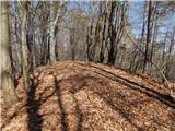
The summit is a 540 m high hill located on the Debeli hrib ridge, a ridge situated between the Ljubljana Marshes and the Horjulščice River valley...
1 h 10 min |
 | Naraplje - Kerješetov vrh
Kerješetov vrh is a 590-metre-high hill located above Jelovice. The hill is covered with forest, and the view is second to none....
1 h 30 min |
 | Brzika - Joški vrh
Joški vrh is a 595-metre-high peak located on the northern side of Donacca Mountain. A short unmarked trail leads to the summit, which branches o...
1 h 15 min |
| Stoperce - Joški vrh
Joški vrh is a 595-metre-high peak located on the northern side of Donacca Mountain. A short unmarked trail leads to the summit, which branches o...
1 h 35 min |
| Prelaz Vrhe - Joški vrh
Joški vrh is a 595-metre-high peak located on the northern side of Donacca Mountain. A short unmarked trail leads to the summit, which branches o...
1 h 5 min |
| Sveti Jurij - Joški vrh
Joški vrh is a 595-metre-high peak located on the northern side of Donacca Mountain. A short unmarked trail leads to the summit, which branches o...
1 h 5 min |
 | Ruše - Globokarjev vrh
...
1 h 15 min |
 | Sora - Breznik (Boben)
Breznik, aka Boben, is a 643-metre-high peak located above the right bank of the Ločnica River, specifically above the Sora, Rakovnik, Goričane a...
1 h 5 min |
 | Izlake (Medijske toplice) - Vrhija (via Podlipovica)
Vrhija is a 648 m high hill located west of Izlake and east of Kolovrat. It lies between Kalanov hrib and Kolovrat ribs, viewed from the N-S dire...
1 h 15 min |
 | Grgar - Vodice (on the route of gas line)
Vodice (according to some records also Sv. Jakob) is a peak located in the western part of the Banjška plateau. The summit, on which the mausoleu...
1 h 30 min |
 | Grgar - Vodice (by road)
Vodice (according to some records also Sv. Jakob) is a peak located in the western part of the Banjška plateau. The summit, on which the mausoleu...
1 h 15 min |
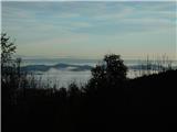
 | Grgar - Sveta Gora (by road)
Sveta Gora is known mainly by the faithful and locals. Sveta Gora is a well-known pilgrimage centre above Nova Gorica. It is visited by believers...
1 h 15 min |
 | Rakovnik - Sveti Florijan (Tehovec) (via Breznik)
The Church of St Florian is a branch church located in the village Tehovec above Medvode. The church, which was first mentioned in 1548, offers a...
1 h 20 min |
 | Vas (sports field) - Sveti Jurij (Remšnik)
The Church of St George is situated on a lookout point in the settlement Remšnik, which is on the slopes of Kozjak. Opposite the church, next to ...
1 h 45 min |
 | Puščava - Lobnikov vrh
Lobnikov vrh is a forested peak above the Drava Valley, situated between Fala and Ruta. From the east, it loks like a solitary rock due to its di...
1 h 20 min |
| Fala Grad - Lobnikov vrh
Lobnikov vrh is a forested peak above the Drava Valley, situated between Fala and Ruta. From the east, it loks like a solitary rock due to its di...
1 h 15 min |
 | Briše - Mali vrh
To the west of Polhov Gradec, between the rivers Mala voda and Velika Božna, is a 708-metre-high hill called Mali vrh. From the grassy summit, wh...
1 h 5 min |
 | Log - Pečke (by road)
Pečke is an easily accessible and recently less and less visited peak located north of the main ridge of Pohorje. It receives more visitors only ...
1 h 5 min |
 | Ravne na Koroškem - Brinjeva gora (above Prevalje)
Brinjeva gora is a popular excursion spot for Prevalj inhabitants, located between the Meža River and the Zelenbreški brok. At the top of the hil...
1 h 10 min |
 | Mala voda - Koreno
Koreno also Koreno is a 729 m high hill located north of Horjul. From the top, where there is a large cross, the Church of St. Mohorj and Fortuna...
1 h 15 min |
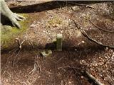
 | Rudnik pri Radomljah - Tolsta gora
Tolsta gora is a 734-metre-high mountain located above Vrhpolje near Kamnik. From the top, where cairn stands, there is no better view, thanks to...
1 h 25 min |
 | Škofja Loka - Vrh soteske (Križna gora)
Vrh soteske is a 735 m high peak located in the south-western part of Križna Gora. There is no better view from the top, which is covered by fore...
1 h 25 min |
| Vešter - Vrh soteske (Križna gora)
Vrh soteske is a 735 m high peak located in the south-western part of Križna Gora. There is no better view from the top, which is covered by fore...
1 h 15 min |
 | Zreče (Terme Zreče) - Golek (steep path)
Golek is a 769-metre-high peak located north-west of Zreče. At the top there is a registration box with a registration book, a stamp and a bench,...
1 h 20 min |
 | Mala voda - Kožljek
Kožljek is a 788 m high peak located to the west of Koreno, specifically above the village of Samotorica. From the top, where there are a few ben...
1 h 15 min |
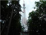
 | Hotavlje - Vrh Slajke
Vrh Slajke is a 790-metre-high hill located above Hotavlje, on the right bank of the Kopačnice River. From the top, where the antenna tower stand...
1 h 15 min |
| Podgora - Vrh Slajke
Vrh Slajke is a 790-metre-high hill located above Hotavlje, on the right bank of the Kopačnice River. From the top, where the antenna tower stand...
1 h 25 min |