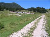
Starting point: Planina Zaprikraj (1208 m)
Time of walking: 7 h 30 min
Difficulty: difficult marked way
Altitude difference: 1036 m
Altitude difference po putu: 1200 m
Map: Julijske Alpe - zahodni del 1:50.000
Recommended equipment (summer): helmet, lamp
Recommended equipment (winter): helmet, ice axe, crampons, lamp
Views: 14.952
 | 2 people like this post |
Access to the starting point:
In Kobarid, leave the main road and head towards Drežnica. Follow the main road through Drežnica to Drežniške Ravni and at the end of this village turn right with your car in the route Pl. Zaprikraj. After a few bends you will come to a flat area where there is a watering trough for cattle and there is also a large parking space. You can park here and walk to Pl. Zaprikraj, which will take you a good hour. I continued my journey by car all the way to Pl. Zaprikraj. In some parts the road is in a pretty bad condition, but if you have a normal car you will slowly get to Pl. Zaprikraj. At the entrance to Pl. Zaprikraj you will come across an iron gate marking the boundary of the pasture. In front of the gate there is a large parking lot and there is also a sign for the Triglav National Park. Park here.
Path description:
Go through the pasture gate and immediately after the gate go right on the mulatiera (the path cut into the hill by the Italian army during WW1) and then zigzag directly uphill. (My friend and I started our hike at the Mountain pasture Zaprikraj pasture, which is 10 minutes from the parking lot) So after an hour and a half of hiking uphill we reached the Vrata saddle, from where the path changed completely. The path goes directly under the top of the ridge and along a narrow path made by the Italian army, once even through a short tunnel. Visible from the photos. If you have a torch, you will be able to see some of the caverns along the way.
At the end of the ridge, the path descends a little and then you come to a path coming from the route of Lake Krnsko. From there, the trail starts climbing again. You can see the summit ahead of you all the time on this climb, but when you get to it you realise that the summit is still about 15 minutes away (go and you will see what I am writing). The trail from Krnsko jezero to the summit of Krno was incredibly crowded with mountaineers, as was the summit and the Gomišček shelter. We reached the summit after a total of 3 hours and 40 minutes (measured from the Pl. Zaprikraj climbing station).
From the summit we went to the Gomišček shelter, which is directly below the summit. Beer and return back to Zaprikraj. It took us exactly 3 hours to get back from the shelter to the mountain hut. As we are among the faster mountaineers, I wrote in the description of this route that you need 7 hours 30 minutes. Don't forget to take water with you, as you won't find it on the trail. Go in the morning, when the steepest part of the trail is still in the shade (no later than 9 am departure from the starting point).
Locals on Pl. Zaprikraj have told me that there are many more World War I remains on the other part of the ridge; from the Vrata saddle to the north.

Pictures:
 1
1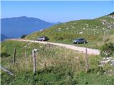 2
2 3
3 4
4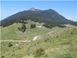 5
5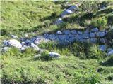 6
6 7
7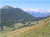 8
8 9
9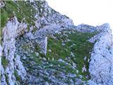 10
10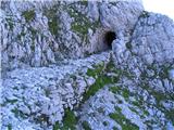 11
11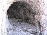 12
12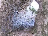 13
13 14
14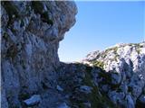 15
15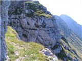 16
16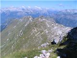 17
17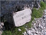 18
18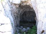 19
19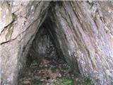 20
20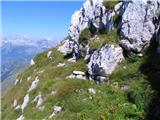 21
21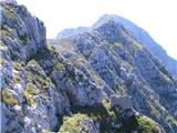 22
22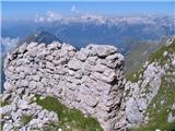 23
23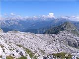 24
24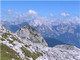 25
25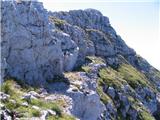 26
26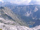 27
27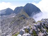 28
28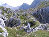 29
29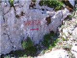 30
30 31
31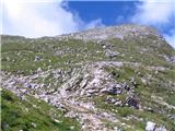 32
32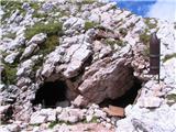 33
33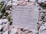 34
34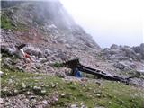 35
35 36
36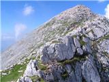 37
37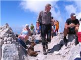 38
38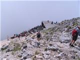 39
39 40
40 41
41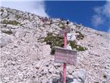 42
42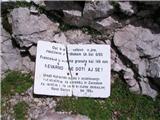 43
43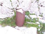 44
44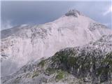 45
45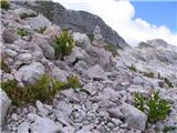 46
46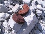 47
47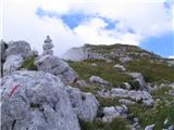 48
48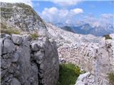 49
49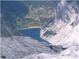 50
50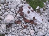 51
51 52
52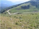 53
53 54
54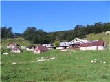 55
55
Discussion about the trail Planina Zaprikraj - Krn
|
| tulipan4. 10. 2011 |
Čas hoje je pretiran. Pravzaprav je začetek poti s planine Zapleč in traja približno štiri ure normalne hoje. Če začnete pot na koncu asfalta pri koritu nad Drežniškimi ravnami pa je hoje pet ur, kar je napisano tudi na smerni tabli.
|
|
|
|
| BT885. 10. 2011 |
Tulipan tale pot vodi tudi čez Krnčico ? Nič napisano  mora bit pa tam blizu.
|
|
|
|
| tulipan20. 10. 2012 |
Od sedla Vrata proti Krnu vodi pot mimo vrha Krnčice. Z grebena Krnčice se je možno povzpeti na vrh Krna tudi po plezalni poti (največ II).
|
|
|
|
| navdušena25. 07. 2014 |
Slišala sem, da so zaradi podorov ob potresu nekatere poti neprehodne. Je kdo bil gori lani ali že letos?
navrhu - izvirni avtor opisa, prosim še za tvoje komentarje: kako je pot označena? Je vstop (začetek poti) označen (smer s puščico??) ali moramo sami poiskati kot pišeš? Koliko je zahtevna pot? Tehnično (plezanje)?
Tulipan - kaj pa je normalna hoja? Koliko časa potrebuješ s parkirišča v Tacnu do vrha Šmarne gore - tvoje normalne hoje? Samo tako, da vidim, kako hitre korake imaš...?! Hvala za odgovore
|
|
|
|
| felix25. 07. 2014 |
Kot je meni znano pot od Krnčice pa do poti, ki poteka od Krnskega jezera na Krn ne spada med označene poti, zato je graja markacistov s strani avtorja opisa neumestna (če se motim me popravite). Lep pozdrav!
|
|
|
|
| tulipan25. 07. 2014 |
Dragi navdušenec, ali kaj si pravzaprav?
V zasebnem sporočilu sem ti lepo napisal, kaj piše na kažipotih.
Glede na namen portala ni treba nikogar pošiljati v Tacen, morda v hribe nad Ljubgojno.
V ZS sem ti sporočil starost in kje bom praznoval. Iskreno vabljen!
|
|
|
|
| winni3. 09. 2020 |
Koliko je zahtevna oziroma izpostavljena ta pot od Krnčice do sedla med Krnom in Batognico?
|
|
|
|
| Bocadillo5. 09. 2020 |
Pot od Krnčice naprej poteka po/ob grebenu do škrbine med Krnom in Srednjim vrhom in je zahtevna in izpostavljena ravno toliko kot od Vrat do vrha Krnčice (nezavarovana muljatera, ponekod deloma izpostavljena -previdnost ni odveč). Na škrbini med Srednjim vrhom in Krnom pot zavije levo in se spusti za vrh Krna. Od tu naprej pa do sedla med Krnom in Batognicami je pot lahka, ni izpostavljena (prečenje kamnitega sveta in melišč).
Srečno, M.
|
|
|