Rudno polje - Triglav (via Kugyjeva polica)
Starting point: Rudno polje (1347 m)
| Lat/Lon: | 46,3458°N 13,9236°E |
| |
Name of path: via Kugyjeva polica
Time of walking: 7 h 30 min
Difficulty: difficult pathless terrain, very difficult marked way
Altitude difference: 1517 m
Altitude difference po putu: 2000 m
Map: Triglav 1 : 25.000
Recommended equipment (summer): helmet, self belay set
Recommended equipment (winter): helmet, self belay set, ice axe, crampons
Views: 41.991
 | 6 people like this post |
Access to the starting point:
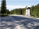
From the motorway Ljubljana - Jesenice take the exit Lesce and follow the road towards Bled. At the traffic lights in Bled, the signs for Pokljuka direct you to the right. Continue through Gorje and past the abandoned ski resort Zatrnik to Rudni Polje on Pokljuka (a large parking lot, a military barracks and a shooting range).
Path description:
From the parking lot continue right up cart track towards mountain pasture Konjščica. Cart track, which climbs steeply at first, soon becomes steep and turns into a footpath a little higher up. A moderate ascent follows, climbing along the Ribnica stream, which has a waterfall in the upper part that can be seen from the path. Further on, the path crosses a small spring and enters the pasture area mountain pasture Konjščica. After a few dozen steps, the path crosses another small spring and ascends gently to the cheese-maker's hut at mountain pasture.
From mountain pasture, continue up the gently sloping meadow slightly to the other side of mountain pasture. There the path becomes dwarf pines and starts to climb, first gently and then steeply. In the last part of the ascent, the path from Rudno Polje joins from the right. There is only a short climb along the torrent to the grassy plain of Jezerce. Here the path turns left and after a few steps leads us into the narrower area of the TNP. Next, we climb along a small spring towards Studorski Preval. A little higher, cross the torrent and the path turns slightly right into the grassy slopes surrounded by dwarf pines. The path then ascends crosswise to Studorski preval, from which a fine view of the Bohinj side opens up.
The path continues, initially descending slightly, then crossing the slopes of Veliki Draški vrh and Tosc with some slight ascents and descents. After a while the path leads us to the grassy southern slope of Tosc. Here, the path to Tosc branches off to the right, and just a few metres further on, the path from Uskovnica joins us from the left. Continue straight ahead, still crossing the slopes of Tosc. The path then crosses a short lane of sparse forest in a slight descent and then leads us to steep slopes. A little further on, the path crosses the precipitous slopes of Tosc on an artificially made wide ledge in a gentle descent. As the path is quite wide it does not cause any problems (caution due to falling rocks, rock fall in 2008). The path then climbs slightly again and leads us to a crossroads where we continue to the right in the direction of Vodnikov's home. There is a further walk of about ten minutes without any major ascents or descents to the Vodnik's home.
From home, continue straight on in the direction Triglav (right up Bohinjska vratca). The path climbs moderately and crosses the slopes below Vernar. Soon we come across the first steel cable, which helps us to overcome a short ledge. The way forward climbs on scree and then leads us to a steep rock jump. A well-protected path leads us up steep steps to the top of this jump. There are a few metres of scrambling up a steep slope before the path leads to the open areas near Konjski preval. This is reached after a short descent.
From Konjski preval continue straight on in the direction of Kredarica (left Planika, right Krma) along the path which, after a few steps, leads us to the next crossroads, where we continue to the left (right Staničev dom). The path continues to climb cross-cuttingly, crossing a large number of small ravines, the crossing of which, however, is not difficult. A little further on, the path crosses some technically difficult places using the fixed safety gear. After this, the path from the Krma valley joins us from the right, and just a few metres further on, we reach the next crossroads, where we continue on the right path in the direction of Kredarica (Planika on the left). Then climb up towards the house at Kredarica, which is already clearly visible ahead. After half an hour's walk from the crossroads for Planika, we reach the house at Kredarica, where we have a view of the peaks on the north side of the Vrata valley.
From Kredarica we continue in the direction of Triglav. A few metres after the signposts, where the Čez Prag trail branches off to the right, leave the marked trail and turn right and continue northwards along the potholes (towards the summit of Glava 2426m). Here there are a number of markers on the rocks indicating potholes. As you approach the summit of Glava, you will see a track on the left leading up through the scree. This path is marked with red lines and soon leads to the more difficult part of the route over the Kugy shelf.
The path over the ledge is then relatively short and not too technically demanding. However, you need to be very careful as the path is narrow, there is a lot of rubble and you are walking directly over the precipitous north face. There are also some ropes to help us in places where the risk of slipping is the highest.
From the Kugy shelf we then reach the Western Triglav plateau, where we can already see the Head in Zaplanja. Here our route turns slightly to the left and soon joins the Plemenice and then the Dolič trail. We start climbing again on the scree and soon enter the climbing part of the trail.
The route continues with a number of fixed safety gear cross-climbs and leads under Triglav notch. Continue up to the notch, where you reach a crossroads. Continue left up (straight down Planika) on a steep but well protected path. The trail then climbs steeply for some time before soon reaching the top of Triglav.

Pictures:
 1
1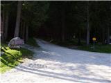 2
2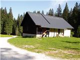 3
3 4
4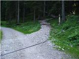 5
5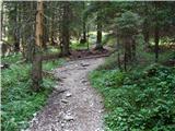 6
6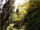 7
7 8
8 9
9 10
10 11
11 12
12 13
13 14
14 15
15 16
16 17
17 18
18 19
19 20
20 21
21 22
22 23
23 24
24 25
25 26
26 27
27 28
28 29
29 30
30 31
31 32
32 33
33 34
34 35
35 36
36 37
37 38
38 39
39 40
40 41
41 42
42 43
43 44
44 45
45 46
46 47
47 48
48 49
49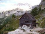 50
50 51
51 52
52 53
53 54
54 55
55 56
56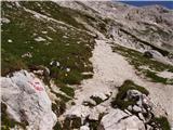 57
57 58
58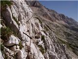 59
59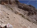 60
60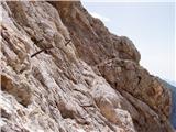 61
61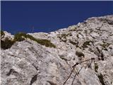 62
62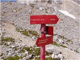 63
63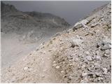 64
64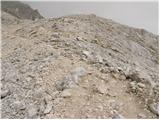 65
65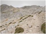 66
66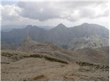 67
67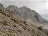 68
68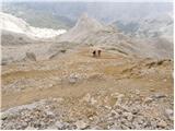 69
69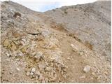 70
70 71
71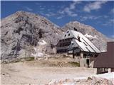 72
72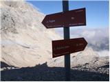 73
73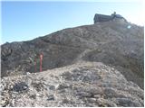 74
74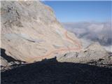 75
75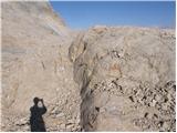 76
76 77
77 78
78 79
79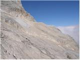 80
80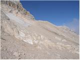 81
81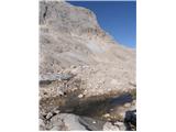 82
82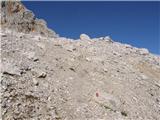 83
83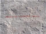 84
84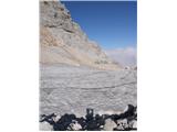 85
85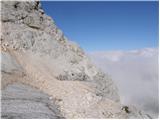 86
86 87
87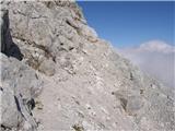 88
88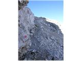 89
89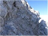 90
90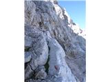 91
91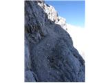 92
92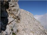 93
93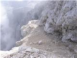 94
94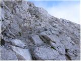 95
95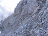 96
96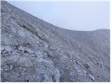 97
97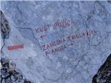 98
98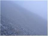 99
99 100
100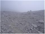 101
101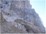 102
102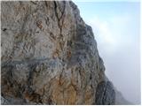 103
103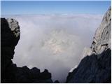 104
104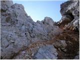 105
105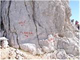 106
106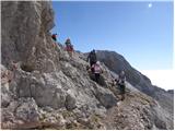 107
107 108
108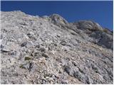 109
109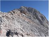 110
110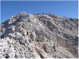 111
111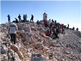 112
112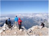 113
113
Discussion about the trail Rudno polje - Triglav (via Kugyjeva polica)
|
| davorin21. 09. 2008 |
rok, hvala. to pot obiščem prvič ko bom imal priložnost. lep pozdrav od hrvaškega zaljubljenca v visoke slovenske gore.
|
|
|
|
| PUHI3. 06. 2009 |
Po tej polici sem šel pred leti v obratni smeri-navzdol. Čeprav je bil avgust je bilo na njej še nekaj snega in obilo grušča, skratka neprijeten občutek nad Steno brez varovanja, letos jo ponovim v nasprotno smer. Mislim pa, da bi bilo treba markacije, ki so delo nekega navdušenca  odstraniti, ali pa pot zavarovati in pravilno označiti, dokler ne pride do nesreče. Pot ni na kartah, najbrž prav zaradi neopremljenosti. Ne predstavljam si neizkušenega gornika, ki bo šel po tej poti ker bo pač videl markacije.
|
|
|
|
| steyr28. 07. 2013 |
Morda kdo ve kakšne so razmere na poti čez Kugyjevo polico...snega še mora bit kar nekaj...morda Igor Zlodej ti kaj veš?? lp
|
|
|
|
| steyr8. 08. 2013 |
Še vedno ma zanima Kugyjeva polica..jo je že letos kdo obiskal ozm. prehodil?lp
|
|
|
|
| IgorZlodej8. 08. 2013 |
Seveda smo šli tudi letos že večkrat čez. Snega na polici trenutno ni več, ga je pa še nekaj na ledeniku, ampak, če greš nekoliko nižje ne bi smelo biti težav. Sicer pa previdno, ker je na poti kar nekaj šodra,pa Lojzetova jeklenica se je tudi snela s klinom vred.
|
|
|