end of road on Pokljuka - Triglav (via Kredarica)
Starting point: end of road on Pokljuka (1340 m)
| Lat/Lon: | 46,3386°N 13,9045°E |
| |
Name of path: via Kredarica
Time of walking: 6 h 10 min
Difficulty: very difficult marked way
Altitude difference: 1524 m
Altitude difference po putu: 1650 m
Map: Triglav 1:25.000
Recommended equipment (summer): helmet, self belay set
Recommended equipment (winter): helmet, self belay set, ice axe, crampons
Views: 85.805
 | 7 people like this post |
Access to the starting point:
a) Leave the Gorenjska motorway at the exit for Lesce, then follow the signs for Bled and Pokljuka. Continue through Gorje and past the Zatrnik ski resort to Rudni Polje on Pokljuka, where there is a large pay parking lot, and a military barracks and shooting range nearby. From here, continue straight along the macadam road, which leads us a little further to a crossroads, where we continue to the right (Uskovnica on the left). Follow this road to the former parking lot Za Ribnico, which is at the end of the road (there are mountain signs for mountain pasture Konjščico).
After the new parking at the end of the road is forbidden, so we park already at Rudne polje, which lengthens the route by about 40 minutes, but it is more convenient to choose the marked trail, which starts already at Rudne polje.
b) From Železniki or Podbrdo, take the road to Bohinjska Bistrica and then continue in the direction of Bled. Shortly after the Petrol station, which is located just after Bohinjska Bistrica, turn left in the direction of Pokljuka and Jereka. The road climbs steeply at first, then gradually flattens out behind Koriti, leading to a junction by the bus station, where you continue right in the direction of Pokljuka, Koprivnik and Jereka (straight ahead Srednja vas). Just after the crossroads we arrive at Jereka, and from the crossroads in front of the church we continue straight on towards Pokljuka (left Podjelje). After Jereka the road starts to climb steeply again, and higher up it levels off and continues along the Mrzle potok. When you join the road from Bled, go left and drive to Rudno Polje, where there is a large pay parking lot, and also a military barracks and shooting range nearby. From here, continue straight along the macadam road, which leads us a little further to a crossroads, where we continue to the right (Uskovnica on the left). Follow this road to the former parking lot Za Ribnico, which is at the end of the road (there are mountain signs for mountain pasture Konjščico).
After the new parking at the end of the road is forbidden, so we park already at Rudne polje, which lengthens the route by about 40 minutes, but it is more convenient to choose the marked trail, which starts already at Rudne polje.
Path description:
From the former parking lot, continue right up cart track towards mountain pasture Konjščica. Cart track, which climbs steeply at first, soon becomes steep and turns into a footpath a little higher up. A moderate ascent follows, following the path which climbs along the Ribnica stream, which has a waterfall in its upper part, which can be seen from the path. Further on, the path crosses a small spring and passes into the mountain pasture Konjščica grazing area. After a few dozen steps, the path crosses another small spring and ascends gently to the cheese-maker's hut at mountain pasture.
From mountain pasture, continue up the gently sloping meadow slightly to the other side of mountain pasture. There the path becomes dwarf pines and starts to climb, first gently and then steeply. In the last part of the ascent, the path from Rudno Polje joins from the right. There is only a short climb along the torrent to the grassy plain of Jezerce. Here the path turns left and after a few steps leads us into the narrower area of the TNP. Next, we climb along a small spring towards Studorski Preval. A little higher, cross the torrent and the path turns slightly right into the grassy slopes surrounded by dwarf pines. The path then ascends crosswise to Studorski preval, from which a fine view of the Bohinj side opens up.
The path continues, initially descending slightly, then crossing the slopes of Veliki Draški vrh and Tosc with some slight ascents and descents. After a while the path leads us to the grassy southern slope of Tosc. Here, the path to Tosc branches off to the right, and just a few metres further on, the path from Uskovnica joins us from the left. Continue straight ahead, still crossing the slopes of Tosc. The path then crosses a short lane of sparse forest in a slight descent and then leads us to steep slopes. A little further on, the path crosses the precipitous slopes of Tosc on an artificially made wide ledge in a gentle descent. As the path is quite wide it does not cause any problems (caution due to falling rocks, rock fall in 2008). The path then climbs slightly again and leads us to a crossroads where we continue to the right in the direction of Vodnikov's home. There is a further walk of about ten minutes without any major ascents or descents to the Vodnik's home.
From home, continue straight on in the direction Triglav (right up Bohinjska vratca). The path climbs moderately and crosses the slopes below Vernar. Soon we come across the first jeklenico, which helps us to overcome a short ledge. The way forward climbs on scree and then leads us to a steep rock jump. A well-protected path leads us up steep steps to the top of this jump. There are a few metres of scrambling up a steep slope before the path leads to the open areas near Konjski preval. This is reached after a short descent.
From Konjski preval continue straight on in the direction of Kredarica (left Planika, right Krma) along the path which, after a few steps, leads us to the next crossroads, where we continue to the left (right Staničev dom). The path continues to climb cross-cuttingly, crossing a large number of small ravines, the crossing of which, however, is not difficult. A little further on, the path crosses some technically difficult places using the fixed safety gear. After this, the path from the Krma valley joins us from the right, and just a few metres further on, we reach the next crossroads, where we continue on the right path in the direction of Kredarica (Planika on the left). Then climb up towards the house at Kredarica, which is already clearly visible ahead. After half an hour's walk from the crossroads for Planika, we reach the house at Kredarica, where we have a view of the peaks on the north side of the Vrata valley.
At the house, head towards the glacier in the direction of Triglava. The trail descends gently at first and then ascends to the start of the climbing part of the trail. A well protected route with the help of wedges and some ropes leads us to the ridge where we join the route from Planica. Next, we almost imperceptibly cross the top of the Mali Triglav. The path along the ridge is scenic and in places very precipitous, but it is very well protected. The ridge path climbs moderately for the most part, but the last climb is steeper. A few metres below the summit, the path to Stanič's shelter branches off to the left, and we continue along the ridge to the summit, where we can see Aljaž's Tower, which we reach in a few steps.
Starting point - Konjščica 30 minutes, Konjščica - Studorski preval 1:30, Studorski preval - Vodnikov dom 1:00, Vodnikov dom - Kredarica 2:00, Kredarica - Triglav 1:10.

Pictures:
 1
1 2
2 3
3 4
4 5
5 6
6 7
7 8
8 9
9 10
10 11
11 12
12 13
13 14
14 15
15 16
16 17
17 18
18 19
19 20
20 21
21 22
22 23
23 24
24 25
25 26
26 27
27 28
28 29
29 30
30 31
31 32
32 33
33 34
34 35
35 36
36 37
37 38
38 39
39 40
40 41
41 42
42 43
43 44
44 45
45 46
46 47
47 48
48 49
49 50
50 51
51 52
52 53
53 54
54 55
55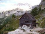 56
56 57
57 58
58 59
59 60
60 61
61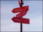 62
62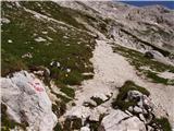 63
63 64
64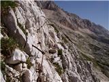 65
65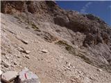 66
66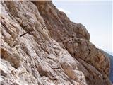 67
67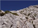 68
68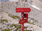 69
69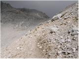 70
70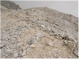 71
71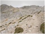 72
72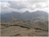 73
73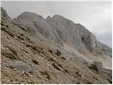 74
74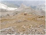 75
75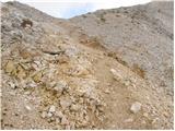 76
76 77
77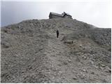 78
78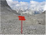 79
79 80
80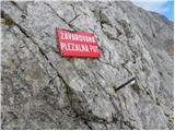 81
81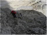 82
82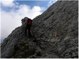 83
83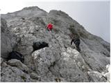 84
84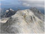 85
85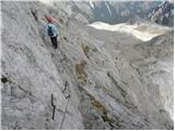 86
86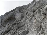 87
87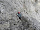 88
88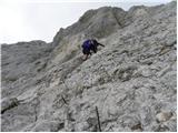 89
89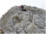 90
90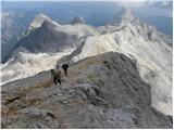 91
91 92
92 93
93 94
94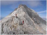 95
95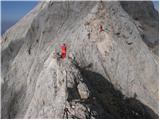 96
96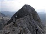 97
97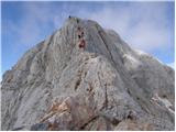 98
98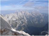 99
99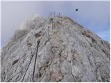 100
100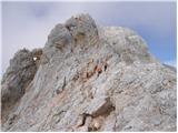 101
101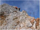 102
102 103
103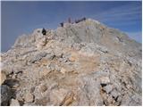 104
104 105
105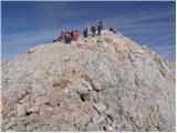 106
106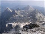 107
107 108
108
Discussion about the trail end of road on Pokljuka - Triglav (via Kredarica)
|
| kmelans15. 08. 2014 |
Živjo!
Midva z možem se 13.9.2014 z Lidlovo odpravo odpravljava prvič in se že full veseliva.
Pogled na objavljene fotografije pa je enostavno fantastičen in že komaj čakam, da se odpravimo tja gor.
Kuštravček
|
|
|
|
| primmy9219. 07. 2015 |
19.7. se je na poti s Kredarice proti Pokljuki izgubila verižica (matrikula) z imenom T. Dolinšek. Če je imel kdo slučajno toliko sreče, da jo je našel, naj me prosim kontaktira na 040148298. Hvala!
|
|
|
|
| mihab1013. 07. 2020 |
Pozdravljeni mi lahko kdo prosim pove če je še možno z avtom do parkirišča na koncu ceste na Pokljuki hvala grem v sredo na pot.
lp
|
|
|
|
| enknap23. 08. 2020 |
22.08.2020 sem nekje na poti (najverjetneje od Vodnika dol) izgubil sončna očala. Če jih je kdo našel naj me prosim kontaktira 030 696 002. Hvala.
|
|
|
|
| t_extreme18. 08. 2021 08:59:58 |
Pozdravljeni, Zanima me, če je kdo zadnje čase hodil po tej poti iz Pokljuke - koliko si zaračunajo parkirni prostor ? Mi gremo za dva dni, in mi je podatek precej pomemben, sploh če je 24h parkiranje možno. Hvala za vsak odgovor  .
|
|
|