Dragomer (bajer) - Strmec (above Dragomer) (mimo Ferjanke)
Starting point: Dragomer (bajer) (309 m)
| Lat/Lon: | 46,0201°N 14,3703°E |
| |
Name of path: mimo Ferjanke
Time of walking: 30 min
Difficulty: easy unmarked way
Altitude difference: 137 m
Altitude difference po putu: 137 m
Map: Ljubljana - okolica 1:50.000
Recommended equipment (summer):
Recommended equipment (winter):
Views: 369
 | 1 person likes this post |
Access to the starting point:
a) From the motorway Ljubljana - Koper, take the exit Brezovica, then continue along the parallel old road towards Vrhnika. After about 5 km of driving, from the town, when you have entered the old road, turn right onto the local road, which continues between meadows and fields. After a few 100 m you reach a hamlet of a few houses, where you turn left at a crossroads and the road turns right just a few metres further. Continue mostly straight ahead, then turn left at a junction with rubbish containers. There is a short, barely noticeable descent and the road leads to the next junction. Here you continue straight ahead, where you are also guided by the signs. There is still a good 100 m to drive, and then park in a suitable place near the next junction.
b) From the motorway Koper - Ljubljana, take the exit Vrhnika, then continue along the parallel old road towards Ljubljana. After 8. 5 km from where you left the old road, turn left onto the local road, which continues between meadows and fields. After a few 100 m you reach a hamlet of a few houses, where you turn left at a crossroads and the road turns right a few metres further on. Continue mostly straight ahead, then turn left at a junction with rubbish containers. There is a short, barely noticeable descent and the road leads to the next junction. Here you continue straight ahead, where you are also guided by the signs. There is still a good 100 m to drive, and then park in a suitable place near the next junction.
Path description:
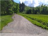
From the starting point, continue along the road to the left, which quickly leads into the forest, where it turns into cart track. Here is a junction of five tracks, continue right on the marked footpath or take the first right cart track. (If you continue straight on or slightly left you will also arrive at Strmec, but there are many crossroads. )
The two variants soon merge. Continue right and immediately the signs direct you slightly left on a marked footpath which climbs slightly steeper. Just a little higher up, we join the first cart track, which quickly leads to the Ferjanka homestead.
Here, continue left past the homestead and the registration box onto a path that goes into the forest. Soon you will reach a less visible crossroads, where you continue to the right and then immediately to the left. The path climbs steeply to the next crossroads, where you go right and after a few 10 metres reach the vegetated top of Strmec.
Pictures:
 1
1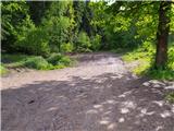 2
2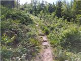 3
3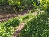 4
4 5
5 6
6 7
7 8
8 9
9 10
10 11
11 12
12 13
13 14
14 15
15 16
16 17
17 18
18
Discussion about the trail Dragomer (bajer) - Strmec (above Dragomer) (mimo Ferjanke)