 | Cerkno - Porezen (via Labinjske lehe)
Porezen is a 1630 m high mountain located between Davča and Baška Grapa. From the top, where a large NOB monument stands, we have a beautiful vie...
4 h 10 min |
 | Gradišče - Vojkova koča na Nanosu (via Sveti Miklavž)
Vojkova koča is located on the southern edge of the Nanoše plateau, close to Pleše, a peak that is clearly visible from the motorway. From the hu...
3 h 45 min |
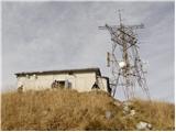
 | Zreče (church of St. Egidij) - Rogla (via Gorenje)
Rogla is the peak in the middle of the ski resort of the same name. The summit is woded with a small clearing on which stands a lookout tower. Th...
3 h 50 min |
 | Oplotnica - Rogla
Rogla is the peak in the middle of the ski resort of the same name. The summit is woded with a small clearing on which stands a lookout tower. Th...
4 h 20 min |
 | Lavamünd - Huhnerkogel/Košenjak
Huhnerkogel lies north of Dravograd and the River Drava on the border with neighbouring Austria. Huhnerkogel is accessible on foot or by car from...
4 h |
 | Bistriški jarek (Glasbeni dom) - Huhnerkogel/Košenjak (via Bivak Piramida)
Huhnerkogel lies north of Dravograd and the River Drava on the border with neighbouring Austria. Huhnerkogel is accessible on foot or by car from...
4 h 45 min |
| Bistriški jarek (Glasbeni dom) - Huhnerkogel/Košenjak (via Sveti Urban)
Huhnerkogel lies north of Dravograd and the River Drava on the border with neighbouring Austria. Huhnerkogel is accessible on foot or by car from...
4 h 30 min |
| Muta (Zgornja Muta) - Huhnerkogel/Košenjak (past Bivouac Piramida)
Huhnerkogel lies north of Dravograd and the River Drava on the border with neighbouring Austria. Huhnerkogel is accessible on foot or by car from...
5 h 45 min |
| Muta (Zgornja Muta) - Huhnerkogel/Košenjak (past Sveti Urban)
Huhnerkogel lies north of Dravograd and the River Drava on the border with neighbouring Austria. Huhnerkogel is accessible on foot or by car from...
5 h 30 min |
 | Svino - Monte Mataiur/Matajur
Monte Mataiur is a scenic mountain located on the border between Slovenia and Itali. From the top, you have a beautiful view of the Kobarid or Br...
3 h 45 min |
 | Svino - Monte Mataiur/Matajur (slovenska smer)
Monte Mataiur is a scenic mountain located on the border between Slovenia and Itali. From the top, you have a beautiful view of the Kobarid or Br...
4 h |
 | Potoki - Stol (Julian Alps)
Stol (1673 m) is located in the longest ridge in the Julian Alps. The ridge is 25 km long, or 35 km if you include the western part. From the top...
4 h |
| Kobarid - Stol (Julian Alps)
Stol (1673 m) is located in the longest ridge in the Julian Alps. The ridge is 25 km long, or 35 km if you include the western part. From the top...
4 h 15 min |
 | Fram - Žigartov vrh
At 1346m, Žigartov vrh is the highest peak in the eastern part of Pohorje. An "observation" tower used to stand on the summit, but was erected on...
4 h 30 min |
| Log - Žigartov vrh
At 1346m, Žigartov vrh is the highest peak in the eastern part of Pohorje. An "observation" tower used to stand on the summit, but was erected on...
3 h 35 min |
| Zgornja Bistrica (Center Vintgar) - Žigartov vrh (through Bistriški vintgar and past Ruška koča)
At 1346m, Žigartov vrh is the highest peak in the eastern part of Pohorje. An "observation" tower used to stand on the summit, but was erected on...
5 h 15 min |
| Pivola (Reka) - Žigartov vrh (via Petkovo sedlo)
At 1346m, Žigartov vrh is the highest peak in the eastern part of Pohorje. An "observation" tower used to stand on the summit, but was erected on...
3 h 55 min |
| Spodnje Radvanje - Žigartov vrh (via Ledinekov kogel)
At 1346m, Žigartov vrh is the highest peak in the eastern part of Pohorje. An "observation" tower used to stand on the summit, but was erected on...
4 h 15 min |
| Spodnje Radvanje - Žigartov vrh (southern path)
At 1346m, Žigartov vrh is the highest peak in the eastern part of Pohorje. An "observation" tower used to stand on the summit, but was erected on...
4 h 35 min |
 | Slivnica pri Mariboru - Žigartov vrh
At 1346m, Žigartov vrh is the highest peak in the eastern part of Pohorje. An "observation" tower used to stand on the summit, but was erected on...
4 h 40 min |
| Zgornja Polskava - Žigartov vrh (through Polskavski vintgar)
At 1346m, Žigartov vrh is the highest peak in the eastern part of Pohorje. An "observation" tower used to stand on the summit, but was erected on...
5 h 30 min |
 | Ruše - Klopni vrh (northern path)
Klopni vrh encloses the lower lying extensive plateau in the eastern Pohorje Mountains from the north-west. The area of the horizontal section at...
3 h 40 min |
| Ruše - Klopni vrh (eastern path)
Klopni vrh encloses the lower lying extensive plateau in the eastern Pohorje Mountains from the north-west. The area of the horizontal section at...
3 h 55 min |
 | Reka - Kojca
Kojca is a scenic peak rising south of Baška Grape. The hay pile on the top offers a beautiful view of the Lower Bohinj Mountains, the Škofjelošk...
3 h 55 min |
 | Lozice - Suhi vrh (Nanos) (gentle path)
At 1313m, Suhi vrh is the highest peak of the karst plateau of Nanos. From the summit, which has a registration box and a stamp (the stamp is cur...
4 h 25 min |
 | Lozice - Suhi vrh (Nanos) (steep path)
At 1313m, Suhi vrh is the highest peak of the karst plateau of Nanos. From the summit, which has a registration box and a stamp (the stamp is cur...
4 h 10 min |
 | Muta (Zgornja Muta) - Kozji vrh (at Košenjak)
Kozji vrh is a 1383-metre-high peak located above Pernice, and its height makes it the highest peak in the municipality of Muta....
3 h 45 min |
 | Zgornja Bistrica (Center Vintgar) - Veliki vrh (on Pohorje) (via Veliko Tinje)
Veliki vrh is a 1344-metre-high peak located above the RTC Jakec - Trije kralji ski resort. The highest point of the peak is located in the fores...
3 h 50 min |
| Zgornja Bistrica (Center Vintgar) - Veliki vrh (on Pohorje) (via Bistriški vintgar)
Veliki vrh is a 1344-metre-high peak located above the RTC Jakec - Trije kralji ski resort. The highest point of the peak is located in the fores...
3 h 45 min |