 | Planina Jezerca - Veliki Zvoh (on unmarked path via Razor)
Veliki Zvoh is the highest point of the Krvavec ski resort. The cable car does not quite reach the top, but it is only a few metres short of the ...
2 h 15 min |
 | Zavetišče na planini Šija - Veliki vrh (Košuta) (Kačja pot)
Veliki vrh, with a height of 2088 m, is the westernmost two-thousander in the longest Slovenian ridge - the Košuta. From the summit, where there ...
2 h |
 | End of road on Pokljuka - Viševnik (via Gola Ravan)
Viševnik is a 2050 m high mountain rising north-west of Rudno polje on Pokljuka. From the top of the peak where the stamp is located, you have a ...
2 h 15 min |
| Rudno polje - Viševnik (via Gola Ravan)
Viševnik is a 2050 m high mountain rising north-west of Rudno polje on Pokljuka. From the top of the peak where the stamp is located, you have a ...
2 h 15 min |
 | End of road on Pokljuka - Viševnik (via source of Zlata voda)
Viševnik is a 2050 m high mountain rising north-west of Rudno polje on Pokljuka. From the top of the peak where the stamp is located, you have a ...
2 h 20 min |
| Rudno polje - Viševnik (via source of Zlata voda)
Viševnik is a 2050 m high mountain rising north-west of Rudno polje on Pokljuka. From the top of the peak where the stamp is located, you have a ...
2 h 20 min |
| Uskovnica (Razpotje) - Viševnik (via source of Zlata voda)
Viševnik is a 2050 m high mountain rising north-west of Rudno polje on Pokljuka. From the top of the peak where the stamp is located, you have a ...
2 h 55 min |
| Uskovnica (Razpotje) - Viševnik (via Gola Ravan)
Viševnik is a 2050 m high mountain rising north-west of Rudno polje on Pokljuka. From the top of the peak where the stamp is located, you have a ...
2 h 50 min |
 | Rudno polje - Mrežce (via Zgornji Razor)
Mrežce is a prominent peak near Lipanski vrh which can be seen on the other side of the ravine between the two peaks. As the slopes towards Poklj...
2 h |
 | Križovec - Barentaler Kotschna/Struška (footpath)
Barentaler Kotschna is a small mountain range located between Stolo or Belščica and Golica. From Veliki vrh, as the highest peak of the mountain ...
2 h 30 min |
| Križovec - Barentaler Kotschna/Struška (by road)
Barentaler Kotschna is a small mountain range located between Stolo or Belščica and Golica. From Veliki vrh, as the highest peak of the mountain ...
2 h 15 min |
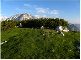
 | Planina Blato - Ogradi
Ogradi are located between mountain pasture Laz and mountain pasture Krstnica. The summit is grassy with plenty of space. A small cross stands on...
2 h 45 min |
 | Rudno polje - Debeli vrh above Lipanca (via Zgornji Razor)
Debeli vrh is a 1962 m high mountain located in a ridge of mountains rising steeply above the Krma valley. From the top, where a stamp is attache...
2 h 15 min |
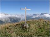
 | Urbas - Weinasch/Vajnež
Weinasch is the highest peak of Belščice, a mountain range located to the west of the better known Stoľa. From the top, where the cross and the S...
2 h 25 min |
| Olipova planina - Weinasch/Vajnež (via Hrašenska planina)
Weinasch is the highest peak of Belščice, a mountain range located to the west of the better known Stoľa. From the top, where the cross and the S...
2 h 50 min |
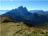
 | Planina Ravne - Veliki vrh (Veža) (via Dleskovec)
Velika vrh is a 2110 m high mountain located in the central part of the Dleskovška plateau. From the top of the peak, where there are two registr...
2 h 45 min |
 | Urbas - Potoški Stol
Potoški Stol is located between Hochstuhl and Weinasch on the border with Austria. Just a few metres below the grassy peak, a cross is erected. T...
2 h 15 min |
| Olipova planina - Potoški Stol
Potoški Stol is located between Hochstuhl and Weinasch on the border with Austria. Just a few metres below the grassy peak, a cross is erected. T...
2 h 40 min |
 | Planina Ravne - Velika Zelenica (via Dleskovec)
Velika Zelenica is the highest peak of the Dleskovská Plateau and the view is accordingly. The most beautiful is the nearby Ojstrica, below which...
2 h 45 min |
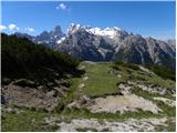
 | Pecol - Cima di Terrarossa
Cima di Terrarossa is a scenic peak located between Jôf di Montasio and Viš. From the summit, which is often full of ibex, you can admire the hig...
2 h 45 min |
 | Koprivna (Kumer) - Velika glava (Peca) (via Knipsovo sedlo)
Velika glava is a peak in the Peć mountain range, located between Petzen and Končnik's Peak. The summit, which borders Austria, offers a beautifu...
3 h 10 min |
 | Rifugio Castiglioni Marmolada - Belvedere
Belvedere is a 2650 m high peak located to the north of Dolomites's highest peak, Marmolada. From the top, where a small cross stands, you have a...
1 h 45 min |
 | Carbonin - Knollkopf / Col Rotondo dei Canope
The 2204-metre-high mountain is located in the Fanes Sennes Prags Nature Park. The mountain is mostly covered with dwarf pines and has a cross at...
3 h |
 | Parking below Malga Giau - Corvo Alto
Corvo Alto or Monte Mondeval is a lesser-known peak in the Italian Dolomites, 2455 metres high, with no marked trail. The grassy summit, on which...
1 h 50 min |