 | Rimske Toplice - Dom v Gorah (via Ogeški potok)
The mountain lodge in Gora is located east of Hrastnik, just a few metres below the 786m-high peak on which the Church of St George stands. From ...
2 h 40 min |
| Rimske Toplice (Šmarjeta) - Dom v Gorah (via Lurd)
The mountain lodge in Gora is located east of Hrastnik, just a few metres below the 786m-high peak on which the Church of St George stands. From ...
2 h 40 min |
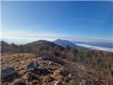
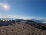
 | Zidani Most - Veliko Kozje
Veliko Kozje is a peak located west of Zidanega Most. From the summit, which has a registration box, there is a beautiful view of Zasavska and Po...
2 h 30 min |
 | Laško - Gozdnik
Gozdnik is a hill rising steeply above the village of Zabukovica. There is no view from the top, due to the forest, but there is a bivouac on it,...
3 h 45 min |
 | Laško - Malič
Malič is a 936 m high peak located between Celje and Laško, above Spodnja Rečica. There is no better view from the top, where the transmitter, be...
2 h 15 min |
 | Štore - Tolsti vrh above Celjska koča (via Žlajfa)
Tolsti, according to some records also Tovsto vrh, is located above the Celjska koča ski resort. The summit, which has a registration box and a s...
2 h 15 min |
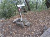
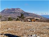
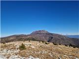
 | Radeče - Nebeška gora
Nebeška gora is the highest peak of the municipality of Radeče on the Sava River. There is a registration book and a stamp on the top, as well as...
2 h 45 min |
| Zidani Most - Nebeška gora (eastern path)
Nebeška gora is the highest peak of the municipality of Radeče on the Sava River. There is a registration book and a stamp on the top, as well as...
2 h 40 min |
| Zidani Most - Nebeška gora (western path)
Nebeška gora is the highest peak of the municipality of Radeče on the Sava River. There is a registration book and a stamp on the top, as well as...
2 h 45 min |
 | Laško (cemetery Laško) - Govško brdo
Govško brdo is an 811m high hill located west of the village of Huda jama above Laško. From the top of the hill, where the registration box and s...
2 h 35 min |
 | Zidani Most - Sveta Marija (Ključevica)
The Church of St Mary is located on a hill called Ključevica, which rises 1067 metres above sea level. From the top, which is partly covered with...
2 h 30 min |
| Radeče - Sveta Marija (Ključevica)
The Church of St Mary is located on a hill called Ključevica, which rises 1067 metres above sea level. From the top, which is partly covered with...
3 h 10 min |
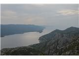 | Bilopolje - Sveti Ilija (Pelješac)
Sv. Ilija, also known as Zmija's Bumblebee, is a 961-metre-high mountain and the highest peak on the Pelješac peninsula. From the top, you can en...
2 h 20 min |
 | Railway station (Most na Soči) - Veliki vrh (above Lom)
Veliki vrh is located in the NE part of the Banjška plateau, rising above the Čepovan valley, the valley of the Soča River and the valley of the ...
3 h 15 min |
 | Rimske Toplice - Vrhe (at Gore) (via Ogeški potok)
...
2 h 50 min |
| Rimske Toplice (Šmarjeta) - Vrhe (at Gore) (via Lurd)
...
2 h 50 min |
 | Pásztó - Muzsla (path marked with green plus)
...
3 h 15 min |
 | Mošćenice - Kremenjak (mimo Kalvarije)
...
2 h 45 min |
| Mošćenice - Kremenjak (po markirani poti)
...
2 h 40 min |
 | Mošćenice - Planinsko zavetišče Kremenjak (mimo Kalvarije)
...
2 h 45 min |
| Mošćenice - Planinsko zavetišče Kremenjak (po markirani poti)
...
2 h 40 min |
 | Mošćenice - Brgud (mimo Kalvarije in Kremenjaka)
...
3 h 15 min |
| Mošćenice - Brgud (po markirani poti in mimo Kremenjaka)
...
3 h 10 min |
 | Mošćenice - Balin (mimo Kalvarije in čez Brgud)
...
3 h 45 min |
| Mošćenice - Balin (po markirani poti in čez Brgud)
...
3 h 40 min |