Similar trips - Raxalm-Berggasthof (Rax) - Jakobskogel (Rax)
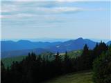
 | Vrh Bače - Kobla
The summit is located in the Lower Bohinj Mountains between Črna prst and Soriška planina. Directly below it is a railway tunnel connecting Bohin...
45 min |
 | Črni Kal - Koprivnik (lower path)
Koprivnik is a 1393-meter-high mountain located between Blegoš and Mladi vrh. From the summit, which has a registration box and a stamp, the view...
1 h |
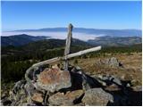
 | Erjavčeva koča na Vršiču - Sovna glava (on old road)
Sovna Glava is a 1750-meter-high grassy peak situated between Prisank and the Vršič Pass. From the summit, there is a nice view of the peaks risi...
50 min |
 | Erjavčeva koča na Vršiču - Sovna glava (on footpath)
Sovna Glava is a 1750-meter-high grassy peak situated between Prisank and the Vršič Pass. From the summit, there is a nice view of the peaks risi...
45 min |
 | Turnovka - Veliki Travnik (Turnovka)
Veliki Travnik, also known as Turnovka by the locals, is located on the western edge of the Smrekovec mountain range. From the summit, which has ...
1 h |
 | Grmovškov dom pod Veliko Kopo - Črni vrh
Črni vrh is the highest peak of Pohorje. Because it is partly unvegetated, it offers a nice view toward Velika Kopa, Uršlja gora, and in the back...
1 h |
 | Koglereck - Huhnerkogel/Košenjak
Košenjak is located north of Dravograd and the Drava River on the border with neighbouring Austria. Access to Košenjak is possible on foot or by ...
1 h |
 | Golte (Alpine garden) - Boskovec (via Hleviška planina)
Boskovec is with 1587 m the highest peak of the Golte plateau. From the top on which a lookout tower stands, a view opens up on part of Kamnik Sa...
1 h 5 min |
| Golte (Alpine garden) - Boskovec (Severjeva pot)
Boskovec is with 1587 m the highest peak of the Golte plateau. From the top on which a lookout tower stands, a view opens up on part of Kamnik Sa...
1 h |
 | Weinebene - Weberkogel
Weberkogel is a less prominent peak located north to northwest of the alpine pass Weinebene. On the 1805-meter-high summit stands a medium-sized ...
1 h |
 | Teichalm (Parking Heulantsch) - Heulantsch
Heulantsch is a 1,473 m high grassy hill above Teichalm, which together with "Sommeralm" forms the largest area of mountain meadows in the Alps.F...
45 min |
 | Feistritzsattel - Harterkogel
Harterkogel is a 1523-meter-high peak situated in the ridge connecting the Pfaffensattel and Feistritzsattel saddles. On the panoramic top, there...
50 min |