 | Ljubljana (Botanični vrt) - Črni hrib (Golovec)
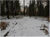
Črni hrib is a 440 m high hill located in the central part of Golovec. The so-called Path of Remembrance and Comradeship leads over the top, wher...
55 min |
 | Ljubljana (Štepanja vas) - Črni hrib (Golovec)
Črni hrib is a 440 m high hill located in the central part of Golovec. The so-called Path of Remembrance and Comradeship leads over the top, wher...
50 min |
 | Ljubljana (Botanični vrt) - Mazovnik (Golovec)
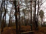
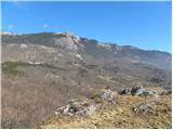
At 450 m, Mazovnik is the highest peak of Golovec, a hill located in the south-eastern part of Ljubljana. Golovec was unforested until the end of...
1 h 5 min |
 | Ljubljana (Štepanja vas) - Mazovnik (Golovec)
At 450 m, Mazovnik is the highest peak of Golovec, a hill located in the south-eastern part of Ljubljana. Golovec was unforested until the end of...
1 h |
 | Volče - Mengore
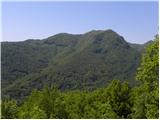
Mengore (453 m) rise between Most na Soči, Volče and Tolmin. From the top, where the Church of St. Mary and the St. Joseph's Shelter stand, you c...
40 min |
 | Stoperce - Škrbatnica
...
50 min |
 | Zlogonje - Vidikovac Vukovoj
...
45 min |
 | Ruše - Kluže
...
45 min |
 | Sveti Mihovil (nad Komižo) - Mali Hum
...
50 min |
 | Gojače - Školj Svetega Pavla above Vrtovin (via water tower)
The St Paul's Collegium is located on a lookout above the village of Vrtovin, west of Ajdovščina. From the church, near which the registration bo...
1 h |
 | Donja Višnjica - Kukelj (direktna strma pot)
...
45 min |
 | Liboje - Kamčič (via organic farm Kralj - northern approach)
Kamčič is a vegetated peak in Posavsko hribovje, located north of Šmohor, between Kotečnik on the left and Veliki Slomnik on the right. It can be...
45 min |
 | Dragomer - Vrh (Debeli hrib)
The summit is a 540 m high hill located on the Debeli hrib ridge, a ridge situated between the Ljubljana Marshes and the Horjulščice River valley...
40 min |
 | Brezovica pri Ljubljani - Vrh (Debeli hrib)
The summit is a 540 m high hill located on the Debeli hrib ridge, a ridge situated between the Ljubljana Marshes and the Horjulščice River valley...
1 h |
 | Vrzdenec - Gradišče above Žažar (via Žažar)
Gradišče nad Žažarjem is a viewpoint with a large wooden cross. From the top, which also has a registration box with a stamp, you have a beautifu...
1 h |
| Vrzdenec - Gradišče above Žažar (via Plesa)
Gradišče nad Žažarjem is a viewpoint with a large wooden cross. From the top, which also has a registration box with a stamp, you have a beautifu...
45 min |
 | Želimlje - Castle Stari grad above Želimlje
Castle Stari grad above Želimlje is a forested peak located between Želimlje and Rogatec above Želimlje....
50 min |
 | Bad Gleichenberg (Eichgraben Weg) - Bschaidkogel (via Mühlsteinbruch)
...
50 min |
 | Povodje - Veliki vrh (Rašica)
Veliki vrh is a 568 m high hill located to the west of Stanet Kosec Vrch. Just a few metres below the summit, which is covered with forest, is a ...
45 min |
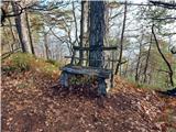 | Celje (hanging bridge) - Hom above Celje
Hom is a forested peak located north of Košnica near Celje. There is a small bench on top of the summit next to the registration box....
1 h |
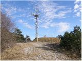 | Sežana - Zidovnik (Sedovnik) (by road)
Zidovnik is a 575m high peak located west of Sežana. The view from the summit, where some transmitters are located, is limited due to the forest ...
1 h |
 | Ruše - Lorbekov vrh
Lorbekov vrh is a 578-metre-high peak located south-west of Ruše. The peak is located in a forest, but the meadow just below the peak offers a be...
45 min |
 | Strmica - Toško Čelo (via Brezarjevo brezno)
Toško Čelo is a 590 m high hill above the village of the same name. From the top, or slightly lower down, you have a beautiful view of part of Lj...
45 min |
 | Šujica (Na Gmajni) - Toško Čelo (along the stream Ostrožnik)
Toško Čelo is a 590 m high hill above the village of the same name. From the top, or slightly lower down, you have a beautiful view of part of Lj...
55 min |
 | Šujica (Na Gmajni) - Toško Čelo
Toško Čelo is a 590 m high hill above the village of the same name. From the top, or slightly lower down, you have a beautiful view of part of Lj...
50 min |
 | Zgornje Poljčane - Baba (at Boč)
...
35 min |
| Zgornje Poljčane - Baba (at Boč) (Detičkova pot)
...
40 min |
 | Sveti Jurij - Joški vrh
Joški vrh is a 595-metre-high peak located on the northern side of Donacca Mountain. A short unmarked trail leads to the summit, which branches o...
1 h 5 min |
 | Dobrova - Vrhe above Dobrova
Vrhe is a lesser-known but important peak in the extreme SE part of the Polhograje hills. It is reached by several unmarked tracks and trails lea...
50 min |
 | Hruševo - Vrhe above Dobrova
Vrhe is a lesser-known but important peak in the extreme SE part of the Polhograje hills. It is reached by several unmarked tracks and trails lea...
1 h |
 | Ožbalt (dam on stream Črmenica) - Turška peč (on cart track)
...
1 h |
 | Podlipoglav - Pugled (past the guard post)
Pugled is a 615m high peak located between Podlipoglav and Veliki Lipoglav. The view from the top of the large NOB monument is limited due to the...
50 min |
 | Podlipoglav - Pugled (on the western ridge)
Pugled is a 615m high peak located between Podlipoglav and Veliki Lipoglav. The view from the top of the large NOB monument is limited due to the...
50 min |