 | Škrbina - Mali Golak
Mali Golak is the highest of the Golaki. It did not get its name because it is supposed to be the smallest, but because it had the smallest mount...
2 h |
 | Ribniška koča - Lovrenška jezera
The Lovrenška jezera are located on a high bog in the middle of Pohorje between Rogla and Ribniško Pohorje. The smaller lakes, which receive wate...
2 h 5 min |
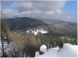
 | Grmovškov dom pod Veliko Kopo - Mali Črni vrh
Mali Črni vrh is located above the Ribniška koča mountain hut. At the top, there is an artificial lake intended for snowmaking. From the top, the...
1 h 35 min |
 | Turški klanec - Mrzovec
Mržovec is the most prominent peak in the heart of the Trnovo Plateau. Its location offers wonderful views, though high trees obscure them from t...
1 h 30 min |
 | Atelsko sedlo - Boskovec
Boskovec is with 1587 m the highest peak of the Golte plateau. From the top on which a lookout tower stands, a view opens up on part of Kamnik Sa...
1 h 30 min |
 | Zgornji Goreljek - Javorov vrh (Pokljuka)
Javorov vrh is a 1,482 m high mountain amidst the vast forests of Pokljuka, specifically between the Konjska dolina and Jelje mountain pastures. ...
1 h 30 min |
 | Soriška peč - Žbajnek
Žbajnek is a 1,538 m high peak located west of Ratitovec. From its grassy summit, surrounded by sparse forest, beautiful views open up of the Jul...
1 h 30 min |
 | Bohinjsko sedlo - Kačji rob (Ovharn)
Kačji rob (Ovharn) is a 1,552 m high peak situated between the Zgornji Jirn mountain pasture and the lesser-known Žbanjek peak. From the summit, ...
2 h |
| Soriška peč - Kačji rob (Ovharn)
Kačji rob (Ovharn) is a 1,552 m high peak situated between the Zgornji Jirn mountain pasture and the lesser-known Žbanjek peak. From the summit, ...
2 h 30 min |
 | Weinebene Straße - Weberkogel
Weberkogel is a less prominent peak located north to northwest of the alpine pass Weinebene. On the 1805-meter-high summit stands a medium-sized ...
1 h 30 min |
 | Koča na Klopnem vrhu - Pesek
Pesek is a 1,423-meter-high peak on Pohorje, located above Koča na Pesku....
2 h 23 min |
 | Teichalm (Teichalmsee) - Rote Wand (upper path)
Rote Wand is a 1,505-meter-high mountain in the Graz Mountains in Styria, Austria. The name "Rote Wand" (red wall) comes from its southeast-facin...
2 h 15 min |
 | parking below Weinebene - Steinmandl (Golica / Koralpe) (via Grünangerhütte)
Steinmandl is a panoramic peak in the Golica/Koralpe range, where numerous stone cairns have been built....
1 h 40 min |
 | Feistritzsattel - Grabmayr-Kogel
Grabmayr-Kogel is a lesser-known peak located southeast of the Pfaffensattel pass. From the partly vegetated summit, views open up toward the sum...
1 h 40 min |
 | Knödelhütte - Hirschegger Alm (southern peak)
The southern peak in the Hirschegger Alm ridge is located west of the settlement of Hirschegg. From the summit, where a cross stands, a beautiful...
1 h 35 min |
| Unterauerlinger Hütte - Hirschegger Alm (southern peak)
The southern peak in the Hirschegger Alm ridge is located west of the settlement of Hirschegg. From the summit, where a cross stands, a beautiful...
1 h 25 min |
 | Sommeralm - Osser
Osser is a 1548-meter-high peak situated above the Teichalm plateau. From the summit, where a cross stands, a beautiful view opens up over the su...
2 h |
| Teichalm (Harrerhütte) - Osser
Osser is a 1548-meter-high peak situated above the Teichalm plateau. From the summit, where a cross stands, a beautiful view opens up over the su...
1 h 35 min |
 | Weinebene - Barofen
Barofen is a panoramic peak between the Weinebene Pass and the mountain road to Hebalm. On its 1,720 m high summit stands a cross with a summit r...
2 h |
 | Weinebene Straße - Barofen
Barofen is a panoramic peak between the Weinebene Pass and the mountain road to Hebalm. On its 1,720 m high summit stands a cross with a summit r...
1 h 40 min |
| Gasthof Pfeifferstocker - Barofen
Barofen is a panoramic peak between the Weinebene Pass and the mountain road to Hebalm. On its 1,720 m high summit stands a cross with a summit r...
2 h |
 | Weinebene Straße - Renneiskogel
Renneiskogel is a lesser-known pathless peak in the Lavanttal Alps, north of the Weinebene Pass....
1 h 25 min |
| Gasthof Pfeifferstocker - Renneiskogel
Renneiskogel is a lesser-known pathless peak in the Lavanttal Alps, north of the Weinebene Pass....
1 h 45 min |
 | Schanzsattel - Stanglalpe
Stanglalpe is a peak in the Fischabacher Alpen mountain group, which lies in the hills east of the Mur. The peak itself is situated beside a road...
2 h 20 min |
 | Nassfeld - Javornik / Auernig
Javornik (Italian Monte Auernig, German Auernig) is a 1864-meter-high peak above Mokrine on the border between Austria and Italy. The summit, cov...
1 h 30 min |
| Nassfeld - Javornik / Auernig (via Auernig Alm)
Javornik (Italian Monte Auernig, German Auernig) is a 1864-meter-high peak above Mokrine on the border between Austria and Italy. The summit, cov...
1 h 35 min |
 | Nassfeld - Kronalpe / Monte Corona
Koren (Italian Monte Corona, German Kronalpe) is a 1,832-meter-high peak east of the Mokrine Pass, more precisely above the Vrh Krnice saddle on ...
1 h 35 min |
 | Raxalm-Berggasthof (Rax) - Preiner Wand (Rax)
Preiner Wand is a panoramic peak in the Rax mountain group, where a large cross stands....
1 h 40 min |
 | Kugina kuća - Laktin vrh
Laktin vrh is a panoramic grassy peak in Central Velebit, east of the main ridge. It is a checkpoint for HPO and the Velebit Circuit. From the su...
1 h 30 min |