 | Gabrje - Tošč
Tošč, which became the highest peak of the Polhov Gradec Hills decades ago when the Yugoslav army lowered Pasja ravan by 9 metres, is located nor...
3 h 5 min |
 | Podgorje ob Sevnični (Kurja vas) - Lisca
Lisca is a panoramic peak located north of Sevnica. From the summit, where a meteorological radar station stands, there are fine views of Posavsk...
3 h 40 min |
 | Jamce - Sinji vrh (eastern path via Škraplje)
Sinji vrh is a panoramic mountain between Col, Ajdovščina, and Predmeja. It offers views across much of western Slovenia (the sea on clear days)....
2 h 55 min |
 | Prebold - Reška planina (via Tolsti vrh and Strnik)
Reška planina is a peak in the Posavsko hribovje, located southwest of Prebold. The summit is in the forest and marked by a sign on a tree; it li...
3 h |
 | Teharje - Tolsti vrh above Celjska koča (via Srebotnik on CPP)
Tolsti vrh (also recorded as Tovsti vrh in some sources) is situated above the Celjska koča ski area. The summit has a logbook box and stamp, but...
3 h |
 | Kozje - Veliki Javornik (Bohor) (via Koprivnik)
Veliki Javornik, at 1023 meters, is the highest peak of Bohor. Although the summit is unvegetated and there are no higher hills nearby, there is ...
2 h 45 min |
 | Lesično - Koprivnik (Bohor)
Koprivnik, or Veliki Koprivnik, is one of numerous peaks on Bohor. It is located between Koča na Bohorju and Veliki Javornik. From the summit, wh...
3 h 15 min |
 | Kozje - Koprivnik (Bohor) (via Vetrnik)
Koprivnik, or Veliki Koprivnik, is one of numerous peaks on Bohor. It is located between Koča na Bohorju and Veliki Javornik. From the summit, wh...
3 h 10 min |
 | Podgorje ob Sevnični (Kurja vas) - Koprivnik (Bohor)
Koprivnik, or Veliki Koprivnik, is one of numerous peaks on Bohor. It is located between Koča na Bohorju and Veliki Javornik. From the summit, wh...
3 h 15 min |
 | Cerkno - Ermanovec (via Kladje)
Ermanovec is a 1,026-meter-high peak situated between Cerkno and Gorenja vas, more precisely above Sovodenj and Trebija. Just a few steps from th...
2 h 55 min |
| Cerkno - Ermanovec (via Planina pri Cerknem)
Ermanovec is a 1,026-meter-high peak situated between Cerkno and Gorenja vas, more precisely above Sovodenj and Trebija. Just a few steps from th...
3 h |
 | Cerkno - Štor (via Planina pri Cerknem)
Štor is a 1005 m high peak located directly above the Koča na Ermanovcu hut. The summit itself is forested, but from a meadow just a few dozen me...
2 h 45 min |
 | Matrafüred - Kékestető (red path via Peresberc in Negyeshatar)
Mátra is a hill range located 70 km east of Budapest. It hosts Hungary's two highest peaks: Kékes/Kekes at 1,014 m, the highest point in Hungary,...
2 h 45 min |
 | Puščava - Hlebov vrh (Rdeči Breg)
Rdeči breg stretches between the Radoljna gorge to the east, the Drava to the north, and the Velka stream to the east. It is separated from the m...
2 h 55 min |
| HE Ožbalt - Hlebov vrh (Rdeči Breg)
Rdeči breg stretches between the Radoljna gorge to the east, the Drava to the north, and the Velka stream to the east. It is separated from the m...
2 h 50 min |
 | Nakovana - Sveti Ilija (Pelješac)
Sveti Ilija, also Zmijino brdo, is a 961-meter-high mountain and the highest peak of the Pelješac Peninsula. From the top, a nice view opens up o...
2 h 45 min |
 | Radlje ob Dravi - Bricnik (via Zavetišče Onuk - Glavar)
Bricnik is a 1,017-meter-high peak located in the Kozjak hills above Muta. On the forested summit there is a logbox with logbook and stamp (the K...
2 h 55 min |
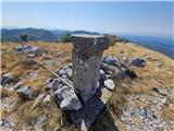
 | Radlje ob Dravi - Sveti Pankracij (Radelca) (via Župank and Sveti Urban)
The Church of St. Pankracij on Radelca lies on the border ridge between Slovenia and Austria; since 1966, following an interstate agreement, it h...
4 h |
| Brezno - Sveti Pankracij (Radelca) (by Remšniški potok)
The Church of St. Pankracij on Radelca lies on the border ridge between Slovenia and Austria; since 1966, following an interstate agreement, it h...
2 h 50 min |
 | Vuhred - Janževski vrh
Janževski Vrh is a 915-meter-high mountain situated above the right bank of the Drava River and the left bank of the Velka Stream. At the summit ...
4 h |
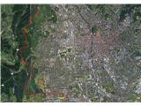 | Graz Center West - Fürstenstand (Plabutsch) (via Buchkogel)
Fürstenstand is the highest summit of Plabutsch hill at 754 m. It lies west of Graz and rises about 400 m high.A lookout tower stands on the summ...
4 h |
 | Ožbalt - Sršenov vrh
Sršenov vrh is a 963-meter-high peak located in the Kozjak hills, more precisely between Ožbalt and Zgornja Kapla. The summit itself offers no sp...
2 h 45 min |
 | Rimske Toplice - Vrhe (at Gore) (via Ogeški potok)
Vrhe is a forested 781-meter-high peak located northwest of the Planinski dom hut in Gore....
2 h 50 min |
| Rimske Toplice (Šmarjeta) - Vrhe (at Gore) (via Lurd)
Vrhe is a forested 781-meter-high peak located northwest of the Planinski dom hut in Gore....
2 h 50 min |
 | Podgorje ob Sevnični (Kurja vas) - Ješivec
Ješivec (also Ješivc) is a 934-meter-high peak in Posavsko hribovje, from which a beautiful view opens up mainly to the south and west, while for...
2 h 45 min |
 | Majkovi - Neprobić
Neprobić is a panoramic peak above Slano, near the border with Bosnia and Herzegovina. The summit has a geodetic marker and is an HPO point. From...
3 h |