 | Ceršak - Gradišče Novine
Gradišče Novine is the second control point of the Šentilj Trail. It is located between Šentilj and the Mura River....
1 h 30 min |
 | Rucmanci - Gomila
Gomila is a 352-meter-high peak in the Slovenske gorice, located between Ptuj and Ljutomer. From the summit, which features an 18-meter-high obse...
1 h |
 | Ženavlje (memorial plaque) - Church of the Holy Trinity (Gornji Petrovci)
The Church of the Holy Trinity is located on a scenic hill in the settlement of Gornji Petrovci. From the top, there is a beautiful view of Gorič...
1 h 20 min |
 | Selo (log cabin TIC Selo) - Sveti Benedikt (Kančevci)
The Church of St. Benedict is located on a 358-meter-high hill at the end of the village of Kančevci. Next to the church are the House of Spiritu...
1 h 30 min |
 | Kuzma - Zalka
Zalka is a 362-meter-high peak in Goričko, located northeast of Kuzma. The summit lies in the forest, but some views are still available....
52 min |
 | Budinci (border crossing) - Katin breg / Katalin-hegy (on marked path)
Katin breg / Katalin-hegy is a small hill located on the Hungarian side of the Čepinci border crossing, near the village of Verica-Ritkarovci / K...
52 min |
 | Lenart v Slovenskih goricah - Zavrh v Slovenskih goricah (via lake Radehova)
Zavrh is a village in the Slovenske gorice, known to hikers primarily as a checkpoint on the extended Slovenian mountain trail. In the center of ...
1 h 20 min |
 | OMP Kuzma - Wolfsriegel
Wolfsriegel is a fairly panoramic peak situated between the settlements of Dobra / Neuhaus am Klausenbach and Liba / Minihof-Libeau in Austria's ...
1 h 15 min |
 | Martinje (sports center Martinje) - Tromejnik / Dreiländerecke / Harmashatar
Tromejnik, known in German as Dreiländerecke or in Hungarian as Hármashatár, is a 390 m high hill located at the tripoint between Slovenia, Austr...
1 h |
 | Gornji Senik / Felsőszölnök - Tromejnik / Dreiländerecke / Harmashatar
Tromejnik, known in German as Dreiländerecke or in Hungarian as Hármashatár, is a 390 m high hill located at the tripoint between Slovenia, Austr...
1 h 30 min |
 | Eisenberg an der Raab - Tromejnik / Dreiländerecke / Harmashatar (by the border)
Tromejnik, known in German as Dreiländerecke or in Hungarian as Hármashatár, is a 390 m high hill located at the tripoint between Slovenia, Austr...
1 h 10 min |
 | Eisenberg an der Raab - Tromejnik / Dreiländerecke / Harmashatar (by road)
Tromejnik, known in German as Dreiländerecke or in Hungarian as Hármashatár, is a 390 m high hill located at the tripoint between Slovenia, Austr...
1 h 20 min |
 | border crossing Kramarovci - Sveta Ana pri Igu / Sankt Anna am Aigen
Sveta Ana pri Igu / Sankt Anna am Aigen is a settlement near the border with Slovenia where a church of St. Anne more than 300 years old stands. ...
1 h |
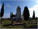 | Komare doline - Sveti Kvirik
The church or chapel of St. Kvirik (also listed on maps and elsewhere as St. Kirk, Kirik, Kvirk, Kvirin, or Kirin) stands on a panoramic rise bet...
1 h 20 min |
 | OMP Kuzma - Sotinski breg (Kugla)
Sotinski breg (Kugla) is the highest peak of Prekmurje at 418 m. From the summit, which features a wooden observation tower with a bell and cross...
1 h |
 | OMP Kuzma - Stadelberg
Stadelberg is a 418 m high peak located near the highest summit of Prekmurje. A residential house stands at the top, but just a short walk below ...
55 min |
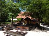 | Phliški bajer - Mengeška koča on Gobavica (lower path)
Gobavica is a hill rising above Mengeš. Mengeška koča mountain hut stands on it, along with a goat pen. It is one of the starting points for the ...
1 h |
 | Ljubljana (Sveti Urh) - Orle
Orle is a settlement in the Municipality of Škofljica, located on a small hill northeast of the Ljubljana Marshes. A few meters below the highest...
1 h 10 min |