Zgornje Poljčane - Sveta Lucija above Studenice (by Studenice castle)
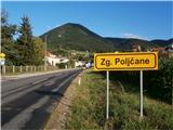
Starting point: Zgornje Poljčane (270 m)
Name of path: by Studenice castle
Time of walking: 1 h 35 min
Difficulty: easy marked way
Altitude difference: 20 m
Altitude difference po putu: 180 m
Map: Posavsko hribovje Boč - Bohor 1:50.000
Recommended equipment (summer):
Recommended equipment (winter):
Views: 1.728
 | 2 people like this post |
Access to the starting point:
a) From the route of Maribor, leave the motorway at Slovenski Bistrica, where signs direct you to Poljčane. Continue through the centre of Poljčane in the direction of Zgornje Poljčane, where you can park in the centre of the village, a suitable place is the parking space next to the cemetery.
b) From the direction of Ljubljana, leave the motorway at Slovenske Konjice and drive through Žič, Loč and Zbelovego to Poljčane. At the crossroads, turn right in the direction of Zgornje Poljčane for a few hundred metres, where you can park in the centre of the village; a suitable place is the parking space next to the cemetery.
Path description:
After a short visit to the centre of Zgornje Poljčane, continue across the Bela stream by the parish church, slightly up the road. On the left side of the path you reach the entrance to the church, with a relief of two Romans on the facade. After the visit, continue left towards Podboč along the asphalt road, also the Formila cycle path. Soon you reach the pleasant, small settlement of Podboč and on the left side of the path the Černogova yew tree and a fountain restored by the locals.
Continue right up the road, now entering the Boč & Plešivec Landscape Park. The asphalt surface turns into a forest road. The view to the left is also a view lower down to the surroundings of Poljčany and the bed of the flooded river Dravinja between fields and meadows. The road turns into a forest and soon reaches a grassy plateau where the road is laid.
On the grassy plain there is a small warehouse with a field on the right and vineyards on the left. Continue through the forest again and the road winds pleasantly to the left, right. . . At the end of the flat part, a sharp left downhill and a narrow forest stone road, while up to the right is the continuation higher up to Boč.
Continue downhill, the path descends pleasantly, is well beaten and soon reaches the first intermediate destination, the source of the Toplega/Studeniškje Stream at 295 metres.
Cross a wooden footbridge and continue to the other side of the stream and soon continue downhill on a short level, where there is a nun's cemetery to the left of the path and a small spring/stream in a wooden trough to the right. A few metres further up a narrower path by a wooden railing for a handhold. Follow the path higher up, down to the old town of Studenice with the monastery complex. Further on, the second intermediate goal Studenica Castle is reached by the descendant of the old Maribor vine. Over the centuries, some of it has been preserved, even restored a decade ago, and the intermediate destination of the trail rewards us with beautiful views of the world of the Dravinja valley, Boč. . .
After a short visit, you will descend a steep/directive path to the centre of Studenice. Passing the premises of the wine-growers' association and the parish church, we reach the entrance to the monastery complex, where we can refresh ourselves with one of the best waters at a small fountain. After a short tour of the central part of Studenice, continue northwards through Studenice along the road by the stream. Continue over the bridge over the Dravinja and immediately turn slightly left and straight ahead between the cultural centre and the transformer. Continue left on a gentle ascent along a grassy path between a house on the left and a kindergarten on the right. At the kindergarten turn right and continue on the asphalt surface slightly more steeply uphill towards the destination, which is visible. Follow the road and you will soon reach the parking area in front of St Lucy's Church, which is surrounded by a cemetery within the walls.
The length of the route described is about 5000 metres, 180 positive vertical metres and 160 negative vertical metres.

Pictures:
 1
1 2
2 3
3 4
4 5
5 6
6 7
7 8
8 9
9 10
10 11
11 12
12 13
13 14
14 15
15 16
16 17
17 18
18 19
19 20
20 21
21 22
22 23
23 24
24 25
25 26
26 27
27 28
28 29
29 30
30 31
31 32
32 33
33 34
34 35
35 36
36 37
37 38
38 39
39 40
40 41
41 42
42 43
43 44
44 45
45 46
46 47
47 48
48 49
49 50
50 51
51 52
52
Discussion about the trail Zgornje Poljčane - Sveta Lucija above Studenice (by Studenice castle)
|
| bruny3. 11. 2014 |
S kolesom gorskim v  kratki večerni aktivnosti... Sv. Lucija in Studeniški grad,03.11.2014. Vozil v nasprotni smeri opisane poti in to med 4,79 in 9,07 kilometrom. Trase sem se natančno držal. V obratni smeri morda nekoliko bolj zahtevna sicer pa itak enostavno. Do Sv. Lucije po učnih poteh ob Dravinji. Vetrovno je bilo, temperatura prijetno večerna, danes brez meglic in jasno je bilo nebo.
|
|
|
|
| bruny6. 11. 2014 |
Danes v večernem času po opisani poti v pohodniškem koraku. V ponedeljek nekaj malega improvizacije, ker je bila zadeva opravljena s kolesom. Odhodil iz izhodišča korektno, natančo po opisu od slike do slike. Tudi povratek popolnoma identičen. Tereni delno razmočeni in blatni...Meglice so se že dokaj konkretno tvorile ob in nad reko Dravinjo še posebno ob povratku. Boč nekje med jasnino in oblačnostjo. Vetra ni bilo. Srečal nikogar bil je le to že večerni čas... Trasa poti: Sv. Lucija nad Studenicami iz Zgornjih Poljčan ob Studeniškem gradu,06.11.2014.Lep pozdrav
|
|
|