Vent - Wildspitze (običajna pot mimo Breslauer Hütte in preko Mitterkarjocha)
Starting point: Vent (1895 m)
| Lat/Lon: | 46,8605°N 10,91494°E |
| |
Name of path: običajna pot mimo Breslauer Hütte in preko Mitterkarjocha
Time of walking: 6 h 30 min
Difficulty: very difficult unmarked way
Altitude difference: 1873 m
Altitude difference po putu: 1873 m
Map: Ötztaler Alpen Wildspitze, 30/6 1:25.000
Recommended equipment (summer): helmet, self belay set, ice axe, crampons
Recommended equipment (winter): helmet, ice axe, crampons
Views: 1.670
 | 2 people like this post |
Access to the starting point:
From Ljubljana, take the motorway past Salzburg towards Munich. At the Dreieck Inntal multi-level junction, take the A93 towards Innsbruck/Kufstein/Brenner. On returning to Austria, follow the A12 motorway past Innsbruck, Telfs and Mötz, then turn off at exit 123 near Ötztal Bahnhof onto the B186/B171/Ötztal/Haiming. The B186 road into the Ötztal valley passes Oetz, Längenfeld and the centre of the valley, Sölden. Just a few kilometres further on from Sölden, at the village of Zwieselstein, you turn onto a fast climbing but comfortable asphalted road towards Vent. In the tourist village of Vent, park in one of the many (paid) car parks; the best place to park is near the lower station of the Wildspitze chairlift. The parking fee in Vent is €5/day in 2020.
Path description:
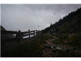
From Vento, follow the route of the Wildspitze chairlift in the route mountain pasture Stablein (hint: in summer, the Stablein restaurant can be reached by chairlift, which shortens access by about an hour). A modestly marked but obvious and wide path leads in large meanders through mountain meadows until it ends at the road by the restaurant at mountain pasture Stablein.
Near the restaurant, take a slightly narrower but fairly gentle path which, in the presence of numerous signs, climbs very gently towards the Breslauer Hütte. A short distance below the hut, cross the Rofenkar glacial stream with the help of a small bridge and follow the path, which climbs a little more steeply, up the last slope to the Breslauer Hütte. From Venta, it is just under three hours' walk to the hut.
At the Breslauer Hütte, follow the signs for Wildspitze, which direct you north-east along the (initially still marked) track, which climbs relatively steeply towards the scree valley between the Wildspitze and Brochkoglov massifs. The trail crosses over a small lake in a gentle ascent and then continues gently along the middle of the glacial valley.
As you cross towards the heart of the valley, which hosts the remains of the once more extensive Mitterkarferner glacier, the markings become fainter, but periodically you will still be guided by individual cairns. After about half an hour of moderate ascent towards the southern wall of the Hinterer Brochkogel, the route, which we now suspect rather than see, turns to the north-east and begins to climb more steadily towards the wall below the Mitterkarjoch Pass. Warning: in the event of fog, it is often difficult to follow the optimum direction in the last part of the ascent up the valley. In this situation, it is a good idea to stay further north (higher) below the walls surrounding the glacial valley.
Climb up the very crumbly terrain towards the rocky barrier below Mitterkarjoch. The last part of the climb up the valley is usually covered in snow all year round; full winter gear is needed to cross the steep snow tongue safely. On the last slope, the individual fixed safety gear markers, which are particularly useful in icy conditions, indicate the right route.
After approaching the buttress below Mitterkarjoch, the most technically demanding part of the tour awaits us: we have to climb an admittedly relatively short traverse that climbs steeply over the face to the pass. The belayed route is the most difficult at the start, when the initial movements are used to overcome a vertical - even slightly overhanging in a short place - grade (difficulty C). After this, the route remains moderately difficult and quite exposed for a while (up to B/C), but becomes easier and easier higher up (up to B, mostly A/B). After about half an hour of climbing on the ferrata, the rocks lead us to a rock ledge, after which we reach the Mitterkarjoch Pass (3470 m), where we can see a vast view across the vast Taschachferner glacier. Here we prepare for the glacier crossing.
From the Mitterkarjoch, continue along the steel cable in a (north)easterly direction. As the climb to Wildspitze is popular at all times of the year, we will probably get reliable tracks, but otherwise we climb (gently at first) north of the cliffs that drop down towards the approach valley. Soon after the summit ridge of the southern head of Wildspitze first comes into view, we turn south-east from a small rocky jetty in the middle of the glacier. Follow the glacier path to the foot of the rocky finishing ridge leading to Wildspitze. Under normal conditions, the ascent of the glacier takes about one hour.
Warning: although the tracks of the predecessors generally avoid (or bypass) the glacial crevasses as best they can, caution is definitely advisable when crossing them; the Taschachferner is a rather dangerous, crevassed glacier.
It takes about 15 minutes to get to the top of the ridge, which is quite crumbly, but for the most part it is quite wide and easy. Just below the summit, there are some more difficult rocks to climb in a slightly precipitous world (I). A large cross and a wide view await us at the top.
Even if it is not technically too difficult, the ascent to Wildspitze is a long, arduous and complex high-altitude tour which is not without its objective dangers (falling rocks in the valley area below the Brochkoglov and Wildspitze walls; steep passages which are glaciated for most of the year; glacial crevasses at the crossing of the Taschachferner). Despite the popularity of the route, orientation is relatively difficult - especially in adverse weather conditions. To cross the Taschachferner Glacier safely, it is necessary to walk in a team and to use a full glacier kit. Although the protected route to the Mitterkarjoch is quite short, it is in places quite challenging and exposed, and above all often icy - not least as it is entirely above 3400 metres - so I recommend self-guiding.
Due to the length and the high altitude difference along the route, I recommend staying overnight in the Breslauer Hütte, but be aware that the hut is often fully booked in the high mountain season.

Pictures:
 1
1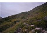 2
2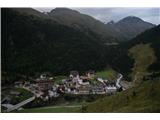 3
3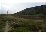 4
4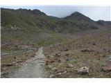 5
5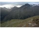 6
6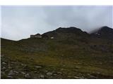 7
7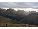 8
8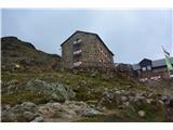 9
9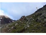 10
10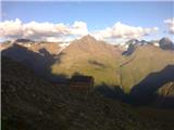 11
11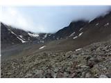 12
12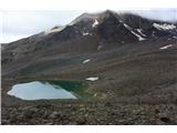 13
13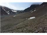 14
14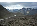 15
15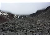 16
16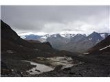 17
17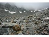 18
18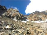 19
19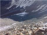 20
20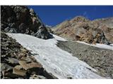 21
21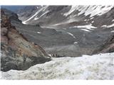 22
22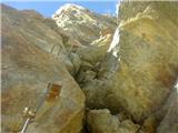 23
23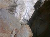 24
24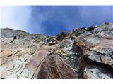 25
25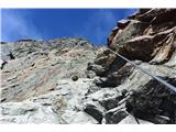 26
26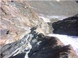 27
27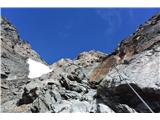 28
28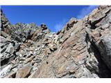 29
29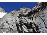 30
30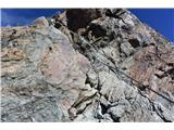 31
31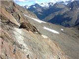 32
32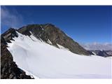 33
33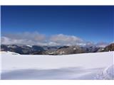 34
34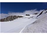 35
35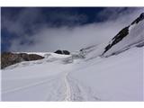 36
36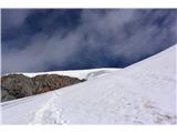 37
37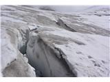 38
38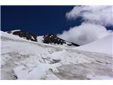 39
39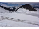 40
40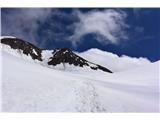 41
41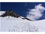 42
42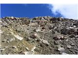 43
43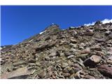 44
44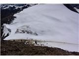 45
45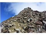 46
46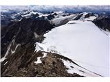 47
47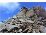 48
48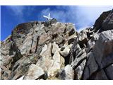 49
49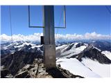 50
50
Discussion about the trail Vent - Wildspitze (običajna pot mimo Breslauer Hütte in preko Mitterkarjocha)