Uskovnica (Razpotje) - Koča na Uskovnici
Starting point: Uskovnica (Razpotje) (1215 m)
| Lat/Lon: | 46,3267°N 13,9107°E |
| |
Time of walking: 20 min
Difficulty: easy marked way
Altitude difference: -61 m
Altitude difference po putu: 5 m
Map: Triglav 1:25.000
Recommended equipment (summer):
Recommended equipment (winter):
Views: 18.686
 | 2 people like this post |
Access to the starting point:
a) Leave the Gorenjska motorway at the exit for Lesce, then follow the signs for Bled and Pokljuka. Continue through Gorje and past the ski resort Zatrnik to Rudni Polje on Pokljuka, where there is a large pay parking lot and a military barracks and shooting range nearby. From here, continue straight along the macadam road, which leads us a little further to a crossroads, where we turn left in the direction of Uskovnica (right mountain pasture Konjščica). From here, drive another 500 m to the former parking lot above Uskovnica. This area is called Razpotje.
Nowadays, parking is forbidden in this parking lot, so you have to park at Rudno Polje, which will take about 35 minutes longer, or choose the starting point at Uskovnica (Lom).
b) From Železniki or Podbrdo, drive to Bohinjska Bistrica and then continue in the direction of Bled. Shortly after the Petrol station, which is located just after Bohinjska Bistrica, turn left in the direction of Pokljuka and Jereka. The road climbs steeply at first, then gradually flattens out behind Koriti, leading to a junction by the bus station, where you continue right in the direction of Pokljuka, Koprivnik and Jereka (straight ahead Srednja vas). Just after the crossroads we arrive at Jereka, and from the crossroads in front of the church we continue straight on towards Pokljuka (left Podjelje). After Jereka the road starts to climb steeply again, and higher up it levels off and continues along the Mrzle potok. When you join the road from Bled, go left and drive to Rudno Polje, where there is a large pay parking lot, and also a military barracks and a shooting range nearby. From here, continue straight on the macadam road, which leads us a little further to a crossroads where we turn left towards Uskovnica (right mountain pasture Konjščica). From here, drive another 500 m to the former parking lot above Uskovnica. This area is called Razpotje.
Nowadays, parking is forbidden in this parking lot, so you have to park at Rudno Polje, which will take about 35 minutes longer, or choose the starting point at Uskovnica (Lom).
Path description:
From the former parking lot at the crossroads, continue along the macadam road closed to public traffic in the direction of Uskovnica. The road immediately starts to descend quite steeply and quickly leads to a bridge over the Ribnica River (the Ribnica is the stream that separates Uskovnica from Pokljuka). After the bridge, the road turns sharp left and then crosses the slopes above the right bank of the Ribnica River in a gentle descent. Some 10 m further on, a road branches off to the right, leading towards mountain pasture Konjščica, and we continue straight on to the next crossroads, which is located in the immediate vicinity of the Chapel of Our Lady Queen of Peace. Here another path continues to the right towards mountain pasture Konjšica, straight ahead on the right side of the chapel towards Vodnikov dom and Triglav, and we continue to the left towards the Cottage on Uskovnica. Continue along the road, which soon crosses a fence, and then near a bumpy meadow, continue left again in the direction of Hut na Uskovnici. From the last crossroads to the hut is only about 50 m walk.

We can extend the trip to the following destinations: Planina Zajamniki,
Planina Konjščica (1 h 5 min),
Planina pod Mišelj vrhom (4 h),
Velo polje (3 h 30 min),
Vodnikov dom na Velem polju (3 h 15 min),
Ablanca,
Jezerski Stog (5 h 15 min),
Viševnik,
Mali Draški vrh (3 h 10 min),
Vernar (4 h 30 min),
Veliki Draški vrh,
Tosc (4 h),
Dom Valentina Staniča pod Triglavom (6 h 15 min),
Dom Planika pod Triglavom (4 h 45 min),
Triglavski dom na Kredarici (5 h 15 min),
Triglav (6 h)
Pictures:
 1
1 2
2 3
3 4
4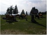 5
5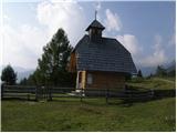 6
6 7
7 8
8 9
9 10
10 11
11 12
12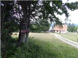 13
13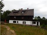 14
14 15
15
Discussion about the trail Uskovnica (Razpotje) - Koča na Uskovnici
|
| prlekj14. 01. 2009 |
Zanima me kaka je pot iz Srednje vasi proti koči na Uskovnici! Z prijatelji namreč načrtujemo spomladi tridnevni pohod čez Triglav! Kake so kaj povezave da se vrnem po avto?
|
|
|
|
| Klin15. 01. 2009 |
Predlagam sledečo pot Srednja vas, Uskovnica, Vodnikov dom, Planika (spanje), Triglav, Dolič, Prehodavci, Triglavska jezera (spanje), Ovčarija, Dedno polje, Blato, Voje, Stara Fužina, Srenja vas.
Pa ne pozabite, da so spomladi poti okrog Triglava še zasnežene.
|
|
|
|
| triglavski15. 01. 2009 |
Pa tudi Planika bo spomladi še zaprta, zato spanje ne bo možno, na Triglavskih jezerih bi se dalo v bivaku prespat.
|
|
|