Trdnjava Kluže - Kota 1313
Starting point: Trdnjava Kluže (532 m)
| Lat/Lon: | 46,3612°N 13,5893°E |
| |
Time of walking: 2 h 20 min
Difficulty: easy marked way
Altitude difference: 781 m
Altitude difference po putu: 781 m
Map: Julijske Alpe - zahodni del 1:50.000
Recommended equipment (summer): helmet, lamp
Recommended equipment (winter): helmet, ice axe, crampons, lamp
Views: 28.978
 | 1 person likes this post |
Access to the starting point:
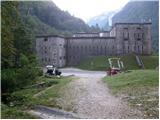
From Bovec, drive towards the Predel border crossing. After a few kilometres, we see the Kluže Fortress and a parking lot along the road.
Path description:
From the parking lot, take the wide path on the opposite side of the road from the Kluže Fortress (towards Rombon). After a few minutes' walk, the path, which climbs only slightly, leads to the old military tunnel. As the tunnel is quite long, a headlamp or other torch will be helpful. After the tunnel, the path leads to a crossroads, where we continue left in the direction of Na Robu, 1313 (slightly to the right Možnica). The path then climbs steeply for a short time and then continues in a slight cross-climb with some views towards the Kluže Fortress. After about 30 minutes of walking, the path leads to the next military fortifications, Fort Hermann.
Continue to the right in the direction Rombon on a path that climbs steeply upwards through the forest. At the crossroads, continue on the marked trail, or keep to the Na Robu and 1313 markers, and higher up only to the 1313 marker. After a good two hours' walk, the trail leads us to a beautiful viewpoint, where we can look out over the nearby Jerebica and the other mountains above the Koritnice valley. The path then goes back into the dense forest and leads us to a crossroads of two paths. Continue left along the less visible path in the direction of mark 1313 (straight Rombon). The way forward is completely laid out, turns slightly to the right and leads us out of the forest, where we then in a few steps come to the corner 1313, from which we open a beautiful view of the Bovec basin.

Pictures:
 1
1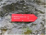 2
2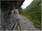 3
3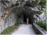 4
4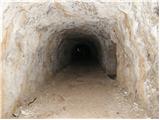 5
5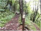 6
6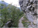 7
7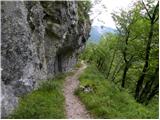 8
8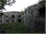 9
9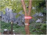 10
10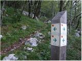 11
11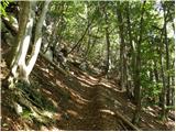 12
12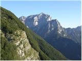 13
13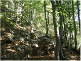 14
14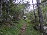 15
15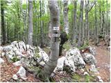 16
16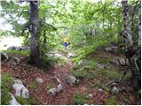 17
17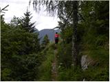 18
18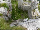 19
19 20
20
Discussion about the trail Trdnjava Kluže - Kota 1313
|
| Iguana15. 04. 2010 |
Vikend bo lep, rada bi se povzpela na koto 1313. Malce me je tale opis zmotil, slika 11, kjer na na obeh straneh smerokaza napisano da gre za koto 1313. Je na vrhu še sneg?
Hvala vsem za odgovore.
|
|
|
|
| divjipetelin15. 04. 2010 |
Poglej odgovor pri izletu trdnjava Kluže-Rombon.
Lep dan
|
|
|
|
| Iguana15. 04. 2010 |
Hvala, sem bila malo v "strahu", da tele poti ne gleda prav veliko pohodnikov in se zato še tam napisala.
|
|
|
|
| Zasavčan28. 03. 2012 |
Zanima me kakšne so kaj zdaj razmere na poti proti Koti 1313 iz Kluž. 
|
|
|
|
| ales5028. 03. 2012 |
vse je v mejah normale,tko,da pot pod noge,so pa table,ki te usmerijo na cilj,nč pretresljivega,samo pazi na granate,hehe,
|
|
|
|
| bojan7925. 09. 2015 |
Za koliko minut/ur je hoje od razpotja Rombon - Kota 131 (slika 16)?
|
|
|
|
| MANGRT25. 09. 2015 |
Od 45 do 80 minut odvisno od tempa.
|
|
|
|
| Schriftsteller19. 06. 2016 |
A je bil kdo pred kratkim na Koti 1313?
Jaz sem danes probal, pa je na cca. 1100m n.v. naenkrat en kup podrtih dreves, potem se izgubi shojena pot in nič več markacij.
Zato sem se na cca. 1300m n.v. obrnil nazaj ...
Šele doli pri Fort Hermann sem se spomnil, da so na Hribi.net objavljene koordinate, iPhone pa ima kompas :-) Pa drugič.
|
|
|
|
| Smetar19. 06. 2016 |
Lani decembra so bila tudi ta drevesa na poti, moreš it malo gor pa proti desni (pod steno) in čez nekaj časa se priključiš poti ali pa greš direktno preko dreves... po približno 100 višincev si na neoznačeni stezi ki te vodi do Kota 1313 (če zaviješ na levo) ali pa proti Rombonu, če greš naravnost...
|
|
|