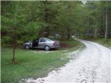
Starting point: The Krma Valley (930 m)
| Lat/Lon: | 46,3851°N 13,9071°E |
| |
Time of walking: 2 h 55 min
Difficulty: difficult marked way
Altitude difference: 1035 m
Altitude difference po putu: 1070 m
Map: TNP 1:50.000
Recommended equipment (summer): helmet
Recommended equipment (winter): helmet, ice axe, crampons
Views: 9.008
 | 1 person likes this post |
Access to the starting point:
Leave the Gorenjska motorway at the Hrušica exit and follow the road towards Kranjska Gora. Just before the village of Dovje, the road branches off to the left and leads to Mojstrana (Vrata, Kot and Krma). Follow the road in the direction of the village of Radovna and the valleys of Krma and Kot. The relatively steep road then takes us past the TNP signboard, after which the road soon lays down and leads us to a crossroads where the macadam road to the valley of Kot branches off to the right. Continue straight ahead on the road, which begins to descend. In the middle of the descent, the road to the Krma valley branches off to the right (straight ahead Radovna). A little further on, you come to the next crossroads, where you continue to the right in the direction of Krma. The macadam road then leads to Kovinarska hut, and we follow it further. Occasionally, a slightly worse road then leads us to the parking lot in front of the gate.
Path description:
Just 50m before the parking lot, a marked trail to Lipanca branches off to the left. Take this path, which after an initial three-minute walk begins to climb steeply. After a few minutes of walking, the path leads us under the cliffs where we notice a sign that the path we are going to climb was built in 1952.
The path then climbs steeply through the forest to a slightly more difficult crossing, where we are helped by wedges, less steep steps and a steel cable (not difficult). The path then leads us between dwarf pines and we continue to follow it to a mighty torrential ravine. The ravine is reached by a slight descent at first, and on the other side by a steep cross-climb up a steep slope. Crossing the ravine is difficult or even impossible after heavi rainfall, but as the slopes are steep the water drains away quickly. The path then climbs through the forest, still steeply upwards. The path, however, gets closer and closer to the steep slopes and rocky cliffs. As the forest becomes much thinner, the path climbs steeper still. For a short time the path becomes so steep that you have to help yourself a little with your hands. This part is a slip hazard in wet conditions, but in dry conditions it is not a major hazard. The path then leads under steep rocky cliffs where, especially in spring, there is a high risk of falling rocks. The crossing under the cliffs is almost horizontal, and then the path climbs again. Again, we are helped by a small (easy) steel cable, which leads to grassy slopes. Next, we cross the slopes again, exposed to falling rocks, and soon afterwards we reach a less steep part of the path. We then climb along an increasingly scenic path mostly between dwarf pines and sparse forest to a crossroads where we turn right in the direction of Mrežce and Lipanski vrh (left Brda and Debela peč). The path then crosses scree under the cliffs of an unnamed peak in a gentle ascent and after a few minutes leads us to a ridge where we are again at a crossroads. Continue right along the ridge, where you will see a marker for Lipanski vrh. The route then climbs mostly between dwarf pines on the increasingly steep summit slope Lipanski vrh, which is reached without major difficulties. From Lipanski vrh continue along the sheltered ridge towards Mrežce. The fixed safety gear trail leads us down the ridge to the notch between Lipanski vrh and Mrežce. There are a few steps of descent, and then fixed safety gear takes you up the easy top slope to the summit.

Pictures:
 1
1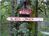 2
2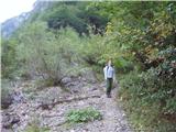 3
3 4
4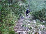 5
5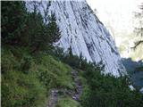 6
6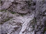 7
7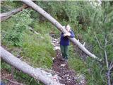 8
8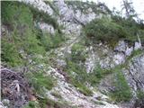 9
9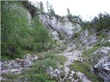 10
10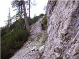 11
11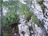 12
12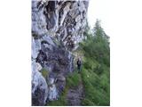 13
13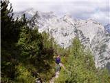 14
14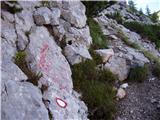 15
15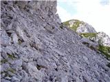 16
16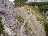 17
17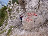 18
18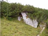 19
19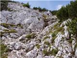 20
20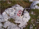 21
21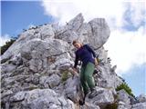 22
22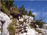 23
23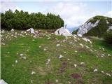 24
24
Discussion about the trail The Krma Valley - Mrežce
|
| LuncaPetra10. 11. 2024 10:58:38 |
Danes sva prehodila to pot. Je lepo prehodna in markirana, razen tik pred prečenjem hudournika, sva namesto da bi zavila levo, šla direktno proti hudourniku in si precej otežila nekaj metrov.
Sestopila sva po isti, in na mestih kjer je blo ivje je bla pazljivost res potrebna, ker poteka vecina skozi gozd, so korenike zelo spolzke.
|
|
|