The Kot Valley - Rušnata Mlinarica
Starting point: The Kot Valley (950 m)
| Lat/Lon: | 46,4157°N 13,8977°E |
| |
Time of walking: 3 h
Difficulty: difficult unmarked way
Altitude difference: 827 m
Altitude difference po putu: 935 m
Map: Triglav 1:25.000
Recommended equipment (summer): helmet
Recommended equipment (winter): helmet, ice axe, crampons
Views: 8.219
 | 2 people like this post |
Access to the starting point:
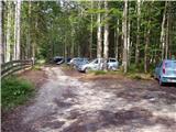
Leave the Gorenjska motorway at the Hrušica exit and follow the road towards Kranjska Gora. Just before the village of Dovje, the road branches off to the left and leads to Mojstrana (Vrata, Kot and Krma). Follow the road in the direction of the village of Radovna and the valleys of Krma and Kot. The relatively steep road then leads us past the TNP signboard, after which the road soon lays down and leads us to a crossroads where a dirt road branches off to the right into the Kot valley (straight ahead to Radovna and Krma). This sometimes slightly worse road is then followed to a parking area, where you will also see mountain signs.
Path description:
From the parking lot, continue along the wide cart track (worse road), which after a few minutes of easy walking leads to a turning point (parking is not recommended here). Here, the marked path towards Stanič's home descends slightly and crosses the torrent, and we continue slightly to the right on the cart track, which climbs gently up the right side of the torrent (left bank). After about 3 minutes' walk from the turning point, the unmarked hunting trail branches off to the right from the cart track, and we continue our climb on this trail. The path, which initially climbs steeply, leads us quickly to a small stream, along which we climb for a short time and then cross it. On the other side of the stream, the path climbs relatively steeply in numerous bends and after a while leads us out of the forest onto a rather overgrown grassy slope. The path from which we have views mainly of Macesnovec, Luknja Furnace and Rjavina is again hidden in the forest higher up. When the path leads us to a nondescript side ridge, we can climb in a few steps to a beautiful viewpoint from which we can see the peaks above the Kot and Krma valleys.
On an inconspicuous ridge, the path turns left (not along the ridge) and leads us in a cross-climb to a small grassy scree field surrounded by numerous larch trees. The path then goes into the forest again, turns right at a higher altitude and after a slightly longer cross-climb leads us to the main ridge, where we continue to the sharp left.
The path continues along a steep and relatively narrow forested ridge (a slip hazard in wet conditions). The not-to-difficult path up to here then leads to the Rušnata Mlinarica summit, where the less experienced can also finish the trip (the summit is recognisable by its large man). The route continues along the ridge, which is increasingly overgrown with dwarf pines, but the passages are beautiful as dwarf pines is burnt. A little further on, the path leads to a short steep jump (at a scraped rock), where you have to climb 5 metres steeply upwards using dwarf pines. The path, which runs along a relatively steep slope and occasionally a narrow ridge, then leads us over numerous overhills and ravines to the unspoilt and scenic summit of Rušnate Mlinarica. Although the trail is not marked, it is not particularly difficult to navigate, but in the fog it is difficult to know which is the right peak. Technical difficulties on the route occasionally exceed the 1st climbing level. Due to the steepness, especially in the upper part, it is a good idea to wear a helmet. There is a high risk of slipping on the ridge in the wet.

Pictures:
 1
1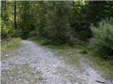 2
2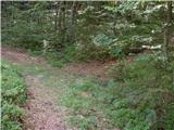 3
3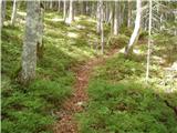 4
4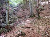 5
5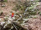 6
6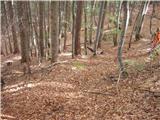 7
7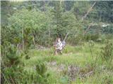 8
8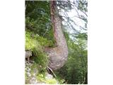 9
9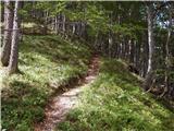 10
10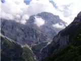 11
11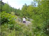 12
12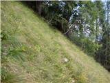 13
13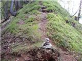 14
14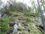 15
15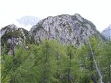 16
16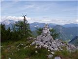 17
17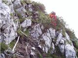 18
18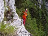 19
19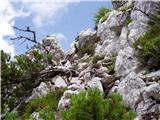 20
20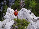 21
21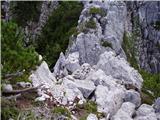 22
22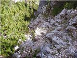 23
23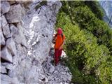 24
24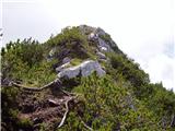 25
25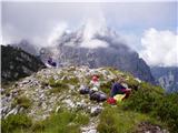 26
26
Discussion about the trail The Kot Valley - Rušnata Mlinarica
|
| Tadej14. 08. 2008 |
Neverjetno miren kraj v objemu dveh obleganih alpskih dolin. Greben med Kotom in Vrati nam nudi lepe razglede na najvišje vrhove Julijskih Alp.
|
|
|
|
| katty25. 06. 2012 |
Ja res, in kaj vidiš-na eni strani Macesnovec, Luknjo peč z Vrbanovimi špicami, pa Begunjski vrh, na čelu mogočen Cmir, nato pa na desni strani Škrlatico, Stenar, Planjo, ter seveda Kukovo špico   . Vredna obiska, a samo z znanjem plezanja I in deloma tudi II stopnje.
|
|
|
|
| tango3. 11. 2020 |
Idealen dan za obisk samotnega grebena nad Kotom in Vrati. Vsakič posebej sem navdušen nad prekrasno speljano potjo , ki v kot narisanih ključih premaguje še kar strma pobočja. Pot suha, tudi težavnejši deli, nazaj grede pa so bili kratki rokavi nujni. Lep in neverjetno topel dan.
|
|
|