Sveti Trije kralji - Mali Šumik waterfall
Starting point: Sveti Trije kralji (1181 m)
| Lat/Lon: | 46,43788°N 15,46004°E |
| |
Time of walking: 2 h 15 min
Difficulty: difficult marked way
Altitude difference: -291 m
Altitude difference po putu: 125 m
Map: Pohorje 1:50.000
Recommended equipment (summer): helmet
Recommended equipment (winter): helmet, ice axe, crampons
Views: 421
 | 1 person likes this post |
Access to the starting point:
Drive to the centre of Slovenska Bistrica, where you turn off at the traffic lights in the direction of the health centre and continue along Partizanska cesta. Then drive through the town, continuing straight on, on the outskirts of the town, and at the industrial zone turn onto the road towards Tinje, Sveti Trem kralji and Black Lake. The asphalt road is slightly narrower and starts to climb, initially leading past the Hunting Hut of the pizzeria Gams, then higher up through the village of Visole, and a few kilometres higher up we arrive at Zgornje Tinje, from where we follow the signs for the ski resort of Jakec - Trije kralji (Three Kingdoms). Park in the parking lot at the foot of the ski slope, or near the Church of St. Three Kings.
Path description:
From the starting point, walk to the Church of St. Three Kings and continue in the direction of the Black Lake and Urška's path, quickly arriving at the nearby ski slope, which you continue along for a short time and then cross (during the ski slope's operation, the ski slope and the ski lift are crossed higher up - above the ski lift and the ski slope). The way forward takes us past the ARSO weather station, and we continue to follow the markings, and after a few minutes on the connecting ski slope we arrive at another ski slope, which we also cross (up Veliki vrh, next to the ski slope). Then we cross the ski lift and another ski slope, and then the trail comes into the forest, where after a few minutes of further walking we arrive at a cross, next to which stands the Urška Trail teaching board. The path continues slowly descending and leads us to a marked crossroads where we continue straight in the direction of the Šumik waterfall and Ruš (on the left, Črno jezero and Osankarica).
Continue along the gently sloping path through the forest, which leads us across the Sand Flat, and behind the nondescript peak of Trije studenci, the path gradually begins to descend. A little lower down, the forest thins out and the path, which gradually stops descending, has several crossroads where you can follow the markings. After a short slight ascent, we start descending again and lower down we reach a macadam road leading from Areh towards Osankarice, but we just cross it and continue descending to the next road, which we follow to the left (right Ruška koča na Arehu), and quickly reach the starting point Bajgot na Šumiku, where one of the paths to Rušy (the Holcarska path through the valley Lobnica) branches off to the right.
Continue in the above-mentioned direction, along which there are also signs for the Mali and Veliki Šumik waterfalls (straight ahead - Šumik estate, Koča na Klopnem vrh. . . ).
The way forward begins to descend gently at Lobnica, but soon we arrive at a warning that the path is very steep and slippery further on. A little further on, cross the footbridge to Lobnica, then descend the right bank of Lobnica, where you gradually move to steeper and steeper slopes. Further on, rungs and ropes help us in the more difficult places, and a little lower down we descend over a short wall using the fixed safety gear. Below the wall, the slope is also quite steep and dangerous for slipping, but the descent is mainly without fixed safety gear.
A little lower still, we reach the place where the stamp is located, and then we follow the protected path down to the viewpoint of the Veliki Šumik waterfall.
From Veliki Šumik, we continue along the trail, which continues to descend along Lobnica on slopes that are steep in places. A little further on, cross the Verna stream with the help of a rope, which turns into several small waterfalls at high water level. Just a little further on, cross the river Lobnica via a small bridge. Just after the bridge, you will see the signs for the waterfall, which is 9 m high.
From the signboard you can see the waterfall from above, but if you want to see it from below, continue along the path, which first ascends and then descends to the crossroads of the path. Here we continue right down the steep path, which quickly leads us to the Lobnica riverbed, from which we have a view of the Mali Šumik waterfall.
St. Three Kings - Veliki Šumik waterfall 2:00, Veliki Šumik waterfall - Mali Šumik waterfall 0:15.

Pictures:
 1
1 2
2 3
3 4
4 5
5 6
6 7
7 8
8 9
9 10
10 11
11 12
12 13
13 14
14 15
15 16
16 17
17 18
18 19
19 20
20 21
21 22
22 23
23 24
24 25
25 26
26 27
27 28
28 29
29 30
30 31
31 32
32 33
33 34
34 35
35 36
36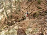 37
37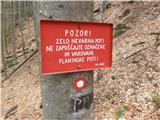 38
38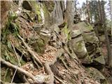 39
39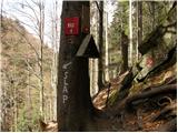 40
40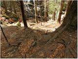 41
41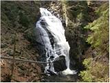 42
42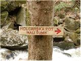 43
43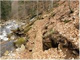 44
44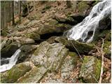 45
45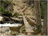 46
46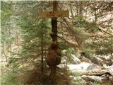 47
47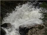 48
48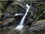 49
49
Discussion about the trail Sveti Trije kralji - Mali Šumik waterfall