Suhadolnik - Bivak pod Grintovcem
Starting point: Suhadolnik (901 m)
| Lat/Lon: | 46,3352°N 14,5102°E |
| |
Time of walking: 3 h 45 min
Difficulty: difficult marked way
Altitude difference: 1199 m
Altitude difference po putu: 1350 m
Map: Kamniške in Savinjske Alpe 1:50.000
Recommended equipment (summer): helmet
Recommended equipment (winter): helmet, ice axe, crampons
Views: 16.605
 | 2 people like this post |
Access to the starting point:
From the motorway Ljubljana - Jesenice take the exit Kranj - East and follow the road towards Jezersko, but only as far as the village of Kokra. In this village, just a few metres before the road crosses the bridge over the Kokra River, you will see a road leading towards Suhadolnik. The road turnoff is located when we are on the right side of the river (left bank) and the road marker is approximately 7 km. Follow this road to the parking area, which is about 300 m in front of the Suhadolnik farm.
Path description:
At the beginning of the parking lot, you will see mountain direction signs directing you to the road, which will take you to a small crossroads near the Suhadole farm in less than 5 minutes' walk. Here we continue on the road to the right, and we follow it for about 5 minutes, or until we reach the place where the signs lead us to the ascending cart track. We then climb cart track for a short distance, and then the signs direct us to the right onto a footpath which climbs moderately through the forest. Higher up, we return to cart track, which leads us a few metres further to a forest road, which we then follow to its end (it takes about half an hour to get here).
At the end of the road, the marked path splits into two parts. Continue along the left-hand path (to the right, the slightly easier "Old Path"), which climbs further along the folded cart track. A little further on, the markings direct us slightly to the right onto torrential layers of sand, and the path continues through the forest on the other side, where it starts to climb steeply. Higher up, we reach a small cave, and the path beyond it becomes technically difficult. With the help of a rope ladder, we climb a step higher, and the path then continues on a steep slope, where occasionally a wedge helps us. Higher up, the path turns to the right, climbs steep and, especially in the wet, slippery slopes and then leads to an excellently protected crossing. With the help of wooden steps or ladders and the aid of a rope ladder, we climb up the steep slope, which would be very dangerous without the aforementioned fixed safety gear. Higher up, we are helped by a few more pegs, and the route then lays down and crosses a short exposed slope, where we are helped by an emergency fence. Just a little further on, we come to the next ladder, which does not have a belay, but the crossing is not particularly difficult. There is a short descent into a small gully, which is crossed after this. On the other side of the gully we climb steeply (a few staples help us), and then the path slowly lays down and in a few 10 steps of further walking leads us to a place where it joins the slightly easier "Old Path".
There is a short cross-climb and the path leads us to a larger plain where the "old hut" once stod. Cross the tall grasses to the other side of the plain and arrive at a marked crossroads. Continue straight ahead (left Kočna over Grdi graben) along a moderately steep path, which continues to climb through lane of bushes. Higher up, the path completely lays down for a while, then leads us between dwarf pines, where it starts to climb more steeply. Follow this slightly steeper path, which offers increasingly beautiful views, all the way to the Cojzova koča on Kokrsko sedlo.
From the saddle, continue left in the direction of Grintovec, Kočna and Skute. The path climbs steeply immediately above the saddle and leads us slightly higher to a crossroads where the path to the bivouac under Grintovec and Skuta branches off to the right (straight Grintovec over Streha and Kočna). We turn right onto this initially slightly less visible path, which leads us in a moderate ascent to a picturesque passage over the Little Necks. Beyond the narrow passage Mala vratca, the path begins to descend a steep and occasionally slightly exposed slope. At the end of the descent, which takes us about 100 vertical metres, we are helped by a few wedges. There is a gully crossing and then a climb through the high mountains to the bivouac below Grintovec.
Suhadolnik - Kokrsko sedlo 2:30, Kokrsko sedlo - bivouac pod Grintovcem 1:15.

Pictures:
 1
1 2
2 3
3 4
4 5
5 6
6 7
7 8
8 9
9 10
10 11
11 12
12 13
13 14
14 15
15 16
16 17
17 18
18 19
19 20
20 21
21 22
22 23
23 24
24 25
25 26
26 27
27 28
28 29
29 30
30 31
31 32
32 33
33 34
34 35
35 36
36 37
37 38
38 39
39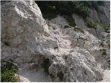 40
40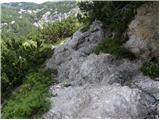 41
41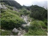 42
42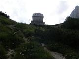 43
43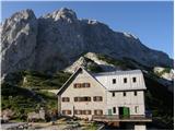 44
44 45
45 46
46 47
47 48
48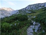 49
49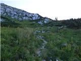 50
50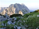 51
51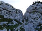 52
52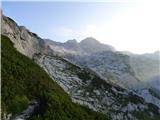 53
53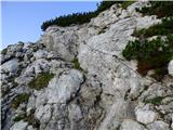 54
54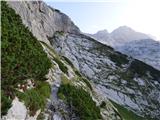 55
55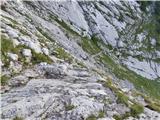 56
56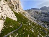 57
57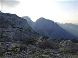 58
58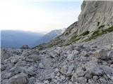 59
59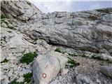 60
60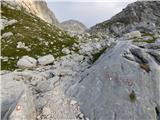 61
61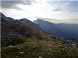 62
62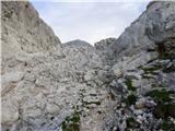 63
63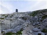 64
64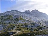 65
65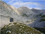 66
66
Discussion about the trail Suhadolnik - Bivak pod Grintovcem
|
| Guest16. 06. 2007 |
 Enkratna tura
|
|
|
|
| Guest16. 06. 2007 |
Ja meni je bila tudi všeč in dalje na Grintovec skoz lepa. Kako je pa če greš pri stari Frischavfovi koči levo proti Kočnam (čez Grdi graben al tak nekak)
|
|
|
|
| Guest11. 07. 2007 |
še lepše  
|
|
|
|
| Guest11. 07. 2007 |
pa bolj nevarno
|
|
|
|
| Guest25. 07. 2007 |
se strinjam, bolj zahtevno in izpostavljeno! Velika nevarnost zdrsa !
|
|
|
|
| velkavrh18. 06. 2011 |
Danes je bil moj končni cilj bivak, ker je bilo preveč megle in snega za varen pohod na Skuto. Žal je bil tudi bivak skoraj skrit v megli, tako, da niti dobrega posnetka nisem mogel narediti. V njem so bili štirje Čehi, tako, da si tudi na prvi pogled lepe in uporabne notranjosti nisem mogel pogledat. Pa kdaj drugič
|
|
|
|
| svetilka22. 07. 2013 |
Zelo lepa tura. V poletnem casu prav idilicno, malce bolj tezaven odsek se nahaja pri precenju, kot je prikazano na sliki 53 oz. nekoliko zatem. Tam je cca. 100-200m dokaj nevarnih, bi bil planinec vesel kaksne dodatne zajle.
|
|
|
|
| Nosko14. 09. 2014 |
Ali so na tem odseku že dodane zajle?
|
|
|
|
| rodica14. 09. 2014 |
Na tem odseku so 2 ali 3 jeklenice dolge po par metrov. Mislim, da je ze par let enako.
|
|
|
|
| Branee14. 09. 2014 |
zakaj bi pa pobocje jurjevo potrebovalo jeklenico?
|
|
|
|
| jax14. 09. 2014 |
No, tisto dejansko je dokaj izpostavljen prehod po terenu s podlago dokaj slabe kvalitete, tako da vprašanje o kakih varovalih ni popolnoma nevmesno. Je pa to konec koncev vprašanje meril pri nameščanju varoval. Upam si trdit, da bi bil marsikje v Julijcih tak prehod varovan, ampak mislim, da je večina pohodnikov že opazila, da so Kamniške v celoti pač nekaj manj varovane. Zdaj, kateri pristop je "boljši" ali "primernejši", je seveda popolnoma odvisno od preferenc posameznika.
|
|
|
|
| Branee14. 09. 2014 |
se mal pa bojo potreboval gondole..
|
|
|
|
| Nosko17. 09. 2014 |
No super, bo treba jit pogledat Leta 2012, ko sem šel prvič do bivaka, jih še ni bilo.
|
|
|