Rutarski gozd - Jehlc (Špičasta kupa)
Starting point: Rutarski gozd (1030 m)
| Lat/Lon: | 46,2156°N 13,8895°E |
| |
Time of walking: 2 h
Difficulty: easy unmarked way
Altitude difference: 632 m
Altitude difference po putu: 700 m
Map: TNP 1:50.000
Recommended equipment (summer):
Recommended equipment (winter): ice axe, crampons
Views: 6.743
 | 2 people like this post |
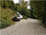
Access to the starting point:
From Podbrdo drive to Tolmin or vice versa, but only as far as the village of Koritnica. At Koritnica you will see a sign for the village Rut, which points to the right (from Tolmin, take a sharp left). Follow the mostly ascending road to the village, where there is also a small crossroads. Continue straight ahead (Grunt village on the left) along the road, which soon loses its asphalt surface. The wide macadam road quickly climbs above the village and turns right. Three serpentines follow, at the third or second left we are joined on the right by the marked path from Stržišče, and from here on we become alert to possible parking on the roadside, as driving is prohibited from the next junction onwards.
Path description:
From the parking lot, continue along the dirt road, then quickly reach an unmarked junction where you continue along the upper right-hand road, which has a ramp and a road sign prohibiting further traffic. The road continues to climb steeply and slowly turns into a wide, mostly rocky cart track, which soon leads past a hunting observatory to a crossroads, where we continue right in the route Rodica (straight mountain pasture Razor). Continue along the relatively well-preserved mulatier, first through the forest and then through dwarf pines. Moderately steep and increasingly scenic, the path then crosses a few ravines and gets closer and closer to the summit (Jehlc), which we have been loking at for some time. After about an hour and a half of walking, the marked trail almost reaches the ridge. Here, at a height of about 1700m, where you can see cairn and a faint path ascending to the left on the ridge, you leave the marked path leading to Rodica.
Next, climb up the ridge in a few steps and follow it to the left, where you will quickly reach the lookout head (Peči or Ridge 1727 m). The head opens up a beautiful view towards Jehlcu, which is separated by a short steep descent and then a folded climb up the lookout ridge. From the place where we left the marked path to the top of Jehliec, we follow a less good path, which runs along and partly along the ridge.
The path is not difficult, but orientation is difficult in the fog.

Pictures:
 1
1 2
2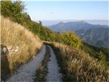 3
3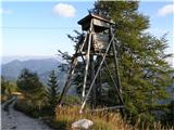 4
4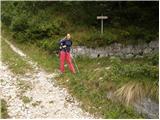 5
5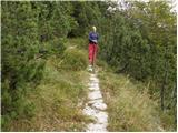 6
6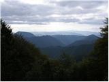 7
7 8
8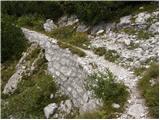 9
9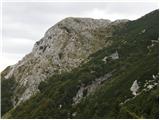 10
10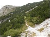 11
11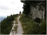 12
12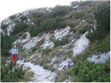 13
13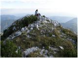 14
14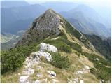 15
15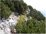 16
16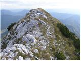 17
17 18
18
Discussion about the trail Rutarski gozd - Jehlc (Špičasta kupa)
|
| grega_p7. 09. 2014 |
Res mi je v veselje, da se na tem forumu najdejo opisi posameznih neobičajnih vrhov, ki so pogosto deležni precej manj obiska kot rdeče črte na zemljevidih, pa čeprav so v njihovi bližini.
Današnji izlet v južni svet Bohinjskih gora je bil res lep. Brez premočnega sonca, prijetna pot in polno malin ob njej (jih ljudje spregledajo, ko iščejo cilj z očmi?)
Nekaj komentarjev pa vseeno:
- z avtom se ne de vse do konca, kot je tu v opisu (pred tem je znak za prepoved vožnje, rampa je sicer odprta), tako da (po pravilih) štartamo z nekje cca 1050m
- zadnji kratki strmi del pri vzponu na greben v mokrem zahteva nekaj pazljivosti (če se odločimo za vzpon pri prvem kamnitem možicu, cca 1620 n.m.v)
- na zemljevidu Bohinj (Sidarta, 1:25.000) je označen Jehlc en vrh višje 1727 (naslednja glava v grebenu), ta pa ima ime Špičasta kupa
- zaradi težav domačinov z divjimi prašiči (pravijo, da radi vrtnarijo) in jelenjadjo (ki okuša sadna drevesa), so na terenu lovci. Po pogovoru z enim izmed njih, jagajo pozno pop/zvečer, ko je najboljši čas. Toliko za opozorilo.
Z andrhtjo in srcem.
To velja tudi za gore,
pa srečno...
|
|
|