Ročinj - Sveti Pavel (above Ročinj) (past sacred signs)
Starting point: Ročinj (199 m)
| Lat/Lon: | 46,10963°N 13,67107°E |
| |
Name of path: past sacred signs
Time of walking: 35 min
Difficulty: easy marked way
Altitude difference: 204 m
Altitude difference po putu: 212 m
Map:
Recommended equipment (summer):
Recommended equipment (winter):
Views: 371
 | 1 person likes this post |
Access to the starting point:
From Nova Gorica drive to Tolmin or vice versa, follow the road to Ročinj, where you can park in a suitable place.
Path description:
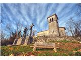
The starting point of the route to St Paul's Church is in the centre of Ročinj by St Andrew's Church.
First, the path descends to the spring of Zdenc, from here continue along the path on the left, after a good hundred metres you reach a stream, where you continue straight on and cross the stream over a small bridge (marked with a direction sign to St. Paul). Continue on the gently ascending path and at the first fork go left, when you come to the second fork, continue on the right path (marked by the signpost St. Paul past the signs). The path rises quite steeply and you can see the remains of three signs along the way. After a good 15 minutes, you will see the Church of St Paul with the Calvary.
Pictures:
 1
1
Discussion about the trail Ročinj - Sveti Pavel (above Ročinj) (past sacred signs)