Predel - Cime del Mughi / Nemške glave
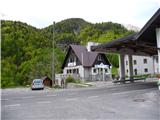
Starting point: Predel (1156 m)
| Lat/Lon: | 46,4186°N 13,5783°E |
| |
Time of walking: 1 h 30 min
Difficulty: partly demanding unmarked way
Altitude difference: 441 m
Altitude difference po putu: 441 m
Map: Tabacco 019, Julijske Alpe - zahodni del 1:50.000
Recommended equipment (summer):
Recommended equipment (winter): ice axe, crampons
Views: 13.102
 | 3 people like this post |
Access to the starting point:
From Ljubljana take the Gorenjska motorway to the Hrušica exit. From there, follow the regional road to the Rateče border crossing and onwards to Trbiz. Shortly before it, the road to the Predel border crossing turns off to the left. Pass through the mining village of Rabelj and continue for a few kilometres to the Predel / Sella Nevea crossroads. Turn left and after a few more kilometres you will reach the border crossing. From Ljubljana to Predel takes about 1 hour and 30 minutes. Park on the Slovenian side, where there is plenty of space.
The starting point can also be reached from the route of Bovec.
Path description:
The unmarked trail starts on the Italian side of the border crossing just after the border stone (obelisk) in the direction of Jerebica. The path is not visible along the edge of the meadow, but appears when you get into the forest. It is clearly visible and good enough not to cause any problems, although it has seen better days. Care is needed in the two rocky ravines so as not to miss the continuation (see pictures). The path up to the summit plateau is steep, but as you get higher, beautiful views open up far and wide. On the summit plateau, the dwarf pines plantations start, requiring some squatting, but the path is still traceable. The highest peak is the last in the chain and has a fort on its right edge. It is reached via a slightly more difficult notch, which has a detour on the right-hand side. This detour is not much easier, but it starts in a gully just before the notch. There is then a bit of a climb to the top and you come to a clearing in the middle of dwarf pines. As there is no other view here than on Jerebica, head right towards the fort. Access is not quite easy because of the overgrown nature of the path, but it can be followed with a little effort. It runs from the clearing onwards along the deciduous border and dwarf pines. When you reach the fortress, you have an extraordinary view towards Rabl and the Neveu Pass / Sella Nevei.
On the way back, more care is needed when following the path.

Pictures:
 1
1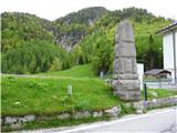 2
2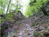 3
3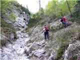 4
4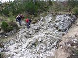 5
5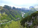 6
6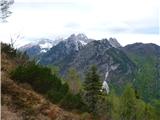 7
7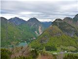 8
8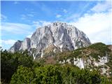 9
9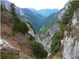 10
10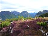 11
11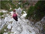 12
12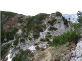 13
13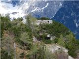 14
14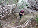 15
15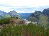 16
16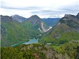 17
17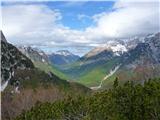 18
18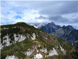 19
19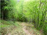 20
20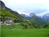 21
21
Discussion about the trail Predel - Cime del Mughi / Nemške glave
|
| Loerst9. 05. 2018 |
Sicer povsem korektnemu opisu bi dodal samo to, da danes (maj 18) pot na kar nekaj odsekih ni razvidna in se jo zelo hitro zgreši (gor in dol). Tudi nekaj mest je, kjer je tudi v suhem terenu nekoliko drsno. Sicer nič takega, kar ne bi povprečen pohodnik z malce improvizacije rešil (pač, gor je treba, lahko tudi po kakšni grapi ali malo po svoje naokoli), ampak ker je zgoraj precej zaraščeno se odmik iz poti hitro maščuje z lomastenjem skozi šavje, kar pa potem ni več tako simpatičen izlet, kot bi sicer lahko bil.
|
|
|
|
| keti111. 05. 2018 |
Se strinjam, da pot ni enostavno sledljiva in je ne bi priporočala manj izkušenim. Pred cca 15 leti sem bila gor nekajkrat, vedno brez težav. Nazadnje l. 2016 pa sem se na nekaj mestih precej lovila, tudi pri povratku ni bilo enostavno. Nikakor pa ni primerna v megli.
|
|
|
|
| inferno66630. 07. 2019 |
Prejšnji teden sem se z boljšo polovico podal po tej poti. Pot je na začetku lepo sledljiva, potem pa sva na neki točki zašla. Pot med sliko 4 in 12 sva midva opravila po brezpotjih in delno po poti, ki ni opisana tukaj  . Za vračanje pa sva našla pot, ki je za moje pojme najlažja tudi za vzpon. Pri škrbini sva zavila v dolino proti rabeljskem jezeri. Pot gre najprej po levi strani, kasneje pa po desni strani potoka. Z zgodaj opisano potjo se združi 10 min pred izhodiščem. Na poti ni tehnično zahtevnih delov. Opazila sva, da je pot označena s puščico, ki pa sva jo midva spregledala. Razcep se pojavi po cca 10-15 min od izhodišča. Prilagam še sliko.
|
|
|
|
| skiro12331. 08. 2020 |
Pot prehodil pred nekaj dnevi in kar nekaj informacij ni najbolj točnih:
1) Spust v škrbino je zahteven, vsaj toliko kot npr. Mali Draški vrh, zato bi bila bolj primerna oznaka zahtevna neoznačena steza.
2) Vrh, ki je opisan kot "vršna planota" je na nekaterih zemljevidih označen Veliki Koteh - do tja je oznaka delno zahtevna povsem primerna.
2) Za pot se primerljivo z drugimi časi hoje potrebuje 2 uri, razen če je mišljen Veliki Koteh.
3) Dostop z vrh Nemških glav do utrdbe ni zatheven.
Vse skupaj je verjetno nesporazum zaradi nejasnosti kako se imenuje vrh. Peakvisor in opencyclemap imata vrh označen kot Veliki Koteh (1578), pespoti.si pa Nemške glave, brez oznake višine. Adminu predlagam popravek ali v spremembo imena vrha (in višine) ali pa v opisu.
|
|
|
|
| Loerst29. 03. 2021 |
Veliki Koteh (1578 m) in Nemške glave (1597 m) sta dva različna vrhova na praktično isti lokaciji, oddaljena zračne črte cca 300 m oz. nekaj minut zaradi vmesnega spusta v škrbino. Veliki Koteh je še pred spustom v škrbino in Nemške glave so za njo, bližje Jerebici. Ker je slednji vrh višji, pa se pogosteje navaja samo Nemške glave. Na nemških zemljevidih je ponekod tudi oznaka leva oz. desna glave (linker oder rechter Kopf).
|
|
|
|
| darinka426. 06. 2025 19:31:06 |
Res je .So dali tablico z napisom vrha. Mi trije smo bili danes prvič po teh poteh. Težav pri iskanju poti sploh nismo imeli.Pa tudi nikogar ni bilo na poti. Pot se nam je zdela enostavna. Brez kakšnih iskanj, kot smo običajno navajeni na naših brezpotnih turah. Razgledi so bili malo okrnjeni, a Jerebica je bila čisto blizu. Ogledali smo si Planjo, a se nismo odločili za vzpon. Na koncu ture pa še do Rabeljskega jezera, kjer ni bilo prav nobene gneče. Voda pa čisto v redu za plavanje. Cesto na italianski strani popravljajo. Je semafor . A ni težav. Kot pri nas počakaš na zeleno luč.
|
|
|