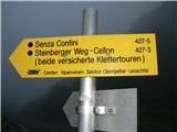
Plockenpass - Creta di Collinetta / Cellon (Ferata Senza Confini)
Starting point: Plockenpass (1360 m)
| Lat/Lon: | 46,6027°N 12,9447°E |
| |
Name of path: Ferata Senza Confini
Time of walking: 3 h 45 min
Difficulty: extremely difficult marked way
Ferata: D
Altitude difference: 878 m
Altitude difference po putu: 880 m
Map: Tabacco 09
Recommended equipment (summer): helmet, self belay set, lamp
Recommended equipment (winter): helmet, self belay set, ice axe, crampons, lamp
Views: 13.229
 | 4 people like this post |
Access to the starting point:
From Ljubljana, take the Gorenjska motorway, exit Hrušica, continue via the Rateče border crossing to Trbiz. There, turn onto the motorway, leaving at the Tolmezzo exit. Take the second exit at the roundabout and continue in the direction of Passo di Monte Croce ( Plockenpass), passing the towns of Arta Terme, Paluzza, and Timau. From here on, the road begins to rise steeply and in the upper part, with its serpentine winding roads, it will make your hands and the steering wheel of the car wobble. We drive to the top platform of the pass, where we can park. The whole journey from Ljubljana to the parking lot takes 2 hours and 30 minutes.
The route across the Ziljska Valley is 10 minutes shorter.
Path description:
From the parking lot, continue in the direction of Austria (wind farm) and on the left edge of the upper road you will see the yellow trail markers for the "Senza Confini" ferrata marked 427-5. The path ascends gently up the hill on the right to the next turning, where you take the "Sentiero Storico" option. This passes through a tunnel built for supply purposes during the First World War, and here you can see for yourself the follies that were done to maintain strategic positions at the time. The tunnel is high enough to walk through normally, but it is very steep and mostly unprotected. It has to negotiate 100 elevations over a length of about 200 m and is impassable without a lamp. The 'Sentiero Storico' is simply a must and I highly recommend it.
After leaving the tunnel, there is a short climb up to the Schulter ridge just below our destination, where signs point us back in our direction. However, care must be taken as we continue around the ridge towards the "Senza Confini" ferrata. The markings are not always clear enough and it is possible to get lost. Our direction is the wall above us, the left side with a sloping drop, to which there is a small scree slope. Here we will catch the markings again. Before entering the ferrata there is a board with a marking and explanation of the direction and information about equipment and emergency calls (it is wise to save these numbers in your mobile so that in case of an accident you do not waste time trying to find out the correct numbers). Equip yourself with a helmet, climbing gloves and self-protection equipment.
Ferato is not easy to describe. It is extremely varied and there is something for everyone. The initial boulders above the warning sign warm us up and get us limbered up for the first big challenge. Ahead of us is a very steep, smooth plateau with no end in sight. It is equipped with crampons, and the easiest way to get to grips with it is to hold a rope between your legs and pull yourself up the slab by pulling and stepping between the crampons. At its top, the ferrata turns into a mostly ridge traverse, which is difficult to describe. There is a constant alternation of climbs, transitions and traverses. The difficulty here reaches all grades from A to D. Exposure is mostly extreme, with deep vistas below us. The Fixed safety gear are good, the rock excellent. We progress quickly and soon see a peak with a cross. The ferrata ends just below it. Further along the route to the finish we can see the remains of military positions. At the top we can congratulate ourselves.
DESCEND: The easiest way down is via route 147 on the western slopes. To find the start of the route, first return to the crossroads at the top of the route that you met on the ascent. Take the right-hand path and continue descending. Always choose the downward direction at the crossroads. After crossing a rocky slope, the path turns into a good mulatier, crossing grassy slopes at an angle. Care should be taken at the fork in the path for the Schulter ridge and the tunnels that can be seen ahead. This is not the place to go. Our route turns down a little before them and joins route 146 a little lower down. We continue along the valley towards our starting point at the Plockenpass.

Pictures:
 1
1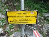 2
2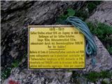 3
3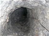 4
4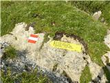 5
5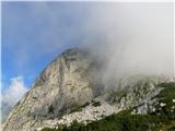 6
6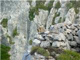 7
7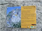 8
8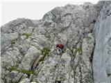 9
9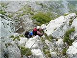 10
10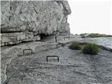 11
11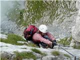 12
12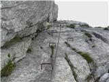 13
13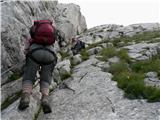 14
14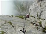 15
15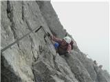 16
16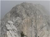 17
17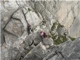 18
18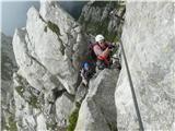 19
19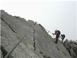 20
20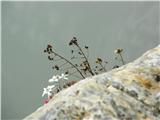 21
21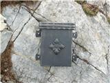 22
22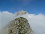 23
23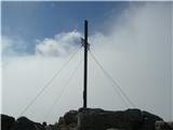 24
24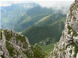 25
25 26
26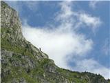 27
27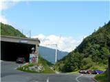 28
28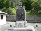 29
29
Discussion about the trail Plockenpass - Creta di Collinetta / Cellon (Ferata Senza Confini)
|
| mikk31. 07. 2010 |
Čudovit opis...
Mene zanima koliko časa ste potrebovali vse skupaj, gor-dol z postanki?
|
|
|
|
| bagi31. 07. 2010 |
Mikk. Vse skupaj nekaj manj kot 8 ur predvsem na račun zelo zanimive poti, fotkanja in uživanja v razgledih tako v globino, kot v višino  Lahko prideš v cca 7 urah, vendar na taki lepi poti doseganje hitrostnih rekordov nima nobenega smisla. LP Bagi
|
|
|
|
| bandy1. 07. 2012 |
Preplezal omenjeno ferato. Treba je omeniti ,da je nova ferata v vstopu , kar omogoča lepo krožno turo( po novi ferati gor,Ferata Senza Confini, sestop po poti 147 in potem v rov v povratku), kar je dosti lažje ( rov je zelo spolzek in je sestop po njem zato lažji). Zelo priporočam omenjeno turo, je pa kondicijsko zahtevna. Bagi zelo dober opis , mi je zelo pomagal
|
|
|
|
| mirank1. 07. 2012 |
Gornjemu zapisu bi pripomnil, da se mi približno 5urna tura ne zdi niti malo kondicijsko zahtevna. Zagotovo pa je vzpon po spolzkih skalah v kaverni oz galeriji definitivno lažji od spusta-oboje preverjeno pred kakim mesecem. Ne glede na to je to samo moje skromno mnenje in naj presodi vsak sam skladno s svojimi izkušnjami; srečno
|
|
|
|
| borlepadrino30. 08. 2016 |
Ferrata brez meja je tezja ali lazja v primerjavi s zacetnim delom ferrate 26 za na coglians???
|
|
|
|
| don kihott1. 09. 2016 |
Weg der 26er je najzahtevnejša ferata v Karnijskih alpah...
|
|
|