Planina Podvežak - Veliki vrh (Veža) (via Prag)
Starting point: Planina Podvežak (1500 m)
| Lat/Lon: | 46,3319°N 14,6726°E |
| |
Name of path: via Prag
Time of walking: 2 h 20 min
Difficulty: easy marked way
Altitude difference: 610 m
Altitude difference po putu: 750 m
Map: Kamniške in Savinjske Alpe 1:50.000
Recommended equipment (summer):
Recommended equipment (winter): ice axe, crampons
Views: 52.898
 | 5 people like this post |
Access to the starting point:
First drive to Luče, then continue into the Podvolovjek valley (direction Kamnik and Kranjski Rak). At the road marker between 11 and 11. 5 km, you will come to a small crossroads where the road to the right branches off towards Farmer Planinšek and the mountains Podveža, Ravne and Vodole (the branch is marked). Take this initially still asphalted road and follow it at the crossroads in the route mountain pasture Podveža. After a relatively long and in the upper part also worse macadam road you will reach the parking lot under mountain pasture Podveža (at the starting point there is a ramp and a number of mountain signs).
From Kamnik, drive towards the Črnivec Pass, but only as far as the crossroads, where the road to Kranjski Rak turns sharp left (the turn-off is marked and is located only 500 m before the pass). At the crossroads at Kranjski Rak, continue straight ahead on the main road, which starts descending into the Podvolovjek valley. In the valley, just 100 m after the Gams bar, you will reach a crossroads where the road to the left branches off towards the farmer Planinšek and the Podveža, Ravne and Vodole mountains (the branch is marked). Follow the description above.
Path description:
From the parking lot, take the footpath (or road) in the route mountain pasture Podveža. Both the road and the footpath, which crosses a forest road during the ascent, lead us in 15 minutes of moderate ascent to the shepherd's hut at mountain pasture Podveža, from which we have a beautiful view towards Rogatec and Lepenatka.
From mountain pasture continue along the marked, but at first less visible path, which soon goes into the forest. The path through the forest climbs a little steeper and then enters a small uncultivated valley, above which it completely flattens out. It is followed by a few minutes of crossing the slopes below the side ridge of the board, and then the path leads to a less visible crossroads, where an unmarked path branches off to the left, leading towards Deska and the Watercourse Lake. Continue straight on the marked path, which descends into a pleasant grassy plain, then turns slightly to the right and climbs through the dwarf pines zone. At the top of the climb, the path with the mountain pasture Vodole joins from the right, and we continue left, crossing a pasture fence and after a few further steps we reach the Inkret's Well, which is located just a few metres off the path.
There is only a slight climb, and then the path lies down again and leads us under the relatively steep and avalanche-prone slopes of Tolstego vrh (Tolstego Peak). A little further on, a pleasant path leads us to a marked crossroads, where we continue slightly to the right in the direction of the chapel on Molička peč (slightly to the left Korošica). The way forward descends slightly, then continues in a moderate ascent over a series of several small valleys. Soon there is a small crossroads where a path branches off to the left, returning to the marked path towards Korošica, and to the right the path towards mountain pasture Ravne and Dolga Trata. We continue straight along the wide and pleasant path, which after a few minutes of further walking leads us to the Prag preval, where the next crossroads is.
We continue to the sharp right in the direction of mountain pasture Ravne and Velika peak (straight ahead Molička mountain pasture) on the path which crosses the slopes of Velika peak to the south-east. After a few minutes of further walking, you will notice a small wooden signpost by the side of the path, with the inscription Velika vrh, which directs you to the left to a slightly less visible path that climbs through the dwarf pines zone. Higher up, the path becomes slightly more distinct and gradually starts to climb steeper and steeper. The rather steep path, along which a number of cairns are used to help orientation, starts to disappear higher up. Next, follow the less visible path, which changes from a steep partly rocky part to more grassy slopes. After a few minutes of further walking, the less visible path, which slowly turns to the right, leads us to the Velika summit where we see a large cairn.

Pictures:
 1
1 2
2 3
3 4
4 5
5 6
6 7
7 8
8 9
9 10
10 11
11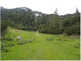 12
12 13
13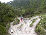 14
14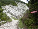 15
15 16
16 17
17 18
18 19
19 20
20 21
21 22
22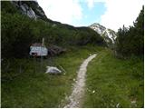 23
23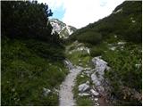 24
24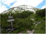 25
25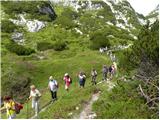 26
26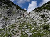 27
27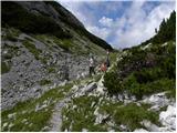 28
28 29
29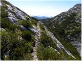 30
30 31
31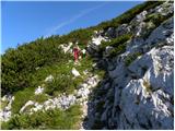 32
32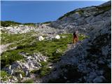 33
33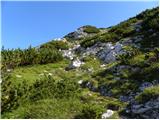 34
34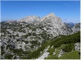 35
35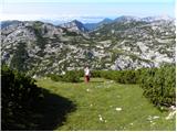 36
36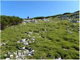 37
37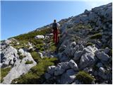 38
38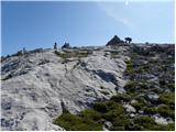 39
39 40
40
Discussion about the trail Planina Podvežak - Veliki vrh (Veža) (via Prag)
|
| ruševec14. 08. 2011 |
Včeraj bil na Velikem vrhu iz planine Podvežak prek sedla Prag. Ker v vseh planinskih vodnikih, vseh kartah in celo tukaj na hribi.net piše, da je to neoznačena steza, me je presenetilo. Na mestu, kjer naj bi bil odcep iz poti Prag-Planina Ravne proti vrhu zelo lepo označeno razpotje. Vsa pot do Velikega vrha pa na novo markirana! Pri tem se mi pojavi vprašanje, ali je sploh dovoljeno na novo označevati planinske poti?
|
|
|
|
| starakapa18. 09. 2011 |
Prvega junija letos pot še ni bila markirana
|
|
|
|
| otiv18. 09. 2011 |
@MajaO Lesena tablica je bila nekaj korakov naprej in začetek poti.Mislim,da Veliki vrh z markacijam ni ničesar izgubil,morda le nekaj več obiskovalcev pridobil. 
|
|
|
|
| kicho31. 08. 2012 |
Včeraj opravil to turo, markirano, pot urejena, razgled na vrhu pa fantastičen.
|
|
|
|
| pohodnik3818. 09. 2012 |
Že nekaj časa nazaj(9.9.) prehodil tole pot,razgled je res enkraten z Velikega vrha potem pa še nadaljeval proti Korošici na Lučkega dedca in naprej še pogledat Vodotočno jezero...lepa krožna turca VIDEO-Dleskovška planota
|
|
|
|
| Grenaleva7. 07. 2014 |
Pot ne Veliki vrh čez Podvežak ima res še veliko snega, ki ni nevaren, ampak nudi lepe zimske užitke sredi poletja.
|
|
|
|
| zokipoki7. 09. 2014 |
Včeraj bil na vrhu. Pot od razpotja (Molička peč 30min-levo/Veliki vrh-desno)je enostavno čudovita. Strma in lepo označena, tako da kljub včerajšni gosti megli z orientacijo ni bilo težav.
Prvič, da sem bil sam na vrhu gore odet v gosto meglo....občutek je nekaj posebnega.
lepa tura.
|
|
|
|
| Mirna16067. 10. 2018 |
Pozdrav, u kakvom je stanju cesta do Planine Podvezak?
|
|
|
|
| garmont7. 10. 2018 |
Tako kot vsako leto konec sezone.
Malce razrita, ampak do parkirišča se da priti z vsakim avtom.
|
|
|
|
| alesfon30. 06. 2021 10:39:06 |
Včeraj prehodil to pot in je normalno prehodna brez zimske opreme. Na poti je eno snežišče, ki ga obhodiš po levi strani.
Na vrhu je polno rožic.
|
|
|
|
| Lenore12. 09. 2021 11:07:22 |
Delam transverzalo, ampak mi ni jasno, kje je žig tu gori? Sta 2 skrinjici (ena ob kupu kamenja, druga z miniaturni obliki Aljaževega stolpa).. sicer v obeh žig (enak!) nekega planinskega društva.. ni pa žiga za transverzalo. 
|
|
|
|
| Gorazd G12. 09. 2021 12:30:00 |
Na vrhovih se v dnevnik odtisnejo "običajni" žigi vrhov. To popolnoma zadostuje pravilom. "Posebni" žigi SPP so samo v planinskih kočah.
|
|
|
|
| mirank12. 09. 2021 16:56:13 |
Od kdaj pa je ta vrh v transverzali?
|
|
|
|
| garmont12. 09. 2021 19:29:48 |
Ni ta Veliki...ampak oni v Karavankah. 
|
|
|
|
| franca12. 09. 2021 19:58:36 |
Ne, ta v KS je. Številka 13 b (13 a je Mrzla gora), višina 2110 m. Knjižica iz 2020, od kdaj velja, pa ne vem.
|
|
|
|
| Enka12. 09. 2021 20:12:12 |
V moji sta oba (oba na razširjeni).
|
|
|
|
| garmont12. 09. 2021 20:46:42 |
V moji pa prvi…je malce starejša. 
|
|
|
|
| Tajka6731. 05. 2025 21:51:23 |
Super lep izlet, le v zgornjem delu je treba pot kar posteno iskat. Cesta je na novo nasuta, lukenj nikjer, pohvalno. Kljub čudovitemu vremenu v tej smeri skoraj nikogar. Sem podaljšala še do kapele na Molički planini
|
|
|
|
| nkamin13. 08. 2025 10:06:45 |
Prosim za informacijo o stanju poti do planine Podvežak
|
|
|
|
| garmont13. 08. 2025 11:38:21 |
Če sprašuješ o cesti, je povsem v redu. Tudi za nižja vozila.
|
|
|
|
| nkamin13. 08. 2025 16:05:41 |
Ja, sprašujem o cesti . Hvala za sporočilo.
|
|
|