Planina Podvežak - Planjava (via Srebrno sedlo)
Starting point: Planina Podvežak (1500 m)
| Lat/Lon: | 46,3319°N 14,6726°E |
| |
Name of path: via Srebrno sedlo
Time of walking: 4 h 15 min
Difficulty: difficult marked way
Altitude difference: 892 m
Altitude difference po putu: 1100 m
Map: Kamniške in Savinjske Alpe 1:50.000
Recommended equipment (summer): helmet
Recommended equipment (winter): helmet, ice axe, crampons
Views: 60.028
 | 2 people like this post |
Access to the starting point:
First drive to Luče, then continue into the Podvolovjek valley (direction Kamnik and Kranjski Rak). At the road marker between 11 and 11. 5 km, you will come to a small crossroads where the road to the right branches off towards Farmer Planinšek and the mountains Podveža, Ravne and Vodole (the branch is marked). Take this initially still asphalted road and follow it at the crossroads in the route mountain pasture Podveža. After a relatively long and in the upper part also worse macadam road you will reach the parking lot under mountain pasture Podveža (at the starting point there is a ramp and a number of mountain signs).
From Kamnik, drive towards the Črnivec Pass, but only as far as the crossroads, where the road to Kranjski Rak turns sharp left (the turn-off is marked and is located only 500 m before the pass). At the crossroads at Kranjski Rak, continue straight ahead on the main road, which starts descending into the Podvolovjek valley. In the valley, just 100 m after the Gams bar, you will reach a crossroads where the road to the left branches off towards the farmer Planinšek and the Podveža, Ravne and Vodole mountains (the branch is marked). Follow the description above.
Path description:
From the parking lot, take the footpath (or road) in the route mountain pasture Podveža. Both the road and the footpath, which crosses a forest road during the ascent, lead us in 15 minutes of moderate ascent to the shepherd's hut at mountain pasture Podveža, from which we have a beautiful view towards Rogatec and Lepenatka.
From mountain pasture continue along the marked, but at first less visible path, which soon goes into the forest. The path through the forest climbs a little steeper and then enters a small uncultivated valley, above which it completely flattens out. It is followed by a few minutes of crossing the slopes below the side ridge of the board, and then the path leads to a less visible crossroads, where an unmarked path branches off to the left, leading towards Deska and the Watercourse Lake. Continue straight on the marked path, which descends into a pleasant grassy plain, then turns slightly to the right and climbs through the dwarf pines zone. At the top of the climb, the path with the mountain pasture Vodole joins us from the right, and we continue left, crossing a pasture fence and after a few further steps we reach the Inkret's Well, which is located just a few metres off the path.
There is only a slight climb, and then the path lies down again and leads us under the relatively steep and avalanche-prone slopes of Tolstego vrh (Tolstego Peak). A little further on, a pleasant path leads us to a marked crossroads, where we continue slightly left in the direction of Korošice (slightly right, the chapel on Molička peč (mountain)). The path continues for some time crossing the slopes below Tolstim vrh, and then passes onto the plateau-like world of the Dleskovška plateau, which is interspersed with numerous potholes and caves. The path, which continues with a few short ascents and descents, then quickly leads us to a crossroads, where the path from Robanov Kot and mountain pasture Ravne joins us from the right.
Continue in the direction of Korošica along the path which ascends crosswise to the saddle between the lesser-known Koroška vrh on the left and Mala Ojstrica on the right. Continue straight down (Prag on the left, Ojstrica over Mala Ojstrica on the right) on the marked trail which starts descending towards Koroška. After a few minutes of descending, you will reach the vast grassy slopes of Korošica, which you can then walk along in a few minutes to the mountain lodge. From Kocbek's home continue in the direction of Planjava and Kamnik saddle. The way forward is initially slightly downhill, then a series of small valleys in a slight ascent leads us to a steeper part of the route. The path then climbs up along the ravine and only crosses it at a higher level. As we climb, more and more views open up and a natural window catches our eye. The path then switches from grassy to rocky slopes, where you quickly reach the sheltered part of the path. The well-protected and sometimes quite steep path then leads us to Srebrno sedlo, where a beautiful view of the Kamnik side opens up. Then cross the slopes to the west at a moderate incline. We then come to the next crossroads, where we continue to the right towards the top of Planjava (Kamniško sedlo on the left). The green meadows are finally bidding farewell to the increasingly scenic route, replaced by grey rock. Just below the summit, the paths from Klemenča jame and Kamnička sedlo join up. There is only a short climb up the top slope of the mountain.
Podveža - Korošica 2:15, Korošica - Planjava 2:00.

Pictures:
 1
1 2
2 3
3 4
4 5
5 6
6 7
7 8
8 9
9 10
10 11
11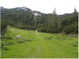 12
12 13
13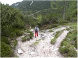 14
14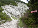 15
15 16
16 17
17 18
18 19
19 20
20 21
21 22
22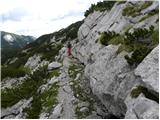 23
23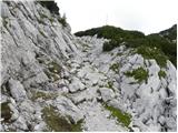 24
24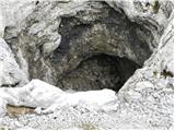 25
25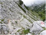 26
26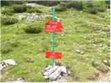 27
27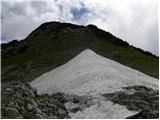 28
28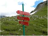 29
29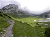 30
30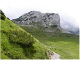 31
31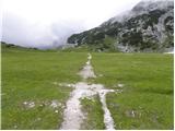 32
32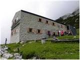 33
33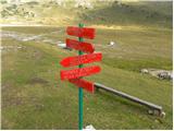 34
34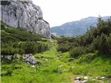 35
35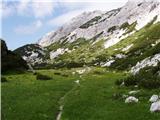 36
36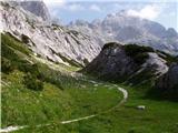 37
37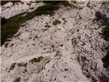 38
38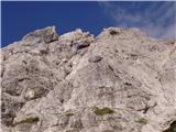 39
39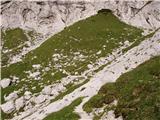 40
40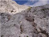 41
41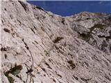 42
42 43
43 44
44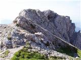 45
45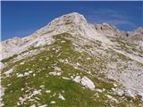 46
46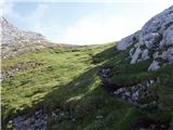 47
47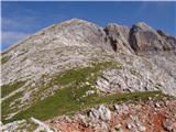 48
48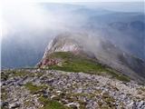 49
49 50
50
Discussion about the trail Planina Podvežak - Planjava (via Srebrno sedlo)
|
| lepenatka17. 06. 2011 |
Pozdravljeni,
je kdo te dni hodil po zgoraj omenjeni poti?
Kakšne so kaj razmere?
LEP pozdrav vsem
|
|
|
|
| Betoner18. 07. 2012 |
Včeraj lepo vreme, , pri Korošici sta 2 majhni ovčki, vzpon na Planjavo pa je kr hud klanec.
|
|
|
|
| tiffernus25. 11. 2012 |
Danes je bilo za konec novembra res neverjetno vreme - soncek, skoraj povsem brez vetra, okoli 10 C. Pod vrhom je nekaj zaplat snega, ki pa ne ovirajo hoje. Lep izlet.
|
|
|
|
| baxon12. 09. 2013 |
Zdravo,
zanima me če je na tej poti kaj klinov in če je kaj prepadna?
Hvala za odgovor
|
|
|
|
| otiv3. 09. 2013 |
@baxon1 poglej zgoraj slikce 41 in 42 in boš videl situacijo. Na tem delu je pot strma,ni pa prepadna.
Srečno!
|
|
|
|
| Rokovnjacica3. 09. 2013 |
kje na zgoraj omenjeni poti in na zgornjih slikah je Srebrno sedlo? In kako se pride do njega iz kamniškega konca po dolini Bele? 
|
|
|
|
| Rokovnjacica3. 09. 2013 |
in še ali je pot primerna tudi za vrtoglave?
|
|
|
|
| otiv3. 09. 2013 |
Srebrno sedlo je na sliki 45 in 46 do njega prideš po poti s Korošice,če imaš namen iti preko Presedljaja.Če je vrtoglavica prisotna,pa odsvetujem pot,še posebno če hodiš sama.
Srečno!
|
|
|
|
| Rokovnjacica3. 09. 2013 |
Otiv hvala!Če je strmina me ne skrbi, skrbijo me prepadi. 
|
|
|
|
| Rokovnjacica3. 09. 2013 |
A so ob poti prepadi al jih ni?  Prosim Otiv še to mi povej...
|
|
|
|
| ločanka24. 07. 2016 |
Lepa pot, sploh spodnji del nad Petkovimi njivami je v tem času poln cvetja, pravi botanični vrt. Tistim, ki jim je pa hoja po strmem šodrastem svetu neugodna in jim rado spodrsuje, bi pot navzdol odsvetovala. Srebrno sedlo pa krasno mesto za posedanje in uživanje!
|
|
|
|
| Dariny27. 12. 2017 |
a je to težka pot, prepadna? hvala...poleti se imam namen odpravit gor...hvala 
|
|
|
|
| geppo28. 12. 2017 |
Pot ni težka ali izpostavljena. Je sicer nekaj klinov in zajl ko se od Korošice vzpenjaš proti Srebrnemu sedlu a ni težko.
lp
|
|
|
|
| darinka428. 12. 2017 |
Bila sem poleti . Prvikrat. Meni se ni zdela težka. Malo izpostavljena je bila od Planjave do Kamniškega sedla.
|
|
|
|
| mersudin18. 07. 2019 |
Včeraj po tej poti na Planjavi ,super vreme in tura,Žalostno izgleda dom na Korošici...
|
|
|
|
| skiro12316. 08. 2019 |
Markacije na poti od Korošice so Planjave so zelo zbledele. Dokler je lepo vidna pot ni težav v zadnjem delu (mimo Srebrnega sedla) pa je potrebna zbranost, da ne zaideš. Temu primerno ne priporočam v primeru slabše vidljivosti.
|
|
|
|
| Planinecizgg14. 04. 2020 |
Pozdravljeni,
katera pot je lažja in manj prepadna na Planjavo, tista iz Kamniškega sedla ali tale in Korošice?
Lep pozdrav!
|
|
|
|
| garmont14. 04. 2020 |
Tale, zgoraj opisana.
|
|
|
|
| zokipoki16. 04. 2020 |
Planinecizgg moje mnenje je, da ni samo manj izpostavljena, ampak tudi lepša kot iz Kamniškega sedla, saj je pot iz Korišice do vrha praktično posuta s cvetjem in lepimi travami. Meni najlepša markirana na Planjavo. Srečno!
|
|
|
|
| Planinecizgg9. 05. 2020 |
Hvala za ta odgovor.
Ko se stali sneg grem letos sigurno po tej poti gor.
|
|
|
|
| 12a3bc20. 10. 2024 12:36:11 |
ali je pot kopna? pa čez Ojstrico tudi?
|
|
|
|
| Tomco20. 10. 2024 16:05:54 |
|
|
|