Planina Podvežak - Planjava (via Škarje)
Starting point: Planina Podvežak (1500 m)
| Lat/Lon: | 46,3319°N 14,6726°E |
| |
Name of path: via Škarje
Time of walking: 4 h 45 min
Difficulty: difficult marked way
Altitude difference: 892 m
Altitude difference po putu: 1100 m
Map: Kamniške in Savinjske Alpe 1:50.000
Recommended equipment (summer): helmet
Recommended equipment (winter): helmet, ice axe, crampons
Views: 18.334
 | 2 people like this post |
Access to the starting point:
First drive to Luče, then continue into the Podvolovjek valley (direction Kamnik and Kranjski Rak). At the road marker between 11 and 11. 5 km, you will come to a small crossroads where the road to the right branches off towards Farmer Planinšek and the mountains Podveža, Ravne and Vodole (the branch is marked). Take this initially still asphalted road and follow it at the crossroads in the route mountain pasture Podveža. After a relatively long and in the upper part also worse macadam road you will reach the parking lot under mountain pasture Podveža (at the starting point there is a ramp and a number of mountain signs).
From Kamnik, drive towards the Črnivec Pass, but only as far as the crossroads, where the road to Kranjski Rak turns sharp left (the turn-off is marked and is located only 500 m before the pass). At the crossroads at Kranjski Rak, continue straight ahead on the main road, which starts descending into the Podvolovjek valley. In the valley, just 100 m after the Gams bar, you will reach a crossroads where the road to the left branches off towards the farmer Planinšek and the Podveža, Ravne and Vodole mountains (the branch is marked). Follow the description above.
Path description:
From the parking lot, take the footpath (or road) in the route mountain pasture Podveža. Both the road and the footpath, which crosses a forest road during the ascent, lead us in 15 minutes of moderate ascent to the shepherd's hut at mountain pasture Podveža, from which we have a beautiful view towards Rogatec and Lepenatka.
From mountain pasture continue along the marked, but at first less visible path, which soon goes into the forest. The path through the forest climbs a little steeper and then enters a small uncultivated valley, above which it completely flattens out. It is followed by a few minutes of crossing the slopes below the side ridge of the board, and then the path leads to a less visible crossroads, where an unmarked path branches off to the left, leading towards Deska and the Watercourse Lake. Continue straight on the marked path, which descends into a pleasant grassy plain, then turns slightly to the right and climbs through the dwarf pines zone. At the top of the climb, the path with the mountain pasture Vodole joins us from the right, and we continue left, crossing a pasture fence and after a few further steps we reach the Inkret's Well, which is located just a few metres off the path.
There is only a slight climb, and then the path lies down again and leads us under the relatively steep and avalanche-prone slopes of Tolstego vrh (Tolstego Peak). A little further on, a pleasant path leads us to a marked crossroads, where we continue slightly left in the direction of Korošice (slightly right, the chapel on Molička peč (mountain)). The path continues for some time crossing the slopes below Tolstim vrh, and then passes onto the plateau-like world of the Dleskovška plateau, which is interspersed with numerous potholes and caves. The path, which continues with a few short ascents and descents, then quickly leads us to a crossroads, where the path from Robanov Kot and mountain pasture Ravne joins us from the right.
Continue in the direction of Korošica along the path which ascends crosswise to the saddle between the lesser-known Koroška vrh on the left and Mala Ojstrica on the right. Continue straight down (Prag on the left, Ojstrica over Mala Ojstrica on the right) on the marked trail which starts descending towards Koroška. After a few minutes of descending, you will reach the vast grassy slopes of Korošica, which you can then walk along in a few minutes to the mountain lodge. From Kocbek's home, continue along the marked trail towards Ojstrice. The path goes a few metres above the cottage into the dwarf pines zone, where it gradually starts to climb steeper and steeper. After a good 20 minutes of ascent from Kocbek's house, the path becomes flat and then turns to grassy slopes, which are soon replaced by stones. The path then crosses two successive ravines, and then begins to climb steeply up the increasingly scenic slope. The way ahead leads to a less visible crossroads, where you continue left in the direction of Planjava and Škarje (Ojstrica on the right). Next, the path turns slightly to the left, crosses a relatively crumbly gully, and then moves on to a less steep slope, over which you climb to the saddle Škarje within a few minutes of further walking.
At the Škarje saddle, a rock inscription points to the left. The path climbs steeply and retreats to the ridge slightly to the south. Approach the ridge again and climb up a partly grassy slope. The path then passes the summit of Baba (Lučka Brana 2244 m), which is only a few minutes' climb from the waymarked path. The trail then becomes less steep and later descends slightly as it crosses the southern slopes. At the end, the trail turns left and briefly becomes a bit more challenging again. The ascent crosses the steep slopes below the Planjava peak and then reaches a crossroads where you join the other paths to Planjava. At the crossroads, turn right and there is only a short climb up the top slope of the mountain.

Pictures:
 1
1 2
2 3
3 4
4 5
5 6
6 7
7 8
8 9
9 10
10 11
11 12
12 13
13 14
14 15
15 16
16 17
17 18
18 19
19 20
20 21
21 22
22 23
23 24
24 25
25 26
26 27
27 28
28 29
29 30
30 31
31 32
32 33
33 34
34 35
35 36
36 37
37 38
38 39
39 40
40 41
41 42
42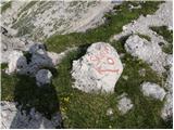 43
43 44
44 45
45 46
46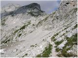 47
47 48
48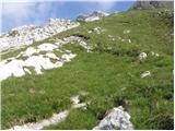 49
49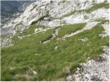 50
50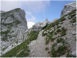 51
51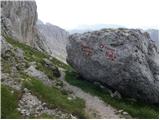 52
52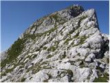 53
53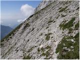 54
54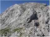 55
55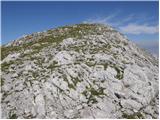 56
56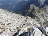 57
57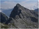 58
58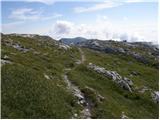 59
59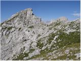 60
60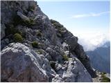 61
61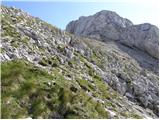 62
62 63
63 64
64 65
65 66
66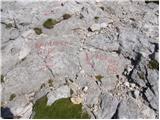 67
67 68
68 69
69
Discussion about the trail Planina Podvežak - Planjava (via Škarje)
|
| ločanka24. 07. 2016 |
Lepo pohajkovanje, pozoren moraš biti le, da najdeš pravo Lučko babo, da se ne veseliš prezgodaj. Obstoja več vrhov s skalnatimi piramidami na vrhu. Pot od škarij naprej skromno markirana, predvsem so le te zelo obledele, najbrž nazadnje obnovljene pred več desetletji.
|
|
|
|
| Gregor Celje27. 08. 2016 |
Med Škarjami in vrhom so markacije res povsem zbledele. Ne priporočam v megli ali dežju.
|
|
|