Planina Dol - Rzenik (east path)
Starting point: Planina Dol (1308 m)
| Lat/Lon: | 46,3178°N 14,6379°E |
| |
Name of path: east path
Time of walking: 1 h 40 min
Difficulty: easy unmarked way
Altitude difference: 525 m
Altitude difference po putu: 525 m
Map: Kamniške in Savinjske Alpe 1:50.000
Recommended equipment (summer):
Recommended equipment (winter): ice axe, crampons
Views: 12.138
 | 1 person likes this post |
Access to the starting point:
First, we drive to Kamnik, then we continue our drive towards the Črnivec Pass. Just 100 m before the pass, we see signs for Kranjski Rak, which direct us sharp left onto a narrow and initially quite steep road. The road is then higher and leads to the Volovjek Pass, where, just after the Kranjski Rak guesthouse, turn left onto the road in the route Velika planina. Continue along the dirt road, which leads you higher up to the next slightly larger crossroads. Continue to the right (straight ahead mountain pasture Kisovec) and follow the moderately ascending road past the Ušivec parking lot. From the parking lot continue along the slightly worse macadam road, which at the crossroads you follow in the route mountain pasture Dol. After a while the road starts to descend steeply, and we follow it to a marked parking lot near mountain pasture Dol.
From the Savinjska valley, we first drive to Luce, and then continue on towards Kamnik. When you reach the Volovjek (Kranjski Rak) pass, turn right in the route Velika planina. Continue following the above description.
Path description:
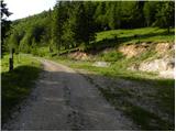
From the parking lot, continue along the dirt road, which descends only slightly towards the western part of mountain pasture. After a few minutes of easy walking, you will see a shepherd's hut on the left, and we continue along the dirt road for another 10 m, to a place where we see signs for Konja on a tree, which direct us to the right across the meadow (Velika planina on the left, straight ahead the valley of the Kamniška Bistrica - the lower station of the cable car to Velika planina). The trail continues on a moderate ascent across the meadow, then into the forest, where it turns right and gradually starts to climb steeper and steeper. There is a steep climb through the forest for about 20 minutes, and then the path leads to a small lookout point. Here the path turns left and also slightly slopes down. Continue along the moderately steep path, where you soon pass from the increasingly sparse forest into the dwarf pines zone. There is a short climb on a well-trodden path through dwarf pines and the path leads to mountain pasture Rzenik, at the edge of which a shepherd's hut can be seen.
From the hut, follow the marked trail towards Konjo (slightly left Rzenik on the western trail), which leads quickly between dwarf pines. The ascent continues on a moderately steep path, and we walk along it for only about 10 minutes, then we will notice a rather overgrown path on the left leading to Rzenik (the start of the unmarked path is difficult to find).
From the point where you leave the marked trail, first ascend through dwarf pines (overgrown), then continue through a raspberry belt, and higher up again through dwarf pines (a little less overgrown). After about 15 minutes on the overgrown trail, you will come to the ridge of Rzenik, which you should follow to the left. The trail continues along the edge of the occasionally exposed ridge, but unlike the initial part, it is much easier to follow, only in wet conditions more care is needed to avoid slipping on the steep grasses. Higher up, the path leads us past a mighty crevasse, and then, within a few minutes of further walking, leads us to the top of Rzenik.

Pictures:
 1
1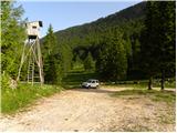 2
2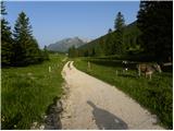 3
3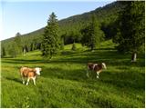 4
4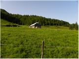 5
5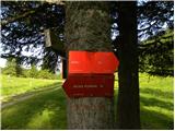 6
6 7
7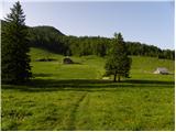 8
8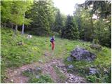 9
9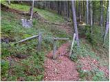 10
10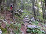 11
11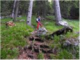 12
12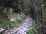 13
13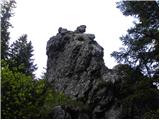 14
14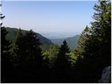 15
15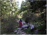 16
16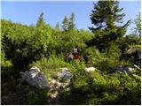 17
17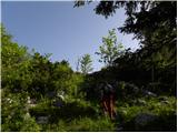 18
18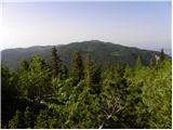 19
19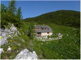 20
20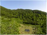 21
21 22
22 23
23 24
24 25
25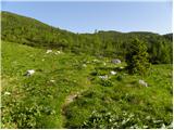 26
26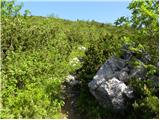 27
27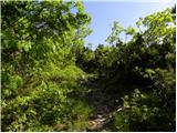 28
28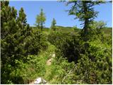 29
29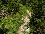 30
30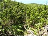 31
31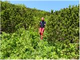 32
32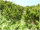 33
33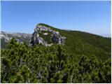 34
34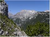 35
35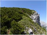 36
36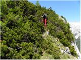 37
37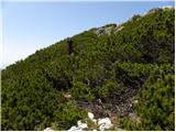 38
38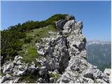 39
39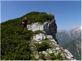 40
40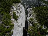 41
41 42
42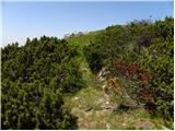 43
43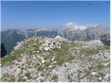 44
44
Discussion about the trail Planina Dol - Rzenik (east path)
|
| pohodnik386. 05. 2012 |
Zanimiva pot škoda da ni markirana in še nekaj slik izpred tedna dni ko sem bil gor. SLIKE
|
|
|
|
| rober6. 05. 2012 |
Hvala markacistom, da ni.kam pa pridemo, če bo vse markirano.: 
|
|
|
|
| pohodnik386. 05. 2012 |
Saj zarad mene tak ne jaz bom že prišel tam kamor bom hotel samo drugi se potem pritožujejo kako so se zgubili ali zašli pa kako je bilo težko gor pridet.
|
|
|
|
| Volk8. 05. 2012 |
Pohodnik38, saj je tudi čez Sfingo težko priti pa se nihče ne pritožuje. O tem, da je markiranih poti v naših gorah več kot dovolj pa je bilo tudi že govora.
Lp.
|
|
|
|
| Darxta18. 05. 2013 |
Danes po vzhodni gor, po zahodni dol. Pot na Rzenik je res težko najti. Jaz sem jo na poti na Konja popolnoma spregledal, na poti dol pa sem moral uporabiti GPS  Dodal bi pa, da kdor želi priti na Rzenik, naj tudi slučajno ne hodi v kratkih hlačah ali majici s kratkimi rokavi, razen če ga ni strah večjega števila prask  Tudi pohodne palice bi odsvetoval, ni prostora za uporabo. Namesto tega raje kakšne rokavice, za oprijemanje rušja na izpostavljenem grebenu. Razgled z vrha? Fenomenalen
|
|
|
|
| jax8. 06. 2014 |
Bil danes gor. V opisu manjka pomemben podatek - odcep poti na Rzenik je označen! Na macesnu na desni strani poti (v smeri vzpona - če prihajaš s Konja, pa seveda na levi) je kažipot. Res je dokaj visoko in utegne biti malo skrit med vejevjem, ampak če veš, da obstaja, ga boš gotovo videl.
Kar pa se poti tiče - orientacijskih težav sploh ni. Na odcepu je kažipot, potem pa je pot vselej vidna. Je pa res precej preraščena z ruševjem, tako da je naporna in mora človek pokazati kar precej srca, da pride skozi. Tehničnih težav ravno tako ni, je pa na poti kratek izpostavljen odsek po vrhu stene. Ampak če mene vprašate, se splača. Razgled je še malo lepši kot s Konja, rob stene pa tudi doda svoj čar. In ko vidiš množico na Konju, ti pa si tu gor sam, je mera polna.
|
|
|
|
| anak6. 10. 2018 |
Ob lepo izsekani stezi je bila še nedolgo nazaj
lesena tablica z napisom Rzenik. Danes je ni bilo več...
|
|
|
|
| anica.zu@gmail.com23. 10. 2019 |
Danes sem bila na Konju in na Rzeniku. Pot je lepo označena in krasno izsekana (ČESTITKE), tako da je dostop na vrh brez posebnosti, pravi užitek. Razgled z obeh vrhov pa enkraten.
|
|
|
|
| natasacraine23. 08. 2024 20:30:57 |
Kako je s parkiranjem na planini Dol? A se še da? Al je treba parkirati prej? Hvalaaa...
|
|
|