Oberissalm - Rinnenspitze (normal approach past Franz-Senn-Hütte)
Starting point: Oberissalm (1742 m)
| Lat/Lon: | 47,09572°N 11,19491°E |
| |
Name of path: normal approach past Franz-Senn-Hütte
Time of walking: 3 h 45 min
Difficulty: difficult marked way
Altitude difference: 1261 m
Altitude difference po putu: 1261 m
Map: Stubaier Alpen Mitte, 31/4 1:25.000; Outdooractive Stubai Wanderkarte
Recommended equipment (summer): helmet
Recommended equipment (winter): helmet, ice axe, crampons
Views: 814
 | 6 people like this post |
Access to the starting point:
From Ljubljana, take the motorway past Salzburg towards Munich. At the Dreieck Inntal multi-level junction, take the A93 towards Innsbruck/Kufstein/Brenner. On your return to Austria, continue to the Innsbruck-Mitte exit. Here, do not turn towards Innsbruck, but continue on the A13 motorway towards the Brenner Pass. Leave the motorway at exit 10-Schönberg and follow the comfortable road through the Stubai Valley to Neustift im Stubaital, where you take the first exit at the roundabout in the middle of the town and follow the ascending road to the village of Milders. In Milders, follow the Mühlenweg and the signs for Oberissalm. To get to mountain pasture, there are about 8 km of increasingly narrow asphalt road, which is often used by cattle, so you need to factor in any waiting for a crossing into your estimated driving time. At mountain pasture, Oberiss is parked in a parking lot with a parking fee of 5 euros per day.
An alternative is to drive through northern Itali: in this case, take the A2 motorway from central Slovenia to one of the border crossings with Austria and continue to Lienz. Here you continue on the 100 road and pass the Prato alla Drava crossing into Itali. In Itali, follow the SS49 all the way to the junction with the A22 motorway in the direction of the Brenner Pass. After the pass, continue in the direction of Innsbruck to the Schönberg exit. From there, follow the route described above.
Path description:
At mountain pasture, at the signpost above the parking lot, turn onto a wide dirt road, which, within a few minutes of mainly horizontal walking south-westwards, leads to a well-marked off-ramp of a narrow lane, which, with fine views of the eastern part of the Alpeine mountain range and the mountain pasture Oberiss below, leads you in a rather gentle curve through the sparse high mountain forest. A little higher up, we change to grassland with alpine alpine vegetation at the edge of the upper Obergbach valley, and the steepness gently subsides with fine views towards Franz Senn's hut and Vordere Sommerwand above it. Following a pleasant and scenic path in the last part of the way to the hut, you will pass the mountain pasture Alpeiner past a shepherd's hut and climb through an attractive watery landscape to the popular Franz-Senn-Hütte in just over 15 minutes; from the starting point it is about an hour and a half walk to the hut.
At the large signpost behind the small bridge next to the hut, follow the signs for Rinnenspitze and Rinnensee to the right (north-east) and follow the path winding across the grassy slope up to a short rocky passage above the torrent bed; the passage is secured by a couple of rocks, but in terrestrial conditions they only serve as an additional support. Shortly after the jump, the steepness eases a little and, with magnificent views of the Sommerwand ridge and the rest of the peaks in the Alpein mountain range, we climb leisurely for a while along a relatively wide path over grassy glades. Soon the tip of the trail's destination is revealed, and the trail begins to turn westwards. At the edge of the high mountain plateau hosting Rinnenspitze and Rinnensee, we come across a bench at a lookout point and head firmly to the right towards the summit building of Rinnenspitze. The grassy expanse gradually gives way to the rocky extension of the Rinnenspitze rock building, over which, following a path that more or less skilfully avoids the sharp edges of the rubble with its rather large boulders, we climb steeply to a crossroads below the Rinnenspitze summit structure. From here it is about 45 minutes' climb to the top, and a short walk to Lake Rinnensee (I recommend a visit to this attractive alpine lake on the ascent or descent).
In the final part of the ascent to Rinnenspitze, an increasingly steep path leads us over the broken boulders of the mountain, where it is necessary to help yourself with your hands in places. As we climb relatively quickly towards the ridge, which we can clearly see ahead of us, we get a good view of the lake below. After a half-hour's walk from the crossroads, signs lead us to the start of the protected path, which will take us from here right to the top.
At first, with the help of a rope ladder and a number of scrambles, we climb over quite steep flat rocks to the jagged summit ridge Rinnenspitze, where a rope ladder helps us over the most precarious spots. After a short crossing of a not particularly exposed ridge, with the help of a rope and pegs, we climb over a steep jump (a key point) and cross to the south side of the mountain just below the ridge. When you see the summit cross in front of you, the only way to reach the highest point of the trip is a final climb over the slightly crumbly summit slope of the mountain, made easier by wire ropes.
Although Rinnenspitze is not as easily accessible as some of the other Stubai Alps equivalents (e. g. Sulzkogel or Zischgeles), the route up it should not present too many obstacles for an experienced hillwalker in terrestrial conditions, and the beautiful view from the summit and the rather dynamic ascent route, which takes in a rather enticing mountain landscape, make the summit the perfect place to start exploring the highest parts of the Stubai Alps. This is also reflected in the number of visitors, as Rinnenspitze is one of the most visited mountains in the Alpeine mountain range, helped by its status as one of the 7 "classic peaks of the Stubai".

Pictures:
 1
1 2
2 3
3 4
4 5
5 6
6 7
7 8
8 9
9 10
10 11
11 12
12 13
13 14
14 15
15 16
16 17
17 18
18 19
19 20
20 21
21 22
22 23
23 24
24 25
25 26
26 27
27 28
28 29
29 30
30 31
31 32
32 33
33 34
34 35
35 36
36 37
37 38
38 39
39 40
40 41
41 42
42 43
43 44
44 45
45 46
46 47
47 48
48 49
49 50
50 51
51 52
52 53
53 54
54 55
55 56
56 57
57 58
58 59
59 60
60 61
61 62
62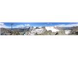 63
63
Discussion about the trail Oberissalm - Rinnenspitze (normal approach past Franz-Senn-Hütte)