Mönichkirchen - Hochwechsel (via Studentenkreuz)
Starting point: Mönichkirchen (1006 m)
| Lat/Lon: | 47,51217°N 16,03173°E |
| |
Name of path: via Studentenkreuz
Time of walking: 3 h 45 min
Difficulty: easy marked way
Altitude difference: 737 m
Altitude difference po putu: 800 m
Map:
Recommended equipment (summer):
Recommended equipment (winter): ice axe, crampons
Views: 112
 | 1 person likes this post |
Access to the starting point:
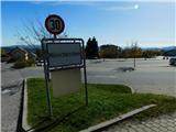
Exit the A2 motorway Graz / Graz - Vienna / Wien at the Pinggau, Friedberg exit, then take the exit from the nearby roundabout in the direction of the above-mentioned towns, Vienna and Graz. A few kilometres further on, at the junction of the regional roads, follow the signs for Vienna and Mönichkirchen. Continue along Wechsel Straße, leaving the mainly ascending road at the exit for Mönichkirchen. Then drive through the village to a large parking lot above the village, located at the foot of the ski slope.
Path description:
On the right, east side of the parking lot, the asphalt road continues, with a few more car parks alongside, and we follow it up by the ski slope. After a few minutes, we reach a marked crossroads where the path to Mönichkirchner-Schwaig splits into two.
Continue slightly left in the direction of the Studentenkreuz crossing and continue across the ski slope (with caution, as you are crossing the route of a slope used for downhill runs in the summer season). Continue under the chairlift, and when the road turns left, go straight onto the marked footpath, which quickly splits in the woods. At the fork by the hunting observatory, go left again, in the direction of the cross mentioned earlier. There is a slightly steeper climb through the forest for a few minutes, and after crossing the grassy cart track, the path gradually flattens out. Continue climbing through the woods, and at the aforementioned crossroads you reach a dirt road, which you follow to the left in the direction of Vorauer Schwaig and Hallerhaus (to the right Mönichkirchner-Schwaig). The path continues along a gently sloping dirt road, and at a marked crossroads you go straight ahead, continuing in the direction of Vorauer Schwaig and Hallerhaus.
At the next marked crossroads, leave the road and continue slightly left in the direction of Vorauer Schwaig (straight ahead to Hallerhaus). Continue gently through the woods, passing a small signpost, and a little further on reach cart track, which is followed to the left, quickly reaching a dirt road, which continues a short distance up a slight incline. From the road, bear slightly right and continue climbing moderately. At a higher level, cross the wider cart track (Hallerhaus on the right) and continue ascending cross-country. A little further on, cross a gravel road and quickly leave it. Cross the road again a little further on, and continue on higher ground. A few minutes further on, go slightly left off the road and we continue to climb cross-country, this time through increasingly sparse forest. When we leave the forest, we quickly reach the Vorauer Schwaig hut by following the cart track, or back road.
At Vorauer Schwaig, some paths join from the left, and a path to Niederwechsel branches off to the right, and we continue straight on to Hochwechsel, where we pass a military cemetery on the left. There is a longer traverse along cart track, which continues with some short ascents and descents, most of the time with beautiful views of the surrounding hills. Later, the path branches slightly to the left towards the Kaltwiesenhütte and Rablkreuz Hütte huts, and we continue slightly to the right, where we gradually start to climb more visibly. There is some cross-climbing, and at 1647 m we reach a crossroads where we join the path leading over the Niederwechsel summit.
Continue straight ahead (sharp right Niederwechsel) and start climbing, first gently and then moderately. Follow this path to the Wetterkoglerhaus am Hochwechsel hut, where you join the road. Cross the road at the start of the car park and walk to the summit a few steps away.
Starting point - Vorauer Schwaig 2:30, Vorauer Schwaig - Hochwechsel 1:15.
Description and pictures refer to the situation in October 2022.

Pictures:
 1
1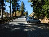 2
2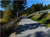 3
3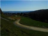 4
4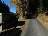 5
5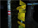 6
6 7
7 8
8 9
9 10
10 11
11 12
12 13
13 14
14 15
15 16
16 17
17 18
18 19
19 20
20 21
21 22
22 23
23 24
24 25
25 26
26 27
27 28
28 29
29 30
30 31
31 32
32 33
33 34
34 35
35 36
36 37
37 38
38 39
39 40
40 41
41 42
42 43
43 44
44 45
45 46
46 47
47 48
48 49
49 50
50 51
51 52
52 53
53 54
54 55
55 56
56 57
57 58
58 59
59 60
60 61
61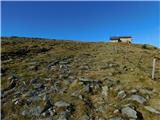 62
62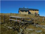 63
63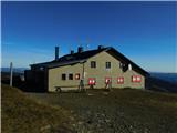 64
64 65
65 66
66 67
67
Discussion about the trail Mönichkirchen - Hochwechsel (via Studentenkreuz)