Maria Waldrast - Lämpermahdspitze (Path over the northern ridge)
Starting point: Maria Waldrast (1638 m)
| Lat/Lon: | 47,13159°N 11,40445°E |
| |
Name of path: Path over the northern ridge
Time of walking: 3 h 15 min
Difficulty: very difficult marked way
Altitude difference: 957 m
Altitude difference po putu: 957 m
Map: Innsbruck und Umgebung, 31/5 1:50.000; Outdooractive Stubai Wanderkarte
Recommended equipment (summer): helmet
Recommended equipment (winter): helmet, ice axe, crampons
Views: 367
 | 2 people like this post |
Access to the starting point:
From Ljubljana, take the motorway past Salzburg towards Munich. At the Dreieck Inntal multi-level junction, take the A93 towards Innsbruck/Kufstein/Brenner. On your return to Austria, continue to the Innsbruck-Mitte exit. Here, do not turn towards Innsbruck, but continue on the A13 motorway towards the Brenner Pass. Continue on the motorway until Matrei am Brenner, where you take exit 19-Matrei. Then take the B182 and follow it to the village of Mützens, where, with the help of reliable signs, you will find a narrower road which, after crossing a barrier (the toll is €6 for a car), will lead you within a few kilometres to a parking area near the inn and the monastery church.
The alternative is to drive through northern Itali: in this case, from central Slovenia, take the A2 motorway to one of the border crossings with Austria and continue to Lienz. Here you continue on the 100 road and pass the Prato alla Drava crossing into Itali. In Itali, follow the SS49 all the way to the junction with the A22 motorway in the direction of the Brenner Pass. After the pass, continue in the direction of Innsbruck to exit 19-Matrei at Matrei am Brenner. From there, continue along the route described above.
Path description:
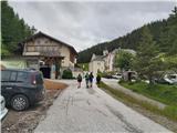
From the parking lot of Maria Waldrast, the highest pilgrimage station in Austria, follow the signs for Serles and LämpermahdspitzeXX along the path which turns left into the forest immediately after the church. Passing through grazing areas, follow the path which soon crosses a scree ravine in the eastern wall of Serlesa. Further on, the well-marked path leads us through increasingly sparse high mountain forest, which is replaced by dwarf pines higher up, and twice more we cross the outcrops of steep ravines that emerge from the rocky slopes above us. After a good hour's walk from the starting point, we reach the open grassy slopes in the heart of the Serles group, with a fine view of the southern part of the mountain range, where Lämpermahdspitze and Peilspitze are in the ascendancy. The trail, which crosses a moderately steep slope in a series of switchbacks, is followed as far as the Serlesjöchl Pass, where the Marie Waldrast trail joins the longer alternative approach trail from Kampl in the Stubai Valley.
From the saddle, use the signpost to turn left onto the initially slightly less visible path that crosses the slope below the steep cliffs of the Rota Wanda (an easier path that crosses under the peaks of the southern part of the Serles group and offers an alternative option to return to Marie Waldrast, only a few metres lower at the start of the ascent from the pass). After crossing under a large abyss in the wall of the Rota Wanda, the path crosses a scree slope on the edge of which the snow often stays until the end of the summer. Then climb a steep, but not too difficult, rock step and follow the typical Austrian markings in the switchbacks to an unnamed grassy ridge top, from where the continuation of the ridge route to Lämpermahdspitze is revealed.
Here, follow the signs which reliably lead directly along or just below the exposed ridge on its western side. In a few places we have to climb more easily (I), but otherwise the route is elegantly laid out and excellently marked over difficult terrain. After about 15 minutes, pass under the Lämpermahdspitze summit building, follow the signs, cross an exposed part of the ridge cut and head right onto the western slopes of the mountain. The crossing continues over large scree slopes that drop deep into the Stubai valley, but the otherwise still well-marked path is in places quite crumbly and slightly exposed. Soon the route turns towards the summit ridge Lämpermahdspitze, which is reached by a relatively rough chimney with the only fixed safety gear on the way. Behind it, below the Lämpermahdspitze headland, we approach a slightly broader ridge which leads us comfortably in a few minutes to a viewpoint summit with a metal cross.
With the exception of the marginally useful step in chimney, the whole route is unprotected and in places quite exposed, so despite the relatively low technical obstacles (climbing difficulty up to maximum I+) and the short length of the ascent from Serlesjöchl, it requires adequate mountaineering experience and reliable weather conditions. The ascent is usually combined with the approach to the famous Serles, as both mountains are accessible from the Serlesjöchl Pass within an hour's walk. Lämpermahdspitze can also be ascended by an easier route, which leads to the summit from the south.

Pictures:
 1
1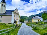 2
2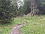 3
3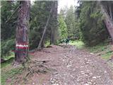 4
4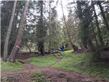 5
5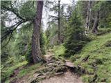 6
6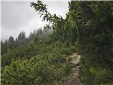 7
7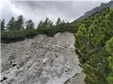 8
8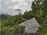 9
9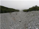 10
10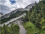 11
11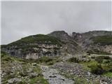 12
12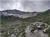 13
13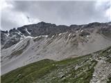 14
14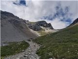 15
15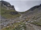 16
16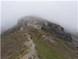 17
17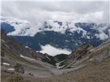 18
18 19
19 20
20 21
21 22
22 23
23 24
24 25
25 26
26 27
27 28
28 29
29 30
30 31
31 32
32 33
33 34
34 35
35 36
36 37
37 38
38 39
39 40
40 41
41 42
42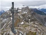 43
43
Discussion about the trail Maria Waldrast - Lämpermahdspitze (Path over the northern ridge)