Ljubelj - Srednji vrh (above Završnica) (on the slope of Vrtača)
Starting point: Ljubelj (1058 m)
| Lat/Lon: | 46,4324°N 14,2602°E |
| |
Name of path: on the slope of Vrtača
Time of walking: 3 h
Difficulty: easy marked way
Altitude difference: 738 m
Altitude difference po putu: 738 m
Map: Stol in Begunjščica, 1 : 25.000, PZS
Recommended equipment (summer):
Recommended equipment (winter):
Views: 10.361
 | 1 person likes this post |
Access to the starting point:
Drive to the Ljubelj border crossing and just before the crossing turn left into the large parking lot under the chairlift to Zelenica.
Path description:
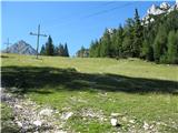
Take one of the paths (marked mountain trail, service road or border track) up to the house at Zelenica.
From the house, go uphill for a few dozen metres on the path leading to the hut at the source of the Završnice River, then turn right onto a barely visible path that crosses a meadow (ski slope) and disappears into the wods on the opposite side. There is no signpost on the trail, but you will see the signpost just before you turn into the copse. This trail leads to Vertatscha (and Hochstuhl) and follows the slope of Vertatscha all the way, initially in a sparse copse, then through dwarf pines and over scree, climbing moderately and with a very good view.
When you come to a fork marked on a stone on the path, pointing right to Vertatscha, left to Hochstuhl, take the path to the left leading to Hochstuhl. From this fork onwards, the path is practically unmarked, but clearly visible and well worn. This path, mostly through dwarf pines, at first almost horizontally, and in the last part in a slight descent, leads us to the Šija saddle (the saddle between Vertatscha and Sredni vrh). Here there is a pillar with old wooden direction signs pointing the way in the direction of Vertatscha and Hochstuhla.
At the saddle, take the path that leads left up to Srednji vrh (beware - there is another path, seemingly more steep, but oriented along the slope downwards). The path is wide for the first few metres, but very quickly narrows sharply and remains so for most of the way. It follows the edge of the slope, a small part of it at a moderate gradient and most of it at a fairly steep gradient. The path is easy to follow, but so narrow that in many places we are pushing tall grasses and low bushes away with our feet as we walk. Part of the path is covered with fine sand, and care is needed on the steep parts to avoid slipping.
In less than half an hour from the saddle, we reach a not very spacious summit with a signing-in book but no stamp. The route is rewarded with wonderful views of the valley and the neighbouring peaks - Vertatscha, Hochstuhl, Begunjščica, and of course also those more distant, both in Karawanks, as well as in the Julian and Kamnik Alps.
We can return along the same route, or from the Šija saddle we can head down towards Zelenica or Smokuška planina (the hut at the source of the Završnice river). In the latter case, we will first have a considerable descent to mountain pasture, and then a considerable climb up to Zelenica.

Pictures:
 1
1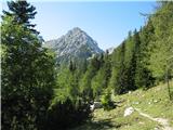 2
2 3
3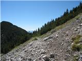 4
4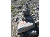 5
5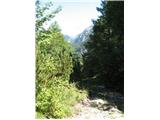 6
6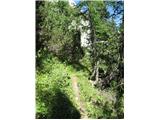 7
7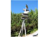 8
8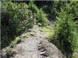 9
9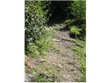 10
10 11
11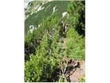 12
12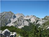 13
13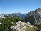 14
14 15
15
Discussion about the trail Ljubelj - Srednji vrh (above Završnica) (on the slope of Vrtača)
|
| Kokta22. 09. 2014 |
Pot od sedla Šija do vrha je markirana.
|
|
|
|
| ločanka26. 08. 2019 |
Na vrhu lahko naletite na gade. Včeraj sta bila kar dva, eden cca 2 m od križa proti vzhodu (ravno tam, kjer je primerno mesto za slikanje koče pri Završnici), drugi pa proti nasprotnemu vrhu (požagane veje). Oba sta se hitro umaknila, a drugi je pozabil potegniti rep za sabo, tako da sem le-tega lahko poslikala.
|
|
|
|
| turbo27. 08. 2019 |
ločanka, ne me strašit. Sem v prvo na hitro prebral in si rekel: "Kaj takega, 2m (dva metra) dolgega gada je srečala  Potem sem prebral še enkrat in si oddahnil 
|
|
|
|
| anica.zu@gmail.com27. 08. 2019 |
Tudi jaz sem ga vidla na poti od Šije proti Srednjemu vrhu.
|
|
|
|
| ločanka27. 08. 2019 |
turbo, samo menda je bil pa prav gor res viden en primerek dolg 1 m
|
|
|
|
| sla27. 08. 2019 |
Jaz sem ga videla enako kot ločanka vzhodno od križa (slab meterček je imel  ). Očitno je tam doma, torej ga pustimo lepo pri miru. Ko sem namreč odhajala z vrha, je bil spet na isti lokaciji, tam se je sončil
|
|
|