Kühtai - Sulzkogel (normal approach from Kühtai)
Starting point: Kühtai (2020 m)
| Lat/Lon: | 47,21371°N 11,02469°E |
| |
Name of path: normal approach from Kühtai
Time of walking: 3 h 30 min
Difficulty: easy marked way
Altitude difference: 996 m
Altitude difference po putu: 996 m
Map: Stubaier Alpen Sellrain, 31/2 1:25.000
Recommended equipment (summer):
Recommended equipment (winter): ice axe, crampons
Views: 1.460
 | 5 people like this post |
Access to the starting point:
From Ljubljana, take the motorway past Salzburg towards Munich. At the Dreieck Inntal multi-level junction, take the A93 towards Innsbruck/Kufstein/Brenner. On your return to Austria, continue on the A12 motorway to the junction with exit 87-Zirl-Ost. There, join the L13 and follow it into the Sellraine valley. The wide and comfortable road continues past Sellrain, Gries and St. Sigmund and through a long tunnel, after which, after about 20 km of moderate climbing, we find ourselves in the tourist hamlet of Kühtai. The best parking is free of charge at the chapel and bus stop just after the signpost marking the start of the village, but as long as it is busy, the hamlet offers a number of alternatives. It is also possible to drive through the village and start the climb at the Dortmunder Hütte, in which case there is a slightly higher altitude difference but a slightly more direct route to the Finstertal reservoir.
An alternative is to drive through northern Itali: in this case, from central Slovenia, take the A2 motorway to one of the border crossings with Austria and continue to Lienz. Here you continue on the 100 road and pass the Prato alla Drava crossing into Itali. In Itali, follow the SS49 all the way to the junction with the A22 motorway in the direction of the Brenner Pass. After the pass, continue in the direction of Innsbruck and then a few kilometres in the direction of Bregenz to exit 87-Zirl-Ost. From there, follow the directions given above.
Path description:
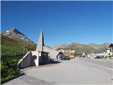
Just above the high mountain chapel in the eastern part of Kühtai, a signpost points west towards Sulzkogl and the Finstertal reservoir. After a few minutes of easy crossing above Kühtai, the trail turns south and begins to descend gently towards a plain about 50 metres below the starting point, from which you can see the continuation of the trail towards the viewpoint above the lake, located to the left of the barrier above us. The path, which is soon joined by the path coming from the route of the Dortmunder Hütte, continues for some time on a moderate ascent up a grassy slope, crossing torrents on several occasions. A little higher up, we cross the mountain road a few times and, after a good hour's walk from the starting point above the tunnel, we climb up to a lookout point above the northern edge of the reservoir, where there is a large panoramic signboard and a fine view of the Zwölferkogel massif, which obscures the Sulzkogel behind it.
The path continues along a mainly horizontal slope to the left above the lake (or rather above the depression in which it was located) and, after a leisurely walk of just over half an hour, leads to the southern edge of the lake, below the rock building of the Finstertaler Schartenkopf (Finstertaler Schartenkopf). At the end of the crossing above the lake, at the signpost, continue straight on in a south-westerly direction (a sharp left - eastwards - forks the path towards Finstertaler Schart).
From the crossroads onwards, the trail begins to climb moderately, initially crossing a major stream, but shortly afterwards climbing a steep slope, which is snow-covered for most of the year, it ascends somewhat more noticeably to the vast, rugged valley below the Sulzkogel and Gamskogl massifs, which is usually still snow-covered in the first half of July, but which, due to the undemanding nature of the terrain and the relatively gentle terrain, does not usually cause too many problems. After about half an hour of relatively gentle walking along a path that runs along the right edge of the plain, signs direct you up towards the ridge on a slightly crumbly slope.
At a small saddle below the Sulzkogla rock formation, turn right and follow the path, which runs along the rubble of the sometimes hefty rocks of the broad summit ridge, in switchbacks to a fairly spacious and very scenic summit.
Tura zaradi tehnične nezahtevnosti in razmeroma majhne višinske razlike po poti ter zaznavne kvalitete panorame z vrha ponuja mikavno priložnost za lagoden pristop na tritisočak, vendar se je vzponu v poletni vročini zaradi soncu izpostavljene lege in gruščnatega terena smiselno izogniti.

Pictures:
 1
1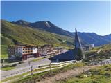 2
2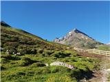 3
3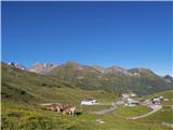 4
4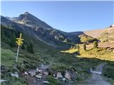 5
5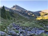 6
6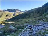 7
7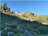 8
8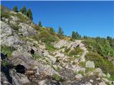 9
9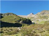 10
10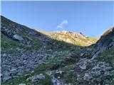 11
11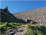 12
12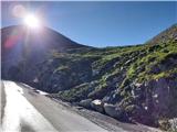 13
13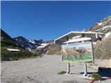 14
14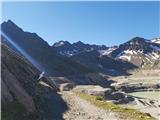 15
15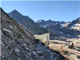 16
16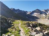 17
17 18
18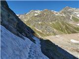 19
19 20
20 21
21 22
22 23
23 24
24 25
25 26
26 27
27 28
28 29
29 30
30 31
31 32
32 33
33 34
34 35
35 36
36 37
37 38
38 39
39 40
40 41
41 42
42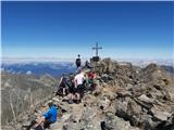 43
43
Discussion about the trail Kühtai - Sulzkogel (normal approach from Kühtai)