Kriška planina - Planina Košutna
Starting point: Kriška planina (1480 m)
| Lat/Lon: | 46,2929°N 14,5369°E |
| |
Time of walking: 1 h 35 min
Difficulty: partly demanding marked way
Altitude difference: 298 m
Altitude difference po putu: 400 m
Map: Kamniške in Savinjske Alpe 1:50.000
Recommended equipment (summer): helmet
Recommended equipment (winter): helmet, ice axe, crampons
Views: 38.653
 | 3 people like this post |
Access to the starting point:
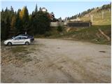
a) From the motorway Ljubljana - Jesenice take the exit Vodice, then continue to the first semaphore crossing in Vodice, where you turn left towards Cerkelj na Gorenjskem and Brnik. When you reach the main roundabout at Spodnji Brnik, continue driving in the direction of Cerkeliai and the ski resort Krvavec. At the end of Cerklje na Gorenjskem, leave the main road, which continues towards Velesovo and Visoke, and turn slightly right onto the road towards the ski resort Krvavec. Continue to the village of Grad, where signs for Ambrož pod Krvavcem direct you to the right on a steep asphalt road (straight ahead to the lower station of the round-cabin cable car to Krvavec and Štefanja Gora). When the steepness of the steep road eases slightly, you will come to a junction, where you will continue to the left in the direction of Ambrož pod Krvavcem (straight ahead to the settlements of Ravne, Apno and Šenturška Gora). A little further on, the road descends a little, then climbs over slopes that are sometimes quite scenic. Higher up, you reach Ambrož pod Krvavcem, where you pass the church of St Ambrose and the tourist farm Pr Ambružarju on the left. From the tourist farm the road passes into the forest and climbs through it to mountain pasture Jezerec, where there is a large parking lot. The road is laid here and turns left, about 500 m further on it leads to a crossroads, where you continue right in the direction of Kriška planina (straight ahead the upper station of the round-cabin cableway and the Mountain Home at Gospinac). There is only a short steep climb and you arrive at a parking lot at the edge of Kriška planina.
The road from mountain pasture Jezerec to Kriška planina is now closed to public traffic, which extends the journey by about 15 minutes.
b) From the motorway Jesenice - Ljubljana take the exit Kranj - East, then continue to Brnik, Komenda and Mengeš. Once you reach the main roundabout at Spodnji Brnik, continue driving towards Cerkeliai and the ski resort Krvavec. At the end of Cerklje na Gorenjskem, leave the main road, which continues towards Velesovo and Visoke, and turn slightly right onto the road towards the ski resort Krvavec. Continue to the village of Grad, where the signs for Ambrož pod Krvavcem direct you to the right on a steep asphalt road (straight ahead to the lower station of the circular cable car to Krvavec and Štefanja Gora). When the steepness of the steep road eases slightly, you will come to a crossroads, where you will continue to the left in the direction of Ambrož pod Krvavcem (straight ahead to the settlements of Ravne, Apno and Šenturška Gora). A little further on, the road descends a little, then climbs over slopes that are sometimes quite scenic. Higher up, you reach Ambrož pod Krvavcem, where you pass the church of St Ambrose and the tourist farm Pr Ambružarju on the left. From the tourist farm the road passes into the forest and climbs through it to mountain pasture Jezerec, where there is a large parking lot. The road is laid here and turns left, about 500 m further on it leads to a crossroads, where you continue right in the direction of Kriška planina (straight ahead the upper station of the round-cabin cableway and the Mountain Home at Gospinec). There is only a short steep climb and you arrive at a parking area at the edge of Kriška planina. Po novem je cesta od mountain pasture Jezerca do Kriška planina zaprta za javni promet, to nam pot podaljša za približno 15 minut.
Path description:
From the parking lot, turn onto the road in the route mountain pasture Koren. The road then leads through an underpass to a quarry, where you leave. Continue the ascent along a pleasant but poorly visible mountain path, which runs along the edge of the pasture fence. The path, which becomes more visible, then leaves the Kriška planina grazing areas and enters a world covered with dwarf pines. After a short climb, the path leads to a beautiful viewpoint, from which we have a beautiful view of the Korošica valley. Next, the path starts to descend more steeply and after a few minutes we are already 60m lower. The path then flattens out and we are joined on the right by the path from the valley mentioned above. Next we cross the lane of a forest, and then the path starts to climb again. During the ascent, an unmarked path branches off to the left, leading to the Razor saddle, and we continue on the marked path, which after a few minutes leads us to the southern part of the mountain pasture Koren. The path then descends past the animal watering point to the shepherd's hut at mountain pasture.
Here, at the hut, a path branches off slightly to the right (south-easterly direction) and leads to mountain pasture Košutna. The path initially crosses the slopes almost horizontally and then leads to a technically difficult place. The path climbs steeply over a short rock jump, where fixed safety gear is helpful. The path then lays down and leads us past a cross to mountain pasture Košutna, where a chapel and shepherd's hut stand.
Kriška planina - mountain pasture Koren 1:15, mountain pasture Koren - mountain pasture Košutna 20 minutes.

Pictures:
 1
1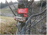 2
2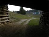 3
3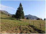 4
4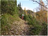 5
5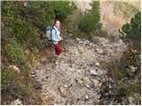 6
6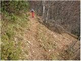 7
7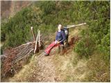 8
8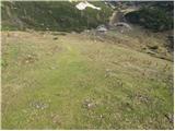 9
9 10
10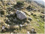 11
11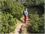 12
12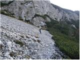 13
13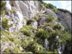 14
14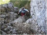 15
15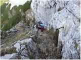 16
16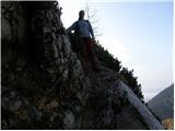 17
17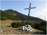 18
18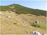 19
19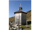 20
20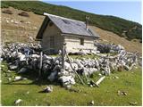 21
21
Discussion about the trail Kriška planina - Planina Košutna
|
| Guest20. 08. 2006 |
Prelep izlet še posebno v jesenskem času.Pozimi se pa izogneš gužvi na Krvavcu.
|
|
|
|
| Guest7. 09. 2007 |
Koliko zahtevno je tehnično zahtevno mesto, ali bi bilo še vedno primerno za 6 letne otroke?
|
|
|
|
| Guest7. 09. 2007 |
Če so že nekoliko navajeni vzpenjanja po skalah, bi šlo, ne smejo pa imeti strahu pred strmino pred seboj in globino pod sabo. Ta del poti ni dolg, meni se ne zdi izpostavljen, je pa kar pokonci postavljen, skalnat, treba je uporabiti roke.
Nekateri baje vlačijo 6-letnike celo po zelo zahtevni in izpostavljeni poti na Mangart, tako da najbrž 6-letniku teh nekaj metrov z malo pomoči ne bi smelo delati težav.
|
|
|
|
| kanjavec2. 12. 2008 |
Izlet zelo lepo opisan kot tudi slikovno prikazana pot.Večkrat sem že sam prehodil omenjeno pot tako gor kot tudi dol.Pot za mlajše planince pa toplo priporočam samo v letnem obdobju.
|
|
|
|
| jprim2. 12. 2008 |
Na tem koncu, ki sem ga prehodila pred 14 dnevi, je potrebno obnoviti vsaj napise, če že ne vseh markacij, saj na skalah se preprosto ne da nič prebrati, razen ugibati, no, če ti pot ni nova, potem veš kako, drugače pa greš malo iz prave poti ... in tako se znajdeš kje drugje.
LP
|
|
|
|
| pohodnica5326. 03. 2009 |
pot je čudovito prikazana, tako, da človeka kar potegne; zaradi vrtoglavice me zanima, ni možno nikakor obiti tega "tehnično zahtevnega dela"; ali gre samo za zelo strm vzpon (koliko m), ali pa je od strani slučajno tudi kaj prepadnega  , itak bi šla šele, ko ne bo več snega; hvala za informacije
|
|
|
|
| Biser gora27. 03. 2009 |
Gre za strmo, dobro zavarovano pot, ki se konča s kratko in rahlo izpostavljeno polico.
Omenjeni del se, da tudi obhoditi, če s planine Koren nadaljuješ proti Kompoteli in višje zaviješ desno v smeri Košutne.
|
|
|
|
| pohodnica5327. 03. 2009 |
hvala, za nasvet; da me ne bo panika, bom raje uporabila kar drugo varianto proti Kompoteli in če prav razumem, bom prav tako prišla do cilja planine Košutna; res je super tale portal in prijazni hribolazci; sedaj me ne skrbi več toliko, da bi kam zabredla zaradi strahu pred  prepadi, ker prej dobim takole informacije; sicer pa zelooo uživam v hribih;  res še enkrat hvala in prijeten pohodniški vikend želim vsem, ki pridno listajo, pišejo in objavljajo slike na hribih.net
|
|
|
|
| jprim29. 03. 2009 |
No, če ubereš smer proti Kompoteli,potem je tako bolje če nadaljuje na Kompotelo, saj pot ni zahtevna in še lepši razgledi so. Sama sem preko Košutne nadaljevala na Kompotelo.
LP!
|
|
|
|
| jprim29. 03. 2009 |
Pozabila sem dodati, da je bilo izhodišče drugje, in sicer na Markovi ravni.
|
|
|
|
| pohodnica5330. 03. 2009 |
Hvala obema za informacije  ; upam, da bo kmalu lepo vreme in da se bomo lahko podali na kak pohod; Lp
|
|
|
|
| pohodnica5315. 07. 2009 |
preprosto rečeno - prečudovita pot! Res raj v malem; startali na Kriški planini, nato na planino Koren, pa na planino Košutna (jupi, strah sem premagala in šla preko "zajl in klinov" - kako krasen občutek - in Heinz hvala za tovrstne vzpodbude), nato na vrh Košutne - malo smo se lovili po ruševju, ker ni nobenih oznak - nato na Kompotelo in krožno nazaj; resnično prekrasni razgledi - toplo priporočam vsem, ki vas še ni zanesel korak v ta planinski raj! - slikice drugič - fotograf je ostal doma
|
|
|