Koča pri Savici - Planina Viševnik
Starting point: Koča pri Savici (653 m)
| Lat/Lon: | 46,2896°N 13,8022°E |
| |
Time of walking: 3 h 10 min
Difficulty: difficult marked way
Altitude difference: 972 m
Altitude difference po putu: 985 m
Map: Triglav 1:25.000
Recommended equipment (summer): helmet
Recommended equipment (winter): helmet, ice axe, crampons
Views: 11.881
 | 1 person likes this post |
Access to the starting point:
From the motorway Ljubljana - Jesenica, take the Lesce exit and follow the road towards Bled and on to Bohinjska Bistrica. Continue driving towards Bohinjsko jezero (Ribčev laz), at which you will come to a crossroads, where you will continue straight along the left (south) side of the lake in the direction of Ukanec and the Savica waterfall. Follow this increasingly narrow road to the large parking lot at the Savica cottage. There is a charge for parking.
Path description:
From the parking lot, turn right in the direction of Črno jezero, Koča pri Triglavskih jezerih and Hotel Zlatorog. The route initially leads along a dirt road, which crosses the Savica River via a bridge. Just after the bridge, the signs for Komarčo direct us left (straight ahead Hotel Zlatorog) onto what is at first still a fairly wide and relatively winding forest path. However, the path soon starts to climb steeply and leads us a little higher to a place where the path to the spring Savica branches off to the left, and we continue to the right on an increasingly steep path.
The well-maintained and relatively wide mountain trail, however, soon switches to the very steep and dangerous for slipping slopes of Komarče (there is also a high risk of falling rocks). The way forward climbs steeply on the mostly forested wall of Komarče, where we are helped in the more difficult places by the fixed safety gear (mainly by jeklenice).
Higher up, we get some views of Bohinj from the path, and the path leads us to a short technically difficult place where we cross an otherwise not-so-exposed gully with the help of crampons and a rope. The way forward is still steeply climbing for some time and with the help of some fixed safety gear leads us to the top of Komarče, from where we get a nice view of our starting point. There is a short moderately steep climb, and then the path begins to descend gently towards Črno jezero, which is reached after less than 5 minutes of further walking.
A few steps before the lake, the marked trail turns right and quickly leads to a crossroads, where we continue to the right in the direction of mountain pasture Viševnik and Pršivec (directly to the cottage at the Triglav Lakes). The trail continues for some time through the dense forest, then crosses a short scenic slope and then returns to the forest. Here, on the right-hand side, a few tens of metres below the path, you will hear an interesting karst spring, which descends immediately after the spring via Komarča. (If you have the time and inclination, you can descend to the spring, but be careful as the spring ends with steep precipitous slopes).
The path, which passes through a little-visited area called Dol pod Stadorjem, flattens out for a short time and leads to a small valley, at the bottom of which the cold air often lingers. The path, which is often quite wet, continues into the forest, where it begins to climb steeply. A very quiet path emerges from the forest just before mountain pasture Viševnik, which is only a 5-minute easy walk away.

We can extend the trip to the following destinations: Planina Blato,
Dom na Komni,
Planina Lopučnica,
Planina Dedno Polje,
Planina Ovčarija,
Koča pri Triglavskih jezerih,
Pršivec ( 45 min),
Mala Tičarica,
Slatna,
Velika Tičarica,
Kopica,
Čelo
Pictures:
 1
1 2
2 3
3 4
4 5
5 6
6 7
7 8
8 9
9 10
10 11
11 12
12 13
13 14
14 15
15 16
16 17
17 18
18 19
19 20
20 21
21 22
22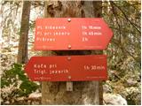 23
23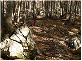 24
24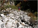 25
25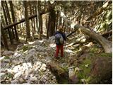 26
26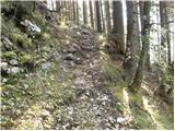 27
27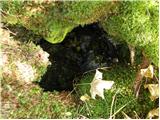 28
28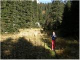 29
29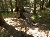 30
30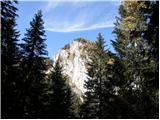 31
31 32
32 33
33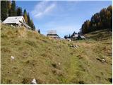 34
34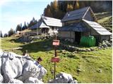 35
35
Discussion about the trail Koča pri Savici - Planina Viševnik
|
| MojcaH11. 07. 2009 |
Prejšnji teden sem šla iz Savice čez Komarčo do Črnega jezera in naprej po poti proti planini Viševnik.Pot je lepo šla do razgledne točke kjer je bila še vidna markacija.Ko sem prišla čez to melišče pa naprej čez izvir ni bilo nobene markacije več,ampak je bila pot še vedno lepo shojena.Potekala je nad robom in zavila desno čez manjši ror in potem se je med mladimi smrekami izgubila.
Zanima me ali je pot vseskozi markirana ali ne.
hvala za odgovor
lp
|
|
|
|
| Tadej11. 07. 2009 |
Pot je v celoti markirana in lepo prehodna.
|
|
|
|
| Daaam13. 09. 2010 |
Včeraj šel po tej poti. Pot je bila pred izvirom/slapom (cca 20 min. od črnega jezera naprej) res dvoumno speljana tako da sva se tudi midva in kasneje še trije planinci izgubili. Namesto da bi zavili bolj v levo po slabo vidni poti smo šli naravnost po dobro vidni lovski stezici naprej mimo slapa in dalje po robu stene v smeri Pršivca. Z malo truda in avanture  smo kasneje vendarle našli pravo pot. Ker smo kasneje slišali da nismo bili prvi ta dan ki smo "zajebal" križišče sem si na poti nazaj vzel par minut časa in to lovsko stezo malo zagradil z kamenjem  Še zmeraj se da čez če kdo hoče in pozna pot, tistim, ki pa se mislijo držati markirane poti pa upam da jim bo ovira pomagala da bodo zavili bolj v desno. Sem pa po povratku ugotovil da mi je nemarkirana ljubša (lepša in lepši razgledi) tako da ob naslednji priliki sigurno preskočim kamenje 
|
|
|
|
| Daaam13. 09. 2010 |
Še zmeraj se da čez če kdo hoče in pozna pot, tistim, ki pa se mislijo držati markirane poti pa upam da jim bo ovira pomagala da bodo zavili bolj v desno. Se opravičujem -bolj v levo. je pravilno
|
|
|
|
| pojoča travica13. 07. 2015 |
Včeraj sem šla po markirani poti. Pot je lepo označena, izredno mirna, prijetna.
|
|
|