Globasnica / Globasnitz - Gora sv. Eme (Junska gora) / Hemmaberg
Starting point: Globasnica / Globasnitz (541 m)
| Lat/Lon: | 46,5572°N 14,7034°E |
| |
Time of walking: 55 min
Difficulty: easy marked way
Altitude difference: 301 m
Altitude difference po putu: 310 m
Map: Koroška 1:50.000
Recommended equipment (summer):
Recommended equipment (winter):
Views: 814
 | 1 person likes this post |
Access to the starting point:
a) Via Border crossing Ljubelj, drive into Austria and take the main road to Klagenfurt to Podljubelje / Unterloibl, where you turn right in the direction of the Hofer store. A little further on, at the next junction with a priority road, go right at the stop sign in the direction of Železna Kaple / Bad Eisenkappel. The pine forest soon ends, then from the roundabout in Medborovnica / Unterferlach go "straight on" (second exit) in the direction Železna Kaple. Then drive through several settlements and continue straight on. When you reach the valley of the river Bela / Vellach (the river that runs through Želena Kapla), turn left in the direction of Dobrle village / Eberndorf. Continue through Miklavčevo / Miklauzhof and through Žitara vas / Sittersdorf, leaving the road after this village towards Dobrla vas and turn right towards Pliberk / Bleiburg. There is a bit of a climb, and then the road flattens out and leads fairly straight ahead. After a few kilometres, the Dobrla vas - Pliberk road joins, and we follow it to the right, only going as far as the turn-off for the road to Globasnica / Globasnitz. Continue to the right and pass through Mala vas / Kleindorf to quickly reach Globasnitz, where you turn left and drive to a large marked parking area, located a little further from the church and the cemetery.
b) Cross the Border crossing Jezerski vrh into Austria, passing through Železná Kapla / Bad Eisenkappel and then on to Suha / Zauchen. Shortly after Suha, turn right towards Dobrle vas / Eberndorf. Continue through Miklavčevo / Miklauzhof and through Žitara vas / Sittersdorf, leaving the road towards Dobrla vas after this settlement and turn right towards Pliberk / Bleiburg. There is a bit of a climb, and then the road flattens out and goes fairly straight ahead. After a few kilometres, the Dobrla vas - Pliberk road joins, and we follow it to the right, only going as far as the turn-off for the road to Globasnica / Globasnitz. Continue to the right and pass through Mala vas / Kleindorf to quickly reach Globasnitz, where you turn left and drive to a large marked parking area, located a little further from the church and the cemetery.
c) Cross the Holmec Border crossing into Austria, then turn left before Pliberk / Bleiberg over the railway line towards Libuče / Loibach, and turn immediately right after the railway line. Continue past the railway station, then turn left at Konovece / Gonowetz, when you reach the main road Pliberk - Dobrla vas / Ebendorf. Follow the signs for Dobrla vas at two roundabouts, then turn left at Šteben / St. Stefan onto a side road to Globasnica / Globasnitz, where you park in a large parking lot near the Spar cooperative.
d) Cross Border crossing Vič into Austria and turn left at Labot / Lavamünd in the direction of Pliberk / Bleiburg. Continue through Pliberk, along the main road towards Ebrla village / Eberndorf, to Šteben / St. Stefan, where you turn left onto a side road to Globasnica / Globasnitz, where you park in a large parking lot near the Spar cooperative.
Path description:
From the large parking lot near the Spar cooperative, we take the road that leads by the cemetery, then past the church, the museum, Elberstein Castle, and we walk west to a marked crossroads, from which we continue straight on the ascending road towards Gora sv. Eme / Hemmaberg. After the crossroads, the Globasnica road ends quickly, and we get some views at first, but then the road turns into a forest. A little higher up, we reach a small crossroads where a forest road branches off to the right, and between the two roads a footpath continues along a wooded ridge, with few signs along the way, but no signposts. The way ahead leads along and along the ridge, from which we only occasionally get some views. Higher up, we get a better view to the north, and then we arrive at a crossroads where the path from Podjuna / Jaunstein joins us from the right, and we, as the path further along the ridge is closed, continue to the left and follow cart track down to the asphalt road. Follow the road to the right and quickly reach the village of Slovenje / Slovenjach, where a beautiful view of the Karavanke Mountains opens up. Continue on the asphalt road for a few minutes, then take a sharp right onto a dirt road, which quickly leads to the Church of St. Emma on Junska Gora.
Description and pictures refer to 2019 (January).

Pictures:
 1
1 2
2 3
3 4
4 5
5 6
6 7
7 8
8 9
9 10
10 11
11 12
12 13
13 14
14 15
15 16
16 17
17 18
18 19
19 20
20 21
21 22
22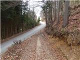 23
23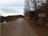 24
24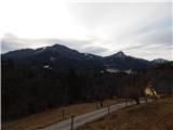 25
25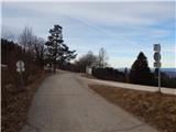 26
26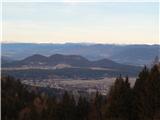 27
27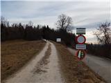 28
28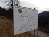 29
29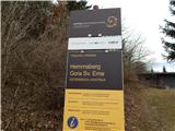 30
30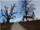 31
31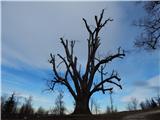 32
32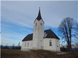 33
33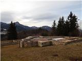 34
34 35
35
Discussion about the trail Globasnica / Globasnitz - Gora sv. Eme (Junska gora) / Hemmaberg