end of road on Pokljuka - Kredarica
Starting point: end of road on Pokljuka (1312 m)
| Lat/Lon: | 46,3386°N 13,9045°E |
| |
Time of walking: 5 h 5 min
Difficulty: difficult marked way
Altitude difference: 1229 m
Altitude difference po putu: 1400 m
Map: Triglav 1:25.000
Recommended equipment (summer): helmet
Recommended equipment (winter): helmet, ice axe, crampons
Views: 32
 | 1 person likes this post |
Access to the starting point:
Path description:
On the way: Planina Konjščica (1427m),
Klanci (1678m),
Jezerce (1719m),
Izvir pod Studorskim prevalom (1746m),
Studorski preval (1892m),
Planina Zgornji Tosc (1849m),
Na Zagonu (1819m),
Vodnikov dom (1817m),
Konjsko sedlo (2020m),
Kalvarija (2288m),
Triglavski dom na Kredarici (2515m)
Pictures:
 1
1 2
2 3
3 4
4 5
5 6
6 7
7 8
8 9
9 10
10 11
11 12
12 13
13 14
14 15
15 16
16 17
17 18
18 19
19 20
20 21
21 22
22 23
23 24
24 25
25 26
26 27
27 28
28 29
29 30
30 31
31 32
32 33
33 34
34 35
35 36
36 37
37 38
38 39
39 40
40 41
41 42
42 43
43 44
44 45
45 46
46 47
47 48
48 49
49 50
50 51
51 52
52 53
53 54
54 55
55 56
56 57
57 58
58 59
59 60
60 61
61 62
62 63
63 64
64 65
65 66
66 67
67 68
68 69
69 70
70 71
71 72
72 73
73 74
74 75
75 76
76 77
77 78
78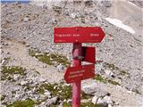 79
79 80
80 81
81 82
82 83
83 84
84 85
85 86
86 87
87 88
88 89
89 90
90 91
91 92
92 93
93 94
94 95
95 96
96 97
97 98
98 99
99
Discussion about the trail end of road on Pokljuka - Kredarica