end of road on Pokljuka - Ablanca
Starting point: end of road on Pokljuka (1312 m)
| Lat/Lon: | 46,3386°N 13,9045°E |
| |
Time of walking: 2 h 20 min
Difficulty: difficult unmarked way
Altitude difference: 692 m
Altitude difference po putu: 695 m
Map: Triglav 1:25.000
Recommended equipment (summer): helmet
Recommended equipment (winter): helmet, ice axe, crampons
Views: 39.071
 | 5 people like this post |
Access to the starting point:
a) Leave the Gorenjska motorway at the exit for Lesce, then follow the signs for Bled and Pokljuka. Continue through Gorje and past the ski resort Zatrnik to Rudni Polje on Pokljuka, where there is a large pay parking lot and a military barracks and shooting range nearby. From here, continue straight along the macadam road, which leads us a little further to a crossroads, where we continue to the right (Uskovnica on the left). Follow this road to the former parking lot Za Ribnico, which is at the end of the road (there are mountain signs for mountain pasture Konjščico).
After the new parking at the end of the road is forbidden, so we park already at Rudne polje, which lengthens the route by about 40 minutes, but it is more convenient to choose the marked trail, which starts already at Rudne polje.
b) From Železniki or Podbrdo, take the road to Bohinjska Bistrica and then continue in the direction of Bled. Shortly after the Petrol station, which is located just after Bohinjska Bistrica, turn left in the direction of Pokljuka and Jereka. The road climbs steeply at first, then gradually flattens out behind Koriti, leading to a junction by the bus station, where you continue right in the direction of Pokljuka, Koprivnik and Jereka (straight ahead Srednja vas). Just after the crossroads we arrive at Jereka, and from the crossroads in front of the church we continue straight on towards Pokljuka (left Podjelje). After Jereka the road starts to climb steeply again, and higher up it levels off and continues along the Mrzle potok. When you join the road from Bled, go left and drive to Rudno Polje, where there is a large pay parking lot, and also a military barracks and a shooting range nearby. From here, continue straight along the macadam road, which leads us a little further to a crossroads, where we continue to the right (Uskovnica on the left). Follow this road to the former parking lot Za Ribnico, which is at the end of the road (there are mountain signs for mountain pasture Konjščico).
After the new parking at the end of the road is forbidden, so we park already at Rudne polje, which lengthens the route by about 40 minutes, but it is more convenient to choose the marked trail, which starts already at Rudne polje.
Path description:
From the former parking lot, continue right up cart track towards mountain pasture Konjščica. Cart track, which climbs steeply at first, soon becomes steep and turns into a footpath a little higher up. A moderate ascent follows, climbing along the Ribnica stream, which has a waterfall in its upper part that can be seen from the path. Further on, the path crosses a small spring and enters the pasture area mountain pasture Konjščica. After a few dozen steps, the path crosses another small spring and ascends gently to the cheese-maker's hut at mountain pasture.
From mountain pasture, continue up the gently sloping meadow slightly to the other side of mountain pasture. There the path becomes dwarf pines and starts to climb, first gently and then steeply. In the last part of the ascent, the path from Rudno Polje joins from the right. There is only a short climb along the torrent to the grassy plain of Jezerce. Here the path turns left and after a few steps leads us into the narrower area of the TNP. Next, we climb along a small spring towards Studorski Preval. A little higher, cross the torrent and the path turns slightly right into the grassy slopes surrounded by dwarf pines. The path then ascends crosswise to Studorski preval, from which a fine view of the Bohinj side opens up.
At the pass where you leave the markings, go left up the path. The path quickly leads us to a crumbly terrain, where we can break rocks (with caution). Then there is a steeper path which leads to a ridge. Follow this path, which is quite dangerous to slip on (due to the quicksand on the path), to the top of Ablanca.

Pictures:
 1
1 2
2 3
3 4
4 5
5 6
6 7
7 8
8 9
9 10
10 11
11 12
12 13
13 14
14 15
15 16
16 17
17 18
18 19
19 20
20 21
21 22
22 23
23 24
24 25
25 26
26 27
27 28
28 29
29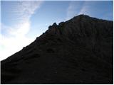 30
30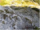 31
31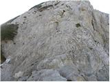 32
32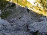 33
33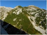 34
34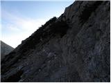 35
35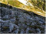 36
36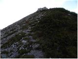 37
37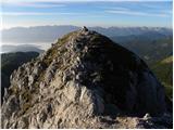 38
38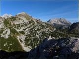 39
39
Discussion about the trail end of road on Pokljuka - Ablanca
|
| gorskarozica22. 09. 2012 |
Ob sestopu s Tosca, še kratek vzpon ob poti na Ablanco, lepo. Priporočljiv vrh, malo pazljivosti pa ne bo odveč! Pot pod noge, ne bo vam žal! 
|
|
|
|
| VesnaM22. 06. 2014 |
mogoče kdo ve koliko je še snega na poti ?
|
|
|
|
| nadap22. 06. 2014 |
Od ravnice Jezerce do Studorskega prevala je še kar zalito, vendar gre z malo več previdnosti. Ablanca brez snega prav tako Veliki Draški vrh. Bila na obeh v četrtek 19.06.2014 v lepem vremenu in s prekrasnimi razgledi.
|
|
|